- Kimba (South Australia)
-
Kimba 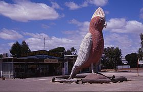
Der Big Galah in KimbaStaat:  Australien
Bundesstaat:  South Australia
Gegründet: 1915 Koordinaten: 33° 8′ S, 136° 25′ O-33.139824136.421135Koordinaten: 33° 8′ S, 136° 25′ O Einwohner: 636 (2006) [1] Zeitzone: ACST (UTC+9:30) Postleitzahl: 5641 LGA: District Council of Kimba 

Kimba Kimba ist ein kleiner Ort, der im Norden der Eyre-Halbinsel in South Australia am Eyre Highway liegt. Die Stadt befindet sich 350 Kilometer östlich von Ceduna und 150 Kilometer westlich von Port Augusta entfernt. Kimba ist ein Wort der Aborigine für Buschfeuer.
Der erste Europäer, der diese Gegend bereiste, war Edward John Eyre im Jahre 1839 auf dem Weg von Streaky Bay zum Spencer Gulf. Allmählich besiedelt wurde der Ort und die Gegend ab 1908. 1913 wurde Kimba mit der Eisenbahn von Port Lincoln erschlossen. Dies führte zu einer weiteren Bevölkerungszunahme, und zwei Jahre später wurde Kimba zur Stadt erklärt. 2006 hatte der Ort 686 Einwohner.[1]
In der Umgebung des Orts wachsen große Eukalyptusbäume. Die Gawler Ranges liegen im Norden des Eyre Highways und der Stadt.
Am Highway wird die halbe Strecke zwischen Ost- zur Westküste durch den Big Galah, einer sieben Meter hohen Statue eines Rosakakadus, markiert. Im Ort gibt es Hotels, Motel und einen Caravanpark.
Weblinks
Einzelnachweise
- ↑ a b Australian Bureau of Statistics (25. Oktober 2007): Kimba (L) (Urban Centre/Locality) (Englisch). 2006 Census QuickStats. Abgerufen am 13. Februar 2011.
Kategorie:- Ort in South Australia


Wikimedia Foundation.