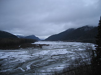
Klehini River

Klehini River
Klehini River
Der Klehini River in der Nähe des Haines Highways

Der Klehini River in der Nähe des Haines HighwaysVorlage:Infobox Fluss/KARTE_fehlt

Daten
Gewässerkennzahl US1423105
Lage British Columbia (Kanada), Alaska (USA)
Flusssystem Chilkat River
Abfluss über Chilkat River → Pazifischer OzeanVorlage:Infobox Fluss/QUELLE_fehltVorlage:Infobox Fluss/QUELLHÖHE_fehlt
Mündung in den Chilkat River
59.41105-135.930948

59° 24′ 40″ N, 135° 55′ 51″ W59.41105-135.930948
Vorlage:Infobox Fluss/MÜNDUNGSHÖHE_fehltVorlage:Infobox Fluss/HÖHENUNTERSCHIED_fehlt
Länge 58 kmVorlage:Infobox Fluss/NACHWEISE_fehlenVorlage:Infobox Fluss/EINZUGSGEBIET_fehlt

Vorlage:Infobox Fluss/ABFLUSS_fehlt

Der Klehini River ist ein gletschergespeister Fluss in der Panhandle des US-Bundesstaats Alaska, nordwestlich von Haines.

Der Klehini ist 58 lang und entspringt in British Columbia nahe der Grenze zu Alaska. Er mündet bei Wells im Alaska Chilkat Bald Eagle Preserve in den Unterlauf des Chilkat Rivers, dessen größter Zufluss er ist. Die Mündung des Tsirku Rivers liegt 2 km weiter südlich. Der Haines Highway verläuft von der Staatsgrenze bis zur Mündung des Klehini in den Chilkat parallel zum Fluss. Der Klehini River bildet die nördliche Grenze der Chilkat Range, einem Gebirgszug der Alsek Ranges in der Eliaskette.

Weblinks


Wikimedia Foundation.

Игры ⚽ Нужно решить контрольную?

Schlagen Sie auch in anderen Wörterbüchern nach:

  • Klehini River — The Klehini River is approximately 36 miles long (58 km) from its source in British Columbia to its mouth at the Chilkat River, of which it is the largest tributary. The Klehini River is renowned for its salmon runs, its biannual congregation of… …   Wikipedia

  • Klehini (rivière) — 59° 25′ 34″ N 136° 10′ 12″ W / 59.426, 136.17 …   Wikipédia en Français

  • Klehini Falls — The Klehini Falls are a series of four cataracts in far northwestern British Columbia occurring in a narrow gorge near the headwaters of the Klehini River. The falls are separated from one another by a distance of approximately 300 feet, with an… …   Wikipedia

  • Chilkat River — Blick von den Takshanuk Mountains auf den Chilkat RiverVorlage:Infobox Fluss/KARTE fehlt …   Deutsch Wikipedia

  • Chilkat River — A view up the Chilkat River valley from the Takshanuk Mountains. The Chilkat River is a river in British Columbia and southeastern Alaska that flows southward from the Coast Range to the Chilkat Inlet and ultimately Lynn Canal. It is about 80… …   Wikipedia

  • Tsirku River — Der Tsirku River westlich des FlussdeltasVorlage:Infobox Fluss/KARTE fehlt Daten …   Deutsch Wikipedia

  • Kelsall River — Gewässerkennzahl US: 1423026 Lage Kanada (British Columbia) und USA (Alaska) …   Deutsch Wikipedia

  • Tsirku River — The Tsirku River is a glacially fed stream located in Southeast Alaska near the town of Haines. The river s source is found at Tsirku Glacier, a large, sprawling ice mass at the border of Alaska and British Columbia, and ends in a massive four… …   Wikipedia

  • List of rivers of Alaska — This is a List of rivers in Alaska, which are at least fifth order according to the Strahler method of stream classification [cite map author = title = Hydrologic Unit Map State of Alaska url = publisher = United States Geological Survey, United… …   Wikipedia

  • Alaska Route 7 — Der Haines Highway am Chilkat River Der Haines Highway bei Meile 46 in British Columbia …   Deutsch Wikipedia

Share the article and excerpts

Direct link
Do a right-click on the link above
and select “Copy Link”