- La Gacilly
-
La Gacilly 
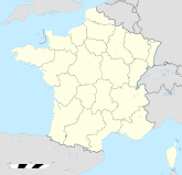
Region Bretagne Département Morbihan Arrondissement Vannes Kanton La Gacilly Koordinaten 47° 46′ N, 2° 8′ W47.765-2.131944444444521Koordinaten: 47° 46′ N, 2° 8′ W Höhe 21 m (4–98 m) Fläche 16,48 km² Einwohner 2.263 (1. Jan. 2008) Bevölkerungsdichte 137 Einw./km² Postleitzahl 56200 INSEE-Code 56061 
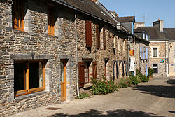
La Gacilly, Rue Saint-VincentLa Gacilly (bretonisch Gazilieg) ist eine französische Gemeinde mit 2263 Einwohnern (Stand 1. Januar 2008) im Département Morbihan in der Region Bretagne.
Inhaltsverzeichnis
Geografie
La Gacilly liegt am Fluss Aff, der etwa zehn Kilometer weiter bei Glénac in den Oust mündet, der hier den Canal de Nantes à Brest bildet. Mit Sport- und Hausbooten ist es möglich, den Aff aufwärts bis nach La Gacilly zu fahren. Die Gemeinde hat hier eine kleine Anlegestelle für Boote eingerichtet.
Geschichte
Die Stadt erlebte den Aufschwung der Kosmetikfirma Yves Rocher von einem kleinen Familienunternehmen zu einer internationalen Firmengruppe.
Sehenswürdigkeiten
- Menhir de la Roche piquée
Megalith-Skulpturen am Ortsausgang Richtung Saint-Martin-sur-Oust - Kirche aus dem 19. Jahrhundert
- Reizendes Stadtviertel mit vielen Kunsthandwerksbetrieben
- Botanischer Garten von Yves Rocher
Städtepartnerschaft
Söhne und Töchter der Gemeinde
Yves Rocher, der Gründer der gleichnamigen Kosmetikfirma, wurde in La Gacilly geboren und war 46 Jahre Bürgermeister des Ortes.[1]
Einzelnachweise
Weblinks
- Tourismusinformationen (französisch)
- Detaillierte Beschreibung der Gemeinde (französisch)
- Besichtigungen und Ausstellungen von Yves Rocher (französisch)
Carentoir | Cournon | Glénac | La Chapelle-Gaceline | La Gacilly | Les Fougerêts | Quelneuc | Saint-Martin-sur-Oust | Tréal
- Menhir de la Roche piquée
Wikimedia Foundation.

