- Lafayette County (Missouri)
-
Verwaltung US-Bundesstaat: Missouri Verwaltungssitz: Lexington Adresse des
Verwaltungssitzes:County Courthouse
1001 Main Street
Lexington, MO 64067-1344Gründung: 1820 Vorwahl: 001 660 Demographie Einwohner: 33.381 (2010) Bevölkerungsdichte: 20,5 Einwohner/km² Geographie Fläche gesamt: 1.655 km² Wasserfläche: 25 km² Karte 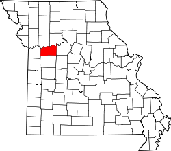
Website: www.lafayettecountymo.com Das Lafayette County[2] ist ein County im US-amerikanischen Bundesstaat Missouri. Bei der Volkszählung im Jahr 2010 hatte das County 33.381 Einwohner und eine Bevölkerungsdichte von 20,5 Einwohnern pro Quadratkilometer. Der Verwaltungssitz (County Seat) ist Lexington.[3]
Das Lafayette County ist Bestandteil der Metropolregion Kansas City.
Inhaltsverzeichnis
Geografie
Das County liegt im mittleren Nordwesten von Missouri und wird im Norden vom Missouri River begrenzt. Es hat eine Fläche von 1.655 Quadratkilometern, wovon 25 Quadratkilometer Wasserfläche sind. An das Lafayette County grenzen folgende Countys:
Ray County Carroll County Jackson County 
Saline County Johnson County Pettis County Geschichte
 La Fayette
Das Lafayette County wurde 1820 gebildet. Benannt wurde es nach dem Marquis de La Fayette (1757-1834), einem französischen General und Politiker, der auf der Seite der Kolonisten am Amerikanischen Unabhängigkeitskrieg teilnahm und eine wichtige Rolle in der Französischen Revolution spielte.
Demografische Daten
Historische Einwohnerzahlen Census Einwohner ± in % 1830 2912 — 1840 6815 100 % 1850 13.690 100 % 1860 20.098 50 % 1870 22.623 10 % 1880 25.710 10 % 1890 30.184 20 % 1900 31.679 5 % 1910 30.154 -5 % 1920 30.006 -0,5 % 1930 29.259 -2 % 1940 27.856 -5 % 1950 25.272 -9 % 1960 25.274 0,008 % 1970 26.626 5 % 1980 29.925 10 % 1990 31.107 4 % 2000 32.960 6 % 2010 33.381 1 % Vor 1900[4] 1900-1990[5] 2000[6] 2010[7] Nach der Volkszählung im Jahr 2010 lebten im Lafayette County 33.381 Menschen in 13.337 Haushalten. Die Bevölkerungsdichte betrug 20,5 Einwohner pro Quadratkilometer.
Ethnisch betrachtet setzte sich die Bevölkerung zusammen aus 94,1 Prozent Weißen, 2,2 Prozent Afroamerikanern, 0,4 Prozent amerikanischen Ureinwohnern, 0,4 Prozent Asiaten sowie aus anderen ethnischen Gruppen; 1,9 Prozent stammten von zwei oder mehr Ethnien ab. Unabhängig von der ethnischen Zugehörigkeit waren 2,2 Prozent der Bevölkerung spanischer oder lateinamerikanischer Abstammung.
In den 13.337 Haushalten lebten statistisch je 2,36 Personen.
24,1 Prozent der Bevölkerung waren unter 18 Jahre alt, 59,2 Prozent waren zwischen 18 und 64 und 16,7 Prozent waren 65 Jahre oder älter. 50,7 Prozent der Bevölkerung war weiblich.
Das jährliche Durchschnittseinkommen eines Haushalts lag bei 45.921 USD. Das Pro - Kopf - Einkommen betrug 22.733 USD. 10,6 Prozent der Einwohner lebten unterhalb der Armutsgrenze.[8]
Städte und Gemeinden
- Alma
- Bates City
- Blackburn1
- Concordia
- Corder
- Emma1
- Higginsville
- Lake Lafayette
- Lexington
- Mayview
- Napoleon
- Oak Grove2
- Odessa
- Waverly
- Wellington
- Aullville
- Dover
1 - teilweise im Saline County
2 - teilweise im Jackson CountyEinzelnachweise
- ↑ Auszug aus dem National Register of Historic Places Abgerufen am 13. März 2011
- ↑ GNIS-ID: 758508. Abgerufen am 22. Februar 2011 (englisch).
- ↑ National Association of Counties Abgerufen am 18. Oktober 2011
- ↑ U.S. Census Bureau - Census of Population and Housing Abgerufen am 15. März 2011
- ↑ Auszug aus Census.gov Abgerufen am 18. Februar 2011
- ↑ Auszug aus factfinder.census.gov Abgerufen am 18. Februar 2011
- ↑ United States Census 2010 Abgerufen am 18. Oktober 2011
- ↑ U.S. Census Buero, State & County QuickFacts - Lafayette County Abgerufen am 18. Oktober 2011
Weblinks
-
 Commons: Lafayette County, Missouri – Sammlung von Bildern, Videos und Audiodateien
 - Offizielle Webseite
- U.S. Census Buero, State & County QuickFacts - Lafayette County
- Yahoo Bildersuche - Lafayette County
- www.city-data.com - Lafayette County

Liste der Countys in Missouri
Adair | Andrew | Atchison | Audrain | Barry | Barton | Bates | Benton | Bollinger | Boone | Buchanan | Butler | Caldwell | Callaway | Camden | Cape Girardeau | Carroll | Carter | Cass | Cedar | Chariton | Christian | Clark | Clay | Clinton | Cole | Cooper | Crawford | Dade | Dallas | Daviess | DeKalb | Dent | Douglas | Dunklin | Franklin | Gasconade | Gentry | Greene | Grundy | Harrison | Henry | Hickory | Holt | Howard | Howell | Iron | Jackson | Jasper | Jefferson | Johnson | Knox | Laclede | Lafayette | Lawrence | Lewis | Lincoln | Linn | Livingston | Macon | Madison | Maries | Marion | McDonald | Mercer | Miller | Mississippi | Moniteau | Monroe | Montgomery | Morgan | New Madrid | Newton | Nodaway | Oregon | Osage | Ozark | Pemiscot | Perry | Pettis | Phelps | Pike | Platte | Polk | Pulaski | Putnam | Ralls | Randolph | Ray | Reynolds | Ripley | Saline | Schuyler | Scotland | Scott | Shannon | Shelby | St. Charles | St. Clair | St. Francois | St. Louis County | St. Louis City | Ste. Genevieve | Stoddard | Stone | Sullivan | Taney | Texas | Vernon | Warren | Washington | Wayne | Webster | Worth | Wright
Wikimedia Foundation.
Schlagen Sie auch in anderen Wörterbüchern nach:
Lafayette County, Missouri — Infobox U.S. County county = Lafayette County state = Missouri founded year = 1820 founded date = November 16 seat wl = Lexington largest city wl = Odessa area total sq mi = 639 area total km2 = 1655 area land sq mi = 629 area land km2 = 1630… … Wikipedia
National Register of Historic Places listings in Lafayette County, Missouri — Map of all coordinates from Google Map of all coordinates from Bing … Wikipedia
Lafayette County — may refer to several locations in the United States: Lafayette County, Arkansas Lafayette County, Florida Lafayette County, Mississippi Lafayette County, Missouri Lafayette County, Wisconsin Lafayette Parish, Louisiana See also Fayette County… … Wikipedia
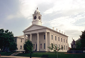
Lafayette County Courthouse (Missouri) — Das Lafayette County Courthouse in Lexington Das Lafayette County Courthouse in Lexington ist das Gerichts und Verwaltungsgebäude des Lafayette County im mittleren Nordwesten des US amerikanischen Bundesstaates Missouri … Deutsch Wikipedia
Lafayette County Courthouse ( Missouri) — The Lafayette County Courthouse is a courthouse in Lexington, Missouri.It was built in 1847 and is the oldest courthouse in continuous use west of the Mississippi River. It is known far and wide for the cannonball embedded in the upper left… … Wikipedia
Lafayette County — Es gibt in den Vereinigten Staaten sechs Countys oder Parishes mit dem Namen Lafayette: Lafayette County (Arkansas) Lafayette County (Florida) Lafayette Parish (Louisiana) Lafayette County (Mississippi) Lafayette County (Missouri) Lafayette… … Deutsch Wikipedia
Lafayette County Courthouse — may refer to:* Lafayette County Courthouse (Arkansas), a property listed on the National Register of Historic Places (NRHP) in Arkansas * Lafayette County Courthouse (Florida), a property listed on the NRHP in Florida * Old Lafayette County… … Wikipedia
Lafayette County High School — Lafayette County C 1 High School is located in Higginsville, Missouri, and serves the Higginsville, Corder, Aullville, and surrounding areas. As of 2005, Lafayette County C 1 High School had over 400 students, and 33 instructors. Lafayette County … Wikipedia
Lafayette County Courthouse — bezeichnet mehrere gleichnamige, im NRHP gelistete, Objekte: Lafayette County Courthouse (Arkansas), ID Nr. 93000085 Lafayette County Courthouse (Mississippi), ID Nr. 77000791 Lafayette County Courthouse (Missouri), ID Nr. 70000339 Lafayette… … Deutsch Wikipedia
Oak Grove, Jackson County, Missouri — This article is about Oak Grove in Jackson/Lafayette Counties. For others, see Oak Grove, Missouri (disambiguation). Oak Grove City … Wikipedia
Lafayette County (Missouri)


18+
© Academic, 2000-2026
- Kontaktieren Sie uns: Unterstützung, Werbung
Wörterbücher Export, schritte mit PHP, Joomla, Drupal, WordPress, MODx.