Lake Bogoria

Lake Bogoria
Bogoriasee
Geographische Lage: Ostafrika, Kenia
Zuflüsse: vor allem heiße Quellen
Abflüsse: keine
Daten
Koordinaten 0° 14′ 46″ N, 36° 6′ 5″ O0.2461111111111136.1013888888897Koordinaten: 0° 14′ 46″ N, 36° 6′ 5″ O
Bogoriasee (Kenia)
DEC
Bogoriasee
Höhe über Meeresspiegel 970 m
Fläche 34 km²dep1
Maximale Tiefe 10 mdep1
Besonderheiten Sodasee, Flamingos, heiße Quellen

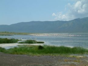
Der Bogoriasee (Lake Bogoria, früher Lake Hannington) ist ein stark alkalischer See im östlichen Arm des Ostafrikanischen Grabens. Der See ist bekannt durch seinen Vogelreichtum, zahlreiche Geysire und heißen Quellen vor allem am Westufer.

Inhaltsverzeichnis

Geographie

Der See liegt im östlichen Teil des Ostafrikanischen Grabenbruchs (Great Rift Valley). Er liegt gemeinsam mit dem nördlich gelegenen Baringosee im Baringo-Bogoria-Becken. Der Bogoriasees liegt in einem Halbgraben, der im Osten von einer Abschiebung und der damit verbundenen morphologischen Bruchstufe (Siracho Escarpment) begrenzt wird. Das Einzugsgebiet des Sees hat eine Größe von 700 km2

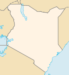
Der See liegt vollständig im Staate Kenia im District Baringo in der Provinz Rift Valley, etwa 285 km nordnordwestlich der Hauptstadt Nairobi.

Flora und Fauna

Der Bogoriasee ist das Ziel zahlreicher Ausflügler, nichtzuletzt wegen der vielfältigen Flora und Fauna. Zur Tierwelt am See gehören Zebras, Gazelle, Impala, Dikdik und Kudu. Der See ist die Heimat zahlreicher Flamingos, Schreiseeadler und Pelikane.

Umwelt

Der Bogoriasee liegt vollständig im Bogoria National Reserve.

Siehe auch

Baringosee

Weblinks


Wikimedia Foundation.

Игры ⚽ Нужно решить контрольную?

Schlagen Sie auch in anderen Wörterbüchern nach:

  • Lake Bogoria — Infobox lake lake name = Lake Bogoria image lake = LakeBogoria.jpg caption lake = Flamingos nesting on the shoreline of the lake image bathymetry = caption bathymetry = location = coords = coord|0|15|N|36|06|E|region:KE… …   Wikipedia

  • Bogoria — may refer to: *Lake Bogoria in Kenya *Gmina Bogoria, a municipality in central Poland *Bogoria, Poland, the chief village in the above municipality *Bogoria, Sandomierz County in Świętokrzyskie Voivodeship (south central Poland) *the Bogoriowie,… …   Wikipedia

  • Bogoria-See — Bogoriasee Geographische Lage: Ostafrika, Kenia Zuflüsse: vor allem heiße Que …   Deutsch Wikipedia

  • Lake Turkana — Infobox lake lake name = Lake Turkana Jade Sea image lake = Lake turkana.jpg caption lake = image bathymetry = caption bathymetry = coords = coord|3|3|N|36|1|E|type:waterbody region:KY/ET|display=inline,title type = Saline, monomictic, alkaline,… …   Wikipedia

  • Lake Naivasha — Infobox lake lake name = Lake Naivasha image lake = Birds at Lake Naivasha (300261994).jpg caption lake = image bathymetry = caption bathymetry = location = coords = coord|0|46|6.70|S|36|21|2.32|E|type:waterbody region:KE|display=inline,title… …   Wikipedia

  • Lake Chew Bahir — The remnants of Lake Chew Bahir as seen from space. Coordinates …   Wikipedia

  • Lake Nakuru — Infobox lake lake name = Lake Nakuru image lake = overview lakenakuru.jpg caption lake = May 2003 image bathymetry = caption bathymetry = location = Central Kenya coords = coord|0|22|S|36|05|E|region:KE type:waterbody|display=inline,title type =… …   Wikipedia

  • Wikiproyecto:Patrimonio de la Humanidad — Patrimonio de la Humanidad …   Wikipedia Español

  • Bogoriasee — Geographische Lage Ostafrika, Kenia Zuflüsse vor allem heiße Quellen Abfluss …   Deutsch Wikipedia

  • Anas capensis — Kapente Kapente (Anas capensis) Systematik Ordnung: Gänsevögel (Anseriformes) F …   Deutsch Wikipedia

Share the article and excerpts

Direct link
Do a right-click on the link above
and select “Copy Link”