- Le Flore County
-
Verwaltung US-Bundesstaat: Oklahoma Verwaltungssitz: Poteau Adresse des
Verwaltungssitzes:County Courthouse
P.O. Box 607
Poteau, OK 74953-0607Gründung: 16. Juli 1907 Gebildet aus: Choctaw-Land Vorwahl: 001 918 Demographie Einwohner: 49.528 (2005) Bevölkerungsdichte: 12,1 Einwohner/km² Geographie Fläche gesamt: 4.165 km² Wasserfläche: 58 km² Karte 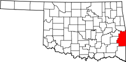
Le Flore County[2] ist ein County im Bundesstaat Oklahoma der Vereinigten Staaten von Amerika. Der Verwaltungssitz (County Seat) ist Poteau.
Inhaltsverzeichnis
Geografie
Das County liegt im Osten von Oklahoma, grenzt an Arkansas und hat eine Fläche von 4165 Quadratkilometern, wovon 58 Quadratkilometer Wasserfläche sind. Es grenzt im Uhrzeigersinn an folgende Countys: Sequoyah County, Sebastian County (Arkansas), Scott County (Arkansas), Polk County (Arkansas), McCurtain County, Pushmataha County, Latimer County und Haskell County.
Geschichte
Le Flore County wurde am 16. Juli 1907 als Original-County aus Choctaw-Land gebildet. Benannt wurde es nach Thomas Le Flore.
Demografische Daten
Historische Einwohnerzahlen Census Einwohner ± in % 1910 29.127 — 1920 42.765 50 % 1930 42.896 0,3 % 1940 45.866 7 % 1950 35.276 -20 % 1960 29.106 -20 % 1970 32.137 10 % 1980 40.698 30 % 1990 43.270 6 % 2000 48.109 10 % 1900–1990[3] 2000[4]
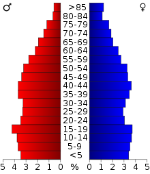 Alterspyramide für das Le Flore County
Nach der Volkszählung im Jahr 2000 lebten im Le Flore County 48.109 Menschen in 17.861 Haushalten und 13.199 Familien. Die Bevölkerungsdichte betrug 12 Einwohner pro Quadratkilometer. Ethnisch betrachtet setzte sich die Bevölkerung zusammen aus 80,35 Prozent Weißen, 2,21 Prozent Afroamerikanern, 10,72 Prozent amerikanischen Ureinwohnern, 0,21 Prozent Asiaten, 0,03 Prozent Bewohnern aus dem pazifischen Inselraum und 1,44 Prozent aus anderen ethnischen Gruppen; 5,03 Prozent stammten von zwei oder mehr Ethnien ab. 3,84 Prozent der Bevölkerung waren spanischer oder lateinamerikanischer Abstammung.
Von den 17.861 Haushalten hatten 33,4 Prozent Kinder unter 18 Jahre, die im Haushalt lebten. 58,5 Prozent waren verheiratete, zusammenlebende Paare, 11,0 Prozent waren allein erziehende Mütter. 26,1 Prozent waren keine Familien, 23,1 Prozent waren Singlehaushalte und in 10,9 Prozent der Haushalte lebten Menschen im Alter von 65 Jahren oder darüber. Die durchschnittliche Haushaltsgröße betrug 2,61 und die durchschnittliche Familiengröße betrug 3,05 Personen.
26,1 Prozent der Bevölkerung waren unter 18 Jahre alt, 9,7 Prozent zwischen 18 und 24, 27,0 Prozent zwischen 25 und 44, 23,3 Prozent zwischen 45 und 64 und 13,8 Prozent waren 65 Jahre oder älter. Das Durchschnittsalter betrug 36 Jahre. Auf 100 weibliche Personen kamen 99,3 männliche Personen. Auf 100 Frauen im Alter von 18 Jahren oder darüber kamen 97,8 Männer.
Das jährliche Durchschnittseinkommen eines Haushalts betrug 27.278 USD und das durchschnittliche Einkommen einer Familie betrug 32.603 USD. Männer hatten ein durchschnittliches Einkommen von 26.214 USD gegenüber den Frauen mit 19.792 USD. Das Prokopfeinkommen betrug 13.737 USD. 15,4 Prozent der Familien und 19,1 Prozent der Bevölkerung lebten unterhalb der Armutsgrenze. [5]
Siehe auch
Einzelnachweise
- ↑ Auszug aus dem National Register of Historic Places. Abgerufen am 13. März 2011
- ↑ Le Flore County im Geographic Names Information System des United States Geological Survey. Abgerufen am 22. Februar 2011
- ↑ Auszug aus Census.gov. Abgerufen am 28. Februar 2011
- ↑ Auszug aus factfinder.census.gov Abgerufen am 28. Februar 2011
- ↑ Le Flore County, Oklahoma, Datenblatt mit den Ergebnissen der Volkszählung im Jahre 2000 bei factfinder.census.gov.

Liste der Countys in Oklahoma
Adair | Alfalfa | Atoka | Beaver | Beckham | Blaine | Bryan | Caddo | Canadian | Carter | Cherokee | Choctaw | Cimarron | Cleveland | Coal | Comanche | Cotton | Craig | Creek | Custer | Delaware | Dewey | Ellis | Garfield | Garvin | Grady | Grant | Greer | Harmon | Harper | Haskell | Hughes | Jackson | Jefferson | Johnston | Kay | Kingfisher | Kiowa | Latimer | Le Flore | Lincoln | Logan | Love | Major | Marshall | Mayes | McClain | McCurtain | McIntosh | Murray | Muskogee | Noble | Nowata | Okfuskee | Oklahoma | Okmulgee | Osage | Ottawa | Pawnee | Payne | Pittsburg | Pontotoc | Pottawatomie | Pushmataha | Roger Mills | Rogers | Seminole | Sequoyah | Stephens | Texas | Tillman | Tulsa | Wagoner | Washington | Washita | Woods | Woodward
Wikimedia Foundation.
Schlagen Sie auch in anderen Wörterbüchern nach:
Le Flore County — Admin ASC 2 Code Orig. name Le Flore County Country and Admin Code US.OK.079 US … World countries Adminstrative division ASC I-II
National Register of Historic Places listings in Le Flore County, Oklahoma — Location of Le Flore County in Oklahoma This is a list of the National Register of Historic Places listings in Le Flore County, Oklahoma. This is intended to be a complete list of the properties and districts on the National Register of Historic… … Wikipedia
Le Flore County, Oklahoma — Infobox U.S. County county = Le Flore County state = Oklahoma founded year = 1907 founded date = seat wl = Poteau largest city wl = area total sq mi = 1608 area total km2 = 4165 area land sq mi = 1586 area land km2 = 4107 area water sq mi = 22… … Wikipedia
Flore, Northamptonshire — Flore is a village in the Daventry district of the county of Northamptonshire in England. The A45 road runs through the centre of the village. External links *oscoor gbx|SP645603 … Wikipedia
Condado de Le Flore — Condado de los Estados Unidos Ubicació … Wikipedia Español
Choctaw County (Oklahoma) — Verwaltung US Bundesstaat: Oklahoma Verwaltungssitz: Hugo Adresse des Verwaltungssitzes: County Courthouse 300 East Duke Street Hugo, OK 74743 4009 Gründung: 16. Juli 1907 … Deutsch Wikipedia
List of Oklahoma county name etymologies — This is a list of Oklahoma county name etymologies. Alphabetical, by first letter A *Adair County, Oklahoma: Adair was named for the Adair family of the Cherokee tribe. *Alfalfa County, Oklahoma: Alfala was named for William Henry David Alfalfa… … Wikipedia
List of Oklahoma school districts by county — This list only includes the public school districts in the state of Oklahoma, of which there are approximately 471 as of Fall 2003. The trend is toward a consolidation every year or two, which is slowly lessening this number.*Adair County,… … Wikipedia
Comté de Le Flore — 34° 54′ N 94° 42′ W / 34.90, 94.70 … Wikipédia en Français
McCurtain County, Oklahoma — Location in the state of Oklahoma … Wikipedia
Le Flore County


18+
© Academic, 2000-2026
- Kontaktieren Sie uns: Unterstützung, Werbung
Wörterbücher Export, schritte mit PHP, Joomla, Drupal, WordPress, MODx.