- Woods County
-
Verwaltung US-Bundesstaat: Oklahoma Verwaltungssitz: Alva Adresse des
Verwaltungssitzes:County Courthouse
P.O. Box 386
Alva, OK 73717-0386Gründung: 1893 Gebildet aus: Cherokee-Land Vorwahl: 001 580 Demographie Einwohner: 8546 (2005) Bevölkerungsdichte: 2,6 Einwohner/km² Geographie Fläche gesamt: 3.341 km² Wasserfläche: 9 km² Karte 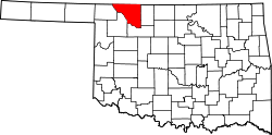
Woods County[1] ist ein County im Bundesstaat Oklahoma der Vereinigten Staaten von Amerika. Der Verwaltungssitz (County Seat) ist Alva.
Inhaltsverzeichnis
Geografie
Das County liegt im Nordwesten von Oklahoma, grenzt im Norden an Kansas und hat eine Fläche von 3341 Quadratkilometern, wovon 9 Quadratkilometer Wasserfläche sind. Es grenzt im Uhrzeigersinn an folgende Countys: Comanche County (Kansas), Barber County (Kansas), Alfalfa County, Major County, Woodward County, und Harper County.
Geschichte
Woods County wurde 1893 als Original-County aus Cherokee-Land gebildet. Benannt wurde s nach Sam Wood, einem kanadischen Geschäftsmann und Politiker. Besiedelt wurde das County durch weiße Siedler während der vierten offiziellen Land-Besitznahme (Oklahoma Land Run) vom 16. September 1893.
Demografische Daten
Historische Einwohnerzahlen Census Einwohner ± in % 1910 18.650 — 1920 22.433 20 % 1930 24.390 9 % 1940 20.754 -10 % 1950 17.598 -20 % 1960 14.654 -20 % 1970 12.901 -10 % 1980 12.398 -4 % 1990 10.384 -20 % 2000 9089 -10 % 1900–1990[2] 2000[3]
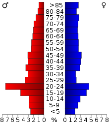 Alterspyramide für das Woods County
Nach der Volkszählung im Jahr 2000 lebten im Woods County 9.089 Menschen in 3.684 Haushalten und 2.243 Familien. Die Bevölkerungsdichte betrug 3 Einwohner pro Quadratkilometer. Ethnisch betrachtet setzte sich die Bevölkerung zusammen aus 93,41 Prozent Weißen, 2,38 Prozent Afroamerikanern, 1,61 Prozent amerikanischen Ureinwohnern, 0,53 Prozent Asiaten, 0,03 Prozent Bewohnern aus dem pazifischen Inselraum und 0,56 Prozent aus anderen ethnischen Gruppen; 1,49 Prozent stammten von zwei oder mehr Ethnien ab. 2,42 Prozent der Bevölkerung waren spanischer oder lateinamerikanischer Abstammung.
Von den 3.684 Haushalten hatten 24,1 Prozent Kinder unter 18 Jahre, die im Haushalt lebten. 50,9 Prozent waren verheiratete, zusammenlebende Paare, 7,3 Prozent waren allein erziehende Mütter. 39,1 Prozent waren keine Familien, 33,4 Prozent waren Singlehaushalte und in 16,4 Prozent der Haushalte lebten Menschen im Alter von 65 Jahren oder darüber. Die durchschnittliche Haushaltsgröße betrug 2,20 und die durchschnittliche Familiengröße betrug 2,81 Personen.
19,2 Prozent der Bevölkerung waren unter 18 Jahre alt, 16,8 Prozent zwischen 18 und 24, 23,2 Prozent zwischen 25 und 44, 20,9 Prozent zwischen 45 und 64 und 19,9 Prozent waren 65 Jahre oder älter. Das Durchschnittsalter betrug 38 Jahre. Auf 100 weibliche Personen kamen 103,9 männliche Personen. Auf 100 Frauen im Alter von 18 Jahren oder darüber kamen 101,7 Männer.
Das jährliche Durchschnittseinkommen eines Haushalts betrug 28.927 USD und das durchschnittliche Einkommen einer Familie betrug 39.143 USD. Männer hatten ein durchschnittliches Einkommen von 26.651 USD gegenüber den Frauen mit 18.968 USD. Das Prokopfeinkommen betrug 17.487 USD. 8,7 Prozent der Familien und 15,0 Prozent der Bevölkerung lebten unterhalb der Armutsgrenze. [4]
Siehe auch
Einzelnachweise
- ↑ Woods County im Geographic Names Information System des United States Geological Survey. Abgerufen am 22. Februar 2011
- ↑ Auszug aus Census.gov. Abgerufen am 28. Februar 2011
- ↑ Auszug aus factfinder.census.gov Abgerufen am 28. Februar 2011
- ↑ Woods County, Oklahoma, Datenblatt mit den Ergebnissen der Volkszählung im Jahre 2000 bei factfinder.census.gov.

Liste der Countys in Oklahoma
Adair | Alfalfa | Atoka | Beaver | Beckham | Blaine | Bryan | Caddo | Canadian | Carter | Cherokee | Choctaw | Cimarron | Cleveland | Coal | Comanche | Cotton | Craig | Creek | Custer | Delaware | Dewey | Ellis | Garfield | Garvin | Grady | Grant | Greer | Harmon | Harper | Haskell | Hughes | Jackson | Jefferson | Johnston | Kay | Kingfisher | Kiowa | Latimer | Le Flore | Lincoln | Logan | Love | Major | Marshall | Mayes | McClain | McCurtain | McIntosh | Murray | Muskogee | Noble | Nowata | Okfuskee | Oklahoma | Okmulgee | Osage | Ottawa | Pawnee | Payne | Pittsburg | Pontotoc | Pottawatomie | Pushmataha | Roger Mills | Rogers | Seminole | Sequoyah | Stephens | Texas | Tillman | Tulsa | Wagoner | Washington | Washita | Woods | Woodward
Wikimedia Foundation.
Schlagen Sie auch in anderen Wörterbüchern nach:
Woods County — Admin ASC 2 Code Orig. name Woods County Country and Admin Code US.OK.151 US … World countries Adminstrative division ASC I-II
Woods County, Oklahoma — Infobox U.S. County county = Woods County state = Oklahoma founded year = founded date = seat wl = Alva largest city wl = city type = area total sq mi = 1290 area total km2 = 3341 area land sq mi = 1287 area land km2 = 3332 area water sq mi = 4… … Wikipedia
Lake of the Woods County — Verwaltung US Bundesstaat: Minnesota Verwaltungssitz: Baudette Adresse des Verwaltungssitzes: County Courthouse 206 SE 8th Avenue Baudette, MN 56623 0000 Gründung: 28. November 1922 … Deutsch Wikipedia
Lake of the Woods County, Minnesota — Infobox U.S. County county = Lake of the Woods County state = Minnesota founded year = 1923 [http://www.house.leg.state.mn.us/hinfo/govseries/No32.htm] founded date = January 1 seat wl = Baudette largest city wl = Baudette area total sq mi = 1775 … Wikipedia
National Register of Historic Places listings in Woods County, Oklahoma — Location of Woods County in Oklahoma This is a list of the National Register of Historic Places listings in Woods County, Oklahoma. This is intended to be a complete list of the properties on the National Register of Historic Places in Woods… … Wikipedia
Chilgren Township, Lake of the Woods County, Minnesota — Chilgren Township is a township in Lake of the Woods County, Minnesota, United States. The population was 179 at the 2000 census. Geography According to the United States Census Bureau, the township has a total area of 36.0 square miles… … Wikipedia
McDougald Township, Lake of the Woods County, Minnesota — McDougald Township is a township in Lake of the Woods County, Minnesota, United States. The population was 236 at the 2000 census. Geography According to the United States Census Bureau, the township has a total area of 35.3 square miles (91 … Wikipedia
Myhre Township, Lake of the Woods County, Minnesota — Myhre Township is a township in Lake of the Woods County, Minnesota, United States. The population was 213 at the 2000 census. Geography According to the United States Census Bureau, the township has a total area of 35.8 square miles… … Wikipedia
Spooner Township, Lake of the Woods County, Minnesota — Spooner Township is a township in Lake of the Woods County, Minnesota, United States. The population was 281 at the 2000 census. Spooner Township adjoined the Village of Spooner, which merged with Baudette in 1954. [ [http://www.co.lake of the… … Wikipedia
Lakewood Township, Lake of the Woods County, Minnesota — Lakewood Township is a township in Lake of the Woods County, Minnesota, United States. The population was 116 at the 2000 census. It borders the Lake of the Woods.GeographyAccording to the United States Census Bureau, the township has a total… … Wikipedia
Woods County


18+
© Academic, 2000-2026
- Kontaktieren Sie uns: Unterstützung, Werbung
Wörterbücher Export, schritte mit PHP, Joomla, Drupal, WordPress, MODx.