- Lee County (South Carolina)
-
Verwaltung US-Bundesstaat: South Carolina Verwaltungssitz: Bishopville Adresse des
Verwaltungssitzes:County Courthouse
P.O. Box 309
Bishopville, SC 29010-0000Gründung: 1902 Vorwahl: 001 803 Demographie Einwohner: 20.638 (2005) Bevölkerungsdichte: 19,4 Einwohner/km² Geographie Fläche gesamt: 1.065 km² Wasserfläche: 3 km² Karte 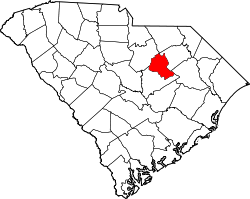
Lee County[1] ist ein County im Bundesstaat South Carolina der Vereinigten Staaten von Amerika. Der Verwaltungssitz (County Seat) ist Bishopville.
Inhaltsverzeichnis
Geografie
Das County liegt nordöstlich des geographischen Zentrums von South Carolina und hat eine Fläche von 1065 Quadratkilometern, wovon 3 Quadratkilometer Wasserfläche sind. Es grenzt im Uhrzeigersinn an folgende Countys: Darlington County, Florence County, Sumter County und Kershaw County.
Geschichte
Lee County wurde 1902 gebildet. Benannt wurde es nach Robert Edward Lee dem kommandierenden General der Konföderierten im Amerikanischen Bürgerkrieg.
Demografische Daten
Historische Einwohnerzahlen Census Einwohner ± in % 1910 25.318 — 1920 26.827 6 % 1930 24.096 -10 % 1940 24.908 3 % 1950 23.173 -7 % 1960 21.832 -6 % 1970 18.323 -20 % 1980 18.929 3 % 1990 18.437 -3 % 2000 20.119 9 % 1900–1990[2] 2000[3]
Nach der Volkszählung im Jahr 2000 lebten im Lee County 20.119 Menschen in 6.886 Haushalten und 4.916 Familien. Die Bevölkerungsdichte betrug 19 Einwohner pro Quadratkilometer. Ethnisch betrachtet setzte sich die Bevölkerung zusammen aus 35,03 Prozent Weißen, 63,56 Prozent Afroamerikanern, 0,13 Prozent amerikanischen Ureinwohnern, 0,19 Prozent Asiaten und 0,59 Prozent aus anderen ethnischen Gruppen; 0,49 Prozent stammten von zwei oder mehr Ethnien ab. 1,31 Prozent der Bevölkerung waren spanischer oder lateinamerikanischer Abstammung.
Von den 6.886 Haushalten hatten 32,7 Prozent Kinder unter 18 Jahre, die bei ihnen lebten. 43,0 Prozent waren verheiratete, zusammenlebende Paare, 23,8 Prozent waren allein erziehende Mütter, 28,6 Prozent waren keine Familien, 25,9 Prozent waren Singlehaushalte und in 10,6 Prozent lebten Menschen mit 65 Jahren oder darüber. Die Durchschnittshaushaltsgröße betrug 2,68 und die durchschnittliche Familiengröße betrug 3,23 Personen.
25,8 Prozent der Bevölkerung war unter 18 Jahre alt. 10,0 Prozent zwischen 18 und 24, 29,2 Prozent zwischen 25 und 44, 22,6 Prozent zwischen 45 und 64 und 12,4 Prozent waren 65 Jahre alt oder älter. Das Durchschnittsalter betrug 36 Jahre. Auf 100 weibliche Personen kamen 101,4 männliche Personen und auf 100 Frauen im Alter von 18 Jahren und darüber kamen 101,1 Männer.
Das jährliche Durchschnittseinkommen eines Haushalts betrug 26.907 USD, das Durchschnittseinkommen einer Familie betrug 34.209 USD. Männer hatten ein Durchschnittseinkommen von 26.512 USD, Frauen 18.993 USD. Das Prokopfeinkommen betrug 13.896 USD. 17,7 Prozent der Familien und 21,8 Prozent der Bevölkerung lebten unterhalb der Armutsgrenze. [4]
Siehe auch
Einzelnachweise
- ↑ Lee County im Geographic Names Information System des United States Geological Survey. Abgerufen am 22. Februar 2011
- ↑ Auszug aus Census.gov. Abgerufen am 28. Februar 2011
- ↑ Auszug aus factfinder.census.gov Abgerufen am 28. Februar 2011
- ↑ Lee County, South Carolina, Datenblatt mit den Ergebnissen der Volkszählung im Jahre 2000 bei factfinder.census.gov.

Liste der Countys in South Carolina
Abbeville | Aiken | Allendale | Anderson | Bamberg | Barnwell | Beaufort | Berkeley | Calhoun | Charleston | Cherokee | Chester | Chesterfield | Clarendon | Colleton | Darlington | Dillon | Dorchester | Edgefield | Fairfield | Florence | Georgetown | Greenville | Greenwood | Hampton | Horry | Jasper | Kershaw | Lancaster | Laurens | Lee | Lexington | Marion | Marlboro | McCormick | Newberry | Oconee | Orangeburg | Pickens | Richland | Saluda | Spartanburg | Sumter | Union | Williamsburg | York
Wikimedia Foundation.
Schlagen Sie auch in anderen Wörterbüchern nach:
Lee County, South Carolina — Infobox U.S. County county = Lee County state = South Carolina map size = 200 founded = 1902 seat = Bishopville | area total sq mi =411 area land sq mi =410 area water sq mi =1 area percentage = 0.24% census yr = 2000 pop = 20119 density km2 =19… … Wikipedia
National Register of Historic Places listings in Lee County, South Carolina — Location of Lee County in South Carolina This is a list of the National Register of Historic Places listings in Lee County, South Carolina. This is intended to be a complete list of the properties and districts on the National Register of… … Wikipedia
Darlington County, South Carolina — For the song of the same name, see Darlington County (song). Darlington County, South Carolina Location in the state of South Carolina … Wikipedia
Kershaw County, South Carolina — Infobox U.S. County county = Kershaw County state = South Carolina map size = 200 founded = 1801 seat = Camden | area total sq mi =740 area land sq mi =726 area water sq mi =14 area percentage = 1.89% census yr = 2000 pop = 52647 density km2 =28… … Wikipedia
Sumter County, South Carolina — Infobox U.S. County county = Sumter County state = South Carolina map size = 200 founded = 1798 seat = Sumter | area total sq mi =682 area land sq mi =665 area water sq mi =17 area percentage = 2.44% census yr = 2000 pop = 104646 density km2 =61… … Wikipedia
Florence County, South Carolina — Infobox U.S. County county = Florence County state = South Carolina map size = 200 founded = 1888 seat = Florence | area total sq mi =804 area land sq mi =800 area water sq mi =4 area percentage = 0.49% census est = 2005 pop = 131097 density km2 … Wikipedia
Lee County, North Carolina — Infobox U.S. County county = Lee County state = North Carolina map size = 250 founded = 1907 seat = Sanford | area total sq mi =259 area water sq mi =2 area percentage = 0.80% census yr = 2000 pop = 49040 density km2 =74 web = www.leecountync.com … Wikipedia
Clarendon County, South Carolina — Location in the state of South Carolina … Wikipedia
Cherokee County, South Carolina — Location in the state of South Carolina … Wikipedia
Charleston County, South Carolina — Seal … Wikipedia
Lee County (South Carolina)

18+
© Academic, 2000-2026
- Kontaktieren Sie uns: Unterstützung, Werbung
Wörterbücher Export, schritte mit PHP, Joomla, Drupal, WordPress, MODx.