- Lancaster County (South Carolina)
-
Verwaltung US-Bundesstaat: South Carolina Verwaltungssitz: Lancaster Adresse des
Verwaltungssitzes:County Courthouse
P.O. Box 1809
Lancaster, SC 29721-1809Gründung: 1798 Vorwahl: 001 803 Demographie Einwohner: 63.113 (2005) Bevölkerungsdichte: 44,4 Einwohner/km² Geographie Fläche gesamt: 1.438 km² Wasserfläche: 16 km² Karte 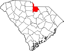
Website: lancastercountysc.net Lancaster County[1] ist ein County im Bundesstaat South Carolina der Vereinigten Staaten von Amerika. Der Verwaltungssitz (County Seat) ist Lancaster.
Inhaltsverzeichnis
Geografie
Das County liegt im Norden von South Carolina, grenzt an North Carolina und hat eine Fläche von 1438 Quadratkilometern, wovon 16 Quadratkilometer Wasserfläche sind. Es grenzt im Uhrzeigersinn an folgende Countys: Mecklenburg County (North Carolina), Union County (North Carolina), Chesterfield County, Kershaw County, Fairfield County, York County und Chester County.
Geschichte
Lancaster County wurde 1798 gebildet. Benannt wurde es nach dem Lancaster County in Pennsylvania.
Demografische Daten
Historische Einwohnerzahlen Census Einwohner ± in % 1790 6302 — 1800 6012 -5 % 1810 6318 5 % 1820 8716 40 % 1830 10.361 20 % 1840 9907 -4 % 1850 10.988 10 % 1860 11.797 7 % 1870 12.087 2 % 1880 16.903 40 % 1890 20.761 20 % 1900 24.311 20 % 1910 26.650 10 % 1920 28.628 7 % 1930 27.980 -2 % 1940 33.542 20 % 1950 37.071 10 % 1960 39.352 6 % 1970 43.328 10 % 1980 53.361 20 % 1990 54.516 2 % 2000 61.351 10 % Vor 1900[2] Nach der Volkszählung im Jahr 2000 lebten im Lancaster County 61.351 Menschen in 23.178 Haushalten und 16.850 Familien. Die Bevölkerungsdichte betrug 43 Einwohner pro Quadratkilometer. Ethnisch betrachtet setzte sich die Bevölkerung zusammen aus 71,03 Prozent Weißen, 26,86 Prozent Afroamerikanern, 0,22 Prozent amerikanischen Ureinwohnern, 0,27 Prozent Asiaten, 0,02 Prozent Bewohnern aus dem pazifischen Inselraum und 0,89 Prozent aus anderen ethnischen Gruppen; 0,71 Prozent stammten von zwei oder mehr Ethnien ab. 1,59 Prozent der Bevölkerung waren spanischer oder lateinamerikanischer Abstammung.
Von den 23.178 Haushalten hatten 33,4 Prozent Kinder unter 18 Jahre, die bei ihnen lebten. 52,6 Prozent waren verheiratete, zusammenlebende Paare, 15,5 Prozent waren allein erziehende Mütter, 27,3 Prozent waren keine Familien, 23,7 Prozent waren Singlehaushalte und in 9,4 Prozent lebten Menschen mit 65 Jahren oder darüber. Die Durchschnittshaushaltsgröße betrug 2,56 und die durchschnittliche Familiengröße betrug 3,01 Personen.
25,4 Prozent der Bevölkerung war unter 18 Jahre alt. 8,6 Prozent zwischen 18 und 24, 30,3 Prozent zwischen 25 und 44, 23,6 Prozent zwischen 45 und 64 und 12,1 Prozent waren 65 Jahre alt oder älter. Das Durchschnittsalter betrug 36 Jahre. Auf 100 weibliche Personen kamen 98,2 männliche Personen und auf 100 Frauen im Alter von 18 Jahren und darüber kamen 95,4 Männer.
Das jährliche Durchschnittseinkommen eines Haushalts betrug 34.688 USD, das Durchschnittseinkommen einer Familie betrug 40.955 USD. Männer hatten ein Durchschnittseinkommen von 30.176 USD, Frauen 22.238 USD. Das Prokopfeinkommen betrug 16.276 USD. 9,7 Prozent der Familien und 12,8 Prozent der Bevölkerung lebten unterhalb der Armutsgrenze. [5]
Siehe auch
Einzelnachweise
- ↑ Lancaster County im Geographic Names Information System des United States Geological Survey. Abgerufen am 22. Februar 2011
- ↑ U.S. Census Bureau - Census of Population and Housing. Abgerufen am 15. März 2011
- ↑ Auszug aus Census.gov. Abgerufen am 28. Februar 2011
- ↑ Auszug aus factfinder.census.gov Abgerufen am 28. Februar 2011
- ↑ Lancaster County, South Carolina, Datenblatt mit den Ergebnissen der Volkszählung im Jahre 2000 bei factfinder.census.gov.

Liste der Countys in South Carolina
Abbeville | Aiken | Allendale | Anderson | Bamberg | Barnwell | Beaufort | Berkeley | Calhoun | Charleston | Cherokee | Chester | Chesterfield | Clarendon | Colleton | Darlington | Dillon | Dorchester | Edgefield | Fairfield | Florence | Georgetown | Greenville | Greenwood | Hampton | Horry | Jasper | Kershaw | Lancaster | Laurens | Lee | Lexington | Marion | Marlboro | McCormick | Newberry | Oconee | Orangeburg | Pickens | Richland | Saluda | Spartanburg | Sumter | Union | Williamsburg | York
Wikimedia Foundation.
Schlagen Sie auch in anderen Wörterbüchern nach:
Lancaster County, South Carolina — Infobox U.S. County county = Lancaster County state = South Carolina map size = 200 founded = 1798 seat = Lancaster | area total sq mi = 555 area land sq mi =549 area water sq mi =6 area percentage = 1.13% census yr = 2008 pop = 75,000 density… … Wikipedia
National Register of Historic Places listings in Lancaster County, South Carolina — Location of Lancaster County in South Carolina This is a list of the National Register of Historic Places listings in Lancaster County, South Carolina. This is intended to be a complete list of the properties and districts on the National… … Wikipedia
Elgin, Lancaster County, South Carolina — Elgin is a census designated place (CDP) in Lancaster County, South Carolina, United States. The population was 2,426 at the 2000 census.GeographyElgin is located at coor dms|34|40|33|N|80|43|45|W|city (34.675799, 80.729080)GR|1.According to the… … Wikipedia
Springdale, Lancaster County, South Carolina — Springdale is a census designated place (CDP) in Lancaster County, South Carolina, United States. The population was 2,864 at the 2000 census.GeographySpringdale is located at coor dms|34|41|46|N|80|47|3|W|city (34.696147,… … Wikipedia
Lancaster Mill, South Carolina — Infobox Settlement official name = Lancaster, South Carolina settlement type = CDP nickname = The Red Rose City motto = imagesize = image caption = image |pushpin pushpin label position =left pushpin map caption =Location within the state of… … Wikipedia
Chesterfield County, South Carolina — Seal … Wikipedia
Chester County, South Carolina — Location in the state of South Carolina … Wikipedia
York County, South Carolina — Infobox U.S. County county = York County state = South Carolina map size = 200 founded = 1785 seat = York largest city = Rock Hill area total sq mi =696 area land sq mi =682 area water sq mi =13 area percentage = 1.91% census yr = 2000 pop =… … Wikipedia
Kershaw County, South Carolina — Infobox U.S. County county = Kershaw County state = South Carolina map size = 200 founded = 1801 seat = Camden | area total sq mi =740 area land sq mi =726 area water sq mi =14 area percentage = 1.89% census yr = 2000 pop = 52647 density km2 =28… … Wikipedia
Fairfield County, South Carolina — Infobox U.S. County county = Fairfield County state = South Carolina map size = 200 founded = 1785 seat = Winnsboro | area total sq mi =710 area land sq mi =687 area water sq mi =23 area percentage = 3.29% census yr = 2000 pop = 23454 density km2 … Wikipedia
Lancaster County (South Carolina)

18+
© Academic, 2000-2026
- Kontaktieren Sie uns: Unterstützung, Werbung
Wörterbücher Export, schritte mit PHP, Joomla, Drupal, WordPress, MODx.