- Richland County (South Carolina)
-
Verwaltung US-Bundesstaat: South Carolina Verwaltungssitz: Columbia Adresse des
Verwaltungssitzes:County Courthouse
P.O. Box 192
Columbia, SC 29202-0192Gründung: 1799 Vorwahl: 001 803 Demographie Einwohner: 340.078 (2005) Bevölkerungsdichte: 173,6 Einwohner/km² Geographie Fläche gesamt: 1.999 km² Wasserfläche: 40 km² Karte 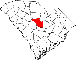
Website: www.richlandonline.com Richland County[1] ist ein County im Bundesstaat South Carolina der Vereinigten Staaten von Amerika. Der Verwaltungssitz (County Seat) ist Columbia.
Inhaltsverzeichnis
Geografie
Das County liegt auf dem geographischen Zentrum von South Carolina und hat eine Fläche von 1999 Quadratkilometern, wovon 40 Quadratkilometer Wasserfläche sind. Es grenzt im Uhrzeigersinn an folgende Countys: Fairfield County, Kershaw County, Sumter County, Calhoun County, Lexington County und Newberry County.
Geschichte
Richland County wurde 1799 gebildet. Benannt wurde es nach der reichlich vorhandenen guten Erde.
Demografische Daten
Historische Einwohnerzahlen Census Einwohner ± in % 1790 3930 — 1800 6097 60 % 1810 9027 50 % 1820 12.321 40 % 1830 14.772 20 % 1840 16.397 10 % 1850 20.243 20 % 1860 18.307 -10 % 1870 23.025 30 % 1880 28.573 20 % 1890 36.821 30 % 1900 45.589 20 % 1910 55.143 20 % 1920 78.122 40 % 1930 87.667 10 % 1940 104.843 20 % 1950 142.565 40 % 1960 200.102 40 % 1970 233.868 20 % 1980 269.735 20 % 1990 285.720 6 % 2000 320.677 10 % Vor 1900[2] Nach der Volkszählung im Jahr 2000 lebten im Richland County 320.677 Menschen in 120.101 Haushalten und 76.384 Familien. Die Bevölkerungsdichte betrug 164 Einwohner pro Quadratkilometer. Ethnisch betrachtet setzte sich die Bevölkerung zusammen aus 50,29 Prozent Weißen, 45,16 Prozent Afroamerikanern, 0,24 Prozent amerikanischen Ureinwohnern, 1,72 Prozent Asiaten, 0,08 Prozent Bewohnern aus dem pazifischen Inselraum und 1,16 Prozent aus anderen ethnischen Gruppen; 1,35 Prozent stammten von zwei oder mehr Ethnien ab. 2,72 Prozent der Bevölkerung waren spanischer oder lateinamerikanischer Abstammung.
Von den 120.101 Haushalten hatten 31,5 Prozent Kinder unter 18 Jahre, die bei ihnen lebten. 43,7 Prozent waren verheiratete, zusammenlebende Paare, 16,3 Prozent waren allein erziehende Mütter, 36,4 Prozent waren keine Familien, 29,1 Prozent waren Singlehaushalte und in 7,3 Prozent lebten Menschen mit 65 Jahren oder darüber. Die Durchschnittshaushaltsgröße betrug 2,44 und die durchschnittliche Familiengröße betrug 3,05 Personen.
24,2 Prozent der Bevölkerung war unter 18 Jahre alt. 13,8 Prozent zwischen 18 und 24, 31,6 Prozent zwischen 25 und 44, 20,6 Prozent zwischen 45 und 64 und 9,8 Prozent waren 65 Jahre alt oder älter. Das Durchschnittsalter betrug 33 Jahre. Auf 100 weibliche Personen kamen 93,2 männliche Personen und auf 100 Frauen im Alter von 18 Jahren und darüber kamen 89,8 Männer.
Das jährliche Durchschnittseinkommen eines Haushalts betrug 39.961 USD, das Durchschnittseinkommen einer Familie betrug 49.466 USD. Männer hatten ein Durchschnittseinkommen von 34.346 USD, Frauen 25.909 USD. Das Prokopfeinkommen betrug 20.794 USD. 10,1 Prozent der Familien und 13,7 Prozent der Bevölkerung lebten unterhalb der Armutsgrenze. [5]
Siehe auch
Einzelnachweise
- ↑ Richland County im Geographic Names Information System des United States Geological Survey. Abgerufen am 22. Februar 2011
- ↑ U.S. Census Bureau - Census of Population and Housing. Abgerufen am 15. März 2011
- ↑ Auszug aus Census.gov. Abgerufen am 28. Februar 2011
- ↑ Auszug aus factfinder.census.gov Abgerufen am 28. Februar 2011
- ↑ Richland County, South Carolina, Datenblatt mit den Ergebnissen der Volkszählung im Jahre 2000 bei factfinder.census.gov.

Liste der Countys in South Carolina
Abbeville | Aiken | Allendale | Anderson | Bamberg | Barnwell | Beaufort | Berkeley | Calhoun | Charleston | Cherokee | Chester | Chesterfield | Clarendon | Colleton | Darlington | Dillon | Dorchester | Edgefield | Fairfield | Florence | Georgetown | Greenville | Greenwood | Hampton | Horry | Jasper | Kershaw | Lancaster | Laurens | Lee | Lexington | Marion | Marlboro | McCormick | Newberry | Oconee | Orangeburg | Pickens | Richland | Saluda | Spartanburg | Sumter | Union | Williamsburg | York
Wikimedia Foundation.
Schlagen Sie auch in anderen Wörterbüchern nach:
Richland County, South Carolina — Infobox U.S. County county = Richland County state = South Carolina map size = 225 founded = 1785 seat = Columbia | largest city = Columbia area total sq mi =772 area land sq mi =756 area water sq mi =15 area percentage = 1.98% census yr = 2000… … Wikipedia
National Register of Historic Places listings in Richland County, South Carolina — Location of Richland County in South Carolina This is a list of the National Register of Historic Places listings in Richland County, South Carolina. This is intended to be a complete list of the properties and districts on the National Register… … Wikipedia
Millwood (Richland County, South Carolina) — Millwood U.S. National Register of Historic Places … Wikipedia
List of Registered Historic Places in Richland County, South Carolina — List of Registered Historic Places in Richland County, South Carolina:This list has been transferred from List of Registered Historic Places in South Carolina =Richland County= * Ballentine ** John Jacob Calhoun Koon Farmstead * Blythewood **… … Wikipedia
Newberry County, South Carolina — Location in the state of South Carolina … Wikipedia
Kershaw County, South Carolina — Infobox U.S. County county = Kershaw County state = South Carolina map size = 200 founded = 1801 seat = Camden | area total sq mi =740 area land sq mi =726 area water sq mi =14 area percentage = 1.89% census yr = 2000 pop = 52647 density km2 =28… … Wikipedia
Fairfield County, South Carolina — Infobox U.S. County county = Fairfield County state = South Carolina map size = 200 founded = 1785 seat = Winnsboro | area total sq mi =710 area land sq mi =687 area water sq mi =23 area percentage = 3.29% census yr = 2000 pop = 23454 density km2 … Wikipedia
Sumter County, South Carolina — Infobox U.S. County county = Sumter County state = South Carolina map size = 200 founded = 1798 seat = Sumter | area total sq mi =682 area land sq mi =665 area water sq mi =17 area percentage = 2.44% census yr = 2000 pop = 104646 density km2 =61… … Wikipedia
Lexington County, South Carolina — Infobox U.S. County county = Lexington County state = South Carolina map size = 200 founded = 1804 seat = Lexington | area total sq mi =758 area land sq mi =699 area water sq mi =59 area percentage = 7.74% census yr = 2000 pop = 216014 density… … Wikipedia
Calhoun County, South Carolina — Infobox U.S. County county = Calhoun County state = South Carolina map size = 200 founded = 1908 seat = St. Matthews | area total sq mi =392 area land sq mi =380 area water sq mi =12 area percentage = 3.09% census yr = 2000 pop = 15185 density… … Wikipedia
Richland County (South Carolina)

18+
© Academic, 2000-2026
- Kontaktieren Sie uns: Unterstützung, Werbung
Wörterbücher Export, schritte mit PHP, Joomla, Drupal, WordPress, MODx.