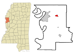
Leland, Mississippi — Infobox Settlement official name = Leland, Mississippi settlement type = City nickname = motto = imagesize = image caption = image imagesize = image caption = image mapsize = 250px map caption = Location of Leland, Mississippi mapsize1 = map… … Wikipedia
Leland High School (Leland, Mississippi) — infobox school name=Leland High School streetaddress=403 East Third Street city=Leland state=Mississippi zipcode=38756 country=USA phone=662 686 5020 principal=Jessie King grades=9 12 students=302 website=… … Wikipedia
Leland High School — may refer to:*Leland High School (San Jose, California) mdash; San Jose, California *Leland High School (Leland, Illinois) mdash; Leland, Illinois *Leland High School (Leland, Mississippi) mdash; Leland, MississippiIt may also refer to: *Leland… … Wikipedia
Leland — may refer to: Places ;Norway * Leland, Norway;United States * Leland, Illinois * Leland, Iowa * Leland, Louisiana * Leland, Michigan * Leland, Mississippi * Leland, North Carolina * Leland, Utah * Leland Grove, Illinois * Leland Township,… … Wikipedia
Leland — ist der Name folgender Orte in den Vereinigten Staaten: Leland (Illinois) Leland (Iowa) Leland (Louisiana) Leland (Michigan) Leland (Mississippi) Leland (North Carolina) Leland (Wisconsin) Leland Township (Leelanau County, Michigan) Leland River … Deutsch Wikipedia
Mississippi locations by per capita income — Mississippi is the poorest state in the United States of America, with a per capita income of $15,853 (2000). Mississippi Counties Ranked by Per Capita Income 1. Madison County $32,469 2. DeSoto County $20,468 3. Rankin County $20,412 4. Lee… … Wikipedia
Leland School District — The Leland School District is a public school district based in Leland, Mississippi (USA).chools*Leland High School *Leland Elementary School *Leland School ParkDemographics2006 07 school yearThere were a total of 1,127 students enrolled in the… … Wikipedia
Mississippi Blues Trail — Marker for Elvis birthplace in Tupelo, Mississippi[1] The Mississippi Blues Trail, created by the Mississippi Blues Commission, is a project to place interpretive markers at the most notable historical sites related to the growth of the blues… … Wikipedia
Leland — Leland, NC U.S. town in North Carolina Population (2000): 1938 Housing Units (2000): 919 Land area (2000): 4.005585 sq. miles (10.374417 sq. km) Water area (2000): 0.050214 sq. miles (0.130054 sq. km) Total area (2000): 4.055799 sq. miles… … StarDict's U.S. Gazetteer Places
Leland, MS — U.S. city in Mississippi Population (2000): 5502 Housing Units (2000): 2095 Land area (2000): 2.060556 sq. miles (5.336816 sq. km) Water area (2000): 0.025231 sq. miles (0.065349 sq. km) Total area (2000): 2.085787 sq. miles (5.402165 sq. km)… … StarDict's U.S. Gazetteer Places

