Manila International Airport

Manila International Airport
Flughafen Manila
Flughafen Manila (Philippinen)
DEC
Kenndaten
IATA-Code MNL
ICAO-Code RPLL
Koordinaten
Verkehrsanbindung
Entfernung vom Stadtzentrum 7 km südlich von Manila
Straße
Basisdaten
Eröffnung 1937
Betreiber MIAA
Fläche
Terminals 2
Passagiere 20.467.627
Luftfracht 388.551
Flug-
bewegungen
188.797
Start- und Landebahnen
06/24 3.737 m × 60 m Beton
13/31 2.258 m × 45 m Beton

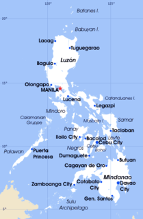
Der Ninoy Aquino International Airport (NAIA; Filipino: Pambansang Punong Rehiyon) ist ein 1937 gegründeter internationaler Flughafen in der Metro Manila im südostasiatischen Land Philippinen. Der größte Flughafen des Landes hat den IATA-Code MNL und den ICAO-Code RPLL.

Der 7 km südlich von Manila gelegene Flughafen fertigte im Jahr 2007 20.467.627 Passagiere ab.

Flughafenbetreiber ist die Behörde Manila International Airport Authority (MIAA), die zum Transportministerium DOTC gehört.

Infrastruktur

Der Flughafen weist folgende Flughafeninfrastruktur auf:

Er verfügt über zwei Start- bzw. Landebahnen, die jeweils betoniert sind und 3737 bzw. 2258 Meter lang sind. Neben drei bestehenden Terminals ( Terminal 1 und 2, Domestic Terminal) , gibt es ein viertes Terminal (NAIA 3). Dieses ist nachdem es seit Jahren zwar weitgehend fertiggestellt aber wegen Differenzen zwischen Investor und Regierung eingemottet war, provisorisch in Betrieb gegangen.

Das alte internationale Terminal 1 hat eine Größe von 67.000 m², das Terminal 2 hat eine Größe von 75.000 m². Letzteres wird ausschließlich durch die Philippine Airlines und Air Philippines verwendet. Der Inlandsverkehr (außer Philippine Airlines, Air Philippines und Cebu Pacific Air) wird aus einem separaten Terminal abgewickelt. Im NAIA 3 werden die Flüge von Cebu Pacific Air abgewickelt.

Einzelnachweise


Weblinks


Wikimedia Foundation.

Игры ⚽ Поможем сделать НИР

Schlagen Sie auch in anderen Wörterbüchern nach:

  • Manila International Airport LRT Station — Manila International Airport Station Rapid transit Station statistics Address Roxas Boulevard Tambo, Parañaque City Lines █ Yellow Line …   Wikipedia

  • Zamboanga International Airport — Paliparang Pandaigdig ng Zamboanga Aeropuerto Internacional de Zamboanga IATA: ZAM – ICAO: RPMZ …   Wikipedia

  • Ninoy Aquino International Airport — Paliparang Pandaigdig ng Ninoy Aquino Facade of NAIA Terminal 3 …   Wikipedia

  • Ninoy Aquino International Airport — Flughafen Manila …   Deutsch Wikipedia

  • Iloilo International Airport — Paliparang Pandaigdig ng Iloilo Pangkalibutan nga Hulugpaan sang Iloilo Exterior of Iloilo International Airport IATA: ILO – ICAO …   Wikipedia

  • Narita International Airport — 成田国際空港 Narita Kokusai Kūkō IATA: NRT – ICAO: RJAA …   Wikipedia

  • Macau International Airport — Infobox Airport name = Macau International Airport nativename = pt. Aeroporto Internacional de Macau nativename a = 澳門國際機場 image width = 250 IATA = MFM ICAO = VMMC type = Public operator = Sociedade do Aeroporto Internacional de Macau S.A.R.L.… …   Wikipedia

  • Honolulu International Airport — Infobox Airport name = Honolulu International Airport IATA = HNL ICAO = PHNL FAA = HNL type = Public / Military owner = State of Hawaii operator = Department of Transportation city served = location = Honolulu, Hawaii elevation f = 13 elevation m …   Wikipedia

  • Kaohsiung International Airport — Infobox Airport name = Kaohsiung International Airport nativename = nativename a = 高雄國際機場 nativename r = image width = caption = IATA = KHH ICAO = RCKH type = Public owner = operator = Civil Aeronautics Administration city served = Kaohsiung… …   Wikipedia

  • Kansai International Airport — 関西国際空港 Kansai Kokusai Kūkō …   Wikipedia

Share the article and excerpts

Direct link
Do a right-click on the link above
and select “Copy Link”