Maryland County

Maryland County
Maryland
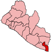
Basisdaten
Hauptstadt Harper
Fläche 5.351 km²
Einwohner 85.000 (kein Jahr angegeben)
Bevölkerungsdichte 15,9 Einwohner pro km²
ISO 3166-2 LR-MY

Maryland ist eine Verwaltungsregion (County) Liberias mit etwa 85.000[1] (nach anderen Angaben 107.000) Einwohnern. Ihre Hauptstadt ist Harper.

Maryland liegt im äußersten Südosten Liberias am Atlantik und an der Grenze zur Elfenbeinküste.

Etwa 80 % der Bevölkerung sind in der Landwirtschaft tätig, Hauptanbauprodukte sind Reis und Maniok.

Die Flagge von Maryland[2] zeigt zwischen zwei horizontalen gelben Streifen einen Baum und einen Leuchtturm auf einer grünen Klippe.

Geschichte

Gegründet wurde Maryland 1834. Im Jahr 1857 wurde die bis dahin selbständige Republik Maryland als Provinz Maryland in die Republik Liberia aufgenommen.

Quellen

  1. statoids.com
  2. Flags of the World

Wikimedia Foundation.

Игры ⚽ Поможем написать курсовую

Schlagen Sie auch in anderen Wörterbüchern nach:

  • Maryland County —   County   Location in Liberia Coordinates …   Wikipedia

  • Maryland county executive elections, 2010 — Elections in Maryland Federal government Presidential Election …   Wikipedia

  • Maryland county executive elections, 2006 — Elections in Maryland Federal government Presidential Electio …   Wikipedia

  • Maryland county offices elections, 2006 — Elections in Maryland Federal government Presidential Electio …   Wikipedia

  • Maryland county offices elections, 2010 — Elections in Maryland Federal government Presidential Electio …   Wikipedia

  • Maryland City, Maryland —   CDP   …   Wikipedia

  • Maryland Line, Maryland — Maryland Line   Unincorporated town   …   Wikipedia

  • Maryland (disambiguation) — Maryland may refer to: Places Maryland, the U.S. state Province of Maryland, the U.S. state when it was an English colony Maryland, New York, United States, a town Maryland Heights, Missouri, United States Maryland, London, an area of Newham,… …   Wikipedia

  • Maryland LiDAR Availability — Maryland is among the states in the US that is acquiring LIDAR data, complementing the National LIDAR Dataset USA effort to acquire high resolution elevation data across the nation. The Maryland Dept. of Natural Resources coordinates with most… …   Wikipedia

  • Maryland State Colonization Society — Constitution and Laws of Maryland in Liberia, published by the Maryland State Colonization Society, 1847 The Maryland State Colonization Society was the Maryland branch of the American Colonization Society, an organization founded in 1816 with… …   Wikipedia

Share the article and excerpts

Direct link
Do a right-click on the link above
and select “Copy Link”