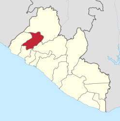
- Gbarpolu
-
Gbarpolu 
Basisdaten Staat Liberia Hauptstadt Bopolu Fläche 9.689 km² Einwohner 83.388 (2008) Dichte 8,6 Einwohner pro km² Gründung 2001 ISO 3166-2 LR-GP 7.1666666666667-10.416666666667Koordinaten: 7° 10′ N, 10° 25′ WGbarpolu ist eine Verwaltungsregion (County) in Liberia, sie hat eine Größe von 9.689 km² und besaß bei der letzten Volkszählung (2008) 83.388 Einwohner.[1]
Die Verwaltungsregion untergliedert sich in sechs Districte.
Die Hauptstadt ist Bopolu im gleichnamigen District.[2]District Ew (2008)
männlichEw (2008)
weiblichEw (2008)
GesamtBelleh 7.951 7.306 15.257 Bokomu 4.386 5.171 9.557 Bopolu 9.580 8.139 17.719 Gbarma 8.781 7.070 15.851 Gounwolaila 5.608 5.904 11.512 Kongba 7.600 5.892 13.492 Gbarpolu 43.906 39.482 83.388 Gbarpolu liegt im Nordwesten des Landes und grenzt mit dem District Kongba an Sierra Leone.
Inhaltsverzeichnis
Wirtschaft
Vor dem Bürgerkrieg in Liberia gründete sich die Wirtschaft in Gbarpolu neben Subsistenz-Landwirtschaft hauptsächlich auf den Bergbau.
Politik
Bei den ersten demokratischen Senatswahlen nach dem Bürgerkrieg wurde Daniel Flomo Naatehn von der UP gewählt. Im Jahr 2007 wurde bei einer erforderlichen Nachwahl J.S.B. Theodore Momo - ebenfalls UP - gewählt.[3]
Weblinks
- Couty Development Agenda (2008-2012) - aktuelle Schwerpunkte der Entwicklung (PDF, 2.7 MB, englisch)
Quellen
- ↑ NPHC 2008 Report Final. In: Liberian Institut of Statistics and Geo-Information-Systems (LISGIS). Abgerufen am 11. Oktober 2010. (pdf, englisch, 1.4 MB) Endergebnisse der Volkszählung von 2008
- ↑ Liberia, Counties and Districts. In: Liberian Institut of Statistics and Geo-Information-Systems (LISGIS). Abgerufen am 11. Oktober 2010. (pdf, englisch, 0.4 MB) Übersichtskarte
- ↑ en:Wiki, Artikel »Liberian general election, 2005« (die dort verlinkten Webseiten zur Wahl sind nicht mehr präsent).
Verwaltungsgliederung LiberiasBomi | Bong | Gbarpolu | Grand Bassa | Grand Cape Mount | Grand Gedeh | Grand Kru | Lofa | Margibi | Maryland | Montserrado | Nimba | River Cess | River Gee | Sinoe
Wikimedia Foundation.
