Mbomou

Mbomou
Mbomou
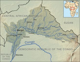
Einzugsgebiet des Ubangi mit dem Mbomou (Mitte rechts)

Einzugsgebiet des Ubangi mit dem Mbomou (Mitte rechts)

DatenVorlage:Infobox Fluss/GKZ_fehlt
Lage Zentralafrikanische Republik, Demokratische Republik Kongo
Flusssystem Kongo

Vorlage:Infobox Fluss/ABFLUSSWEG_fehlt

Quellgebiet Zentralafrikanische Republik an der Grenze zum SudanVorlage:Infobox Fluss/QUELLKOORDINATE_fehltVorlage:Infobox Fluss/QUELLHÖHE_fehlt
Mündung Im Grenzbereich zwischen der Demokratische Republik Kongo und Zentralafrikanische Republik in den Ubangi
4.126388888888922.431944444444

4° 7′ 35″ N, 22° 25′ 55″ O4.126388888888922.431944444444
Vorlage:Infobox Fluss/MÜNDUNGSHÖHE_fehltVorlage:Infobox Fluss/HÖHENUNTERSCHIED_fehlt
Länge 800 kmVorlage:Infobox Fluss/NACHWEISE_fehlenVorlage:Infobox Fluss/EINZUGSGEBIET_fehlt

Vorlage:Infobox Fluss/ABFLUSS_fehlt

Rechte Nebenflüsse Mbari; Chinko; Ouara
Linke Nebenflüsse Bili
Mittelstädte BangassouVorlage:Infobox Fluss/BILD_fehlt

Der Mbomou (gelegentlich als Bomu) ist ein Fluss in Zentralafrika. Er vereinigt sich mit dem Uele und bildet ab dem Zusammenfluss den Ubangi, einen der großen Zuflüsse des Kongo. Der Mbomou bildet in seinem Gesamtverlauf die Staatsgrenze zwischen der Zentralafrikanischen Republik und der Demokratischen Republik Kongo.


Wikimedia Foundation.

Игры ⚽ Нужен реферат?

Schlagen Sie auch in anderen Wörterbüchern nach:

  • Mbomou — (o Bomu ) es una de las 14 prefecturas de la República Centroafricana. Está situada en el sureste del país, junto con la República Democrática del Congo. Su capital es Bangassou. Linda con las prefecturas de Basse Kotto al oeste, Haute Kotto al… …   Enciclopedia Universal

  • Mbomou — (le) rivière (750 km) qui sépare le S. E. de la Rép. centrafricaine et la rép. dém. du Congo. Né au Soudan, il coule d E. en O. et conflue avec le Uélé pour former l Oubangui …   Encyclopédie Universelle

  • Mbomou — 4° 07′ 35″ N 22° 25′ 55″ E / 4.12639, 22.4319 …   Wikipédia en Français

  • Mbomou — can also refer to the Mbomou River. Mbomou is one of the 14 prefectures of the Central African Republic. It covers an area of 61,150 km² and has a population of 132,740 (2003 census), giving a population density of only 2.2 inhabitants/km². The… …   Wikipedia

  • Mbomou — Prefuctura de Mbomou Mapa Datos básicos País …   Wikipedia Español

  • Mbomou — Admin ASC 1 Code Orig. name Mbomou Country and Admin Code CF.08 CF …   World countries Adminstrative division ASC I-II

  • Mbomou (Präfektur) — Mbomou Basisdaten Hauptstadt: Bangassou Fläche …   Deutsch Wikipedia

  • Mbomou River — Map showing the Mbomou River within the Ubangi River drainage basin. The Mbomou River or Bomu (also spelled M bomou in French) forms part of the boundary between the Central African Republic (CAR) and the Democratic Republic of the Congo (DRC).… …   Wikipedia

  • Mbomou (préfecture) — 5°00′N 23°30′E / 5, 23.5 …   Wikipédia en Français

  • Mbomou (homonymie) — Cette page d’homonymie répertorie les différents sujets et articles partageant un même nom. Mbomou peut désigner : Mbomou ou Bomu, un cours d eau d Afrique Mbomou, une préfecture de République centrafricaine Haut Mbomou, une préfecture de… …   Wikipédia en Français

Share the article and excerpts

Direct link
Do a right-click on the link above
and select “Copy Link”