Moimi

Moimi
Talbot-Inseln
Lage der Torres-Strait-Inseln
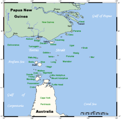
Gewässer Pazifischer Ozean
Anzahl der Inseln 11 (3 Hauptinseln)
Hauptinsel Boigu
Gesamtfläche 72,3dep1
Einwohner 270
Geographische Lage 9° 15′ S, 142° 13′ O-9.2569694444444142.218757Koordinaten: 9° 15′ S, 142° 13′ O
Talbot-Inseln (Australien)
DEC
Talbot-Inseln

Die Talbot-Inseln sind eine australische Inselgruppe im Archipel der Torres-Strait-Inseln. Sie liegen nur 5 km vor der Südküste von Papua-Neuguinea in Höhe der Mündung des Mai Kussa und gelten damit als die nördlichste bewohnte Inselgruppe Australiens (Queensland).

Zu den Talbot-Inseln gehören einige kleine Inseln sowie die 72 km² große Hauptinsel Boigu:

Insel Fläche
km²
Geokoordinate
Boigu 72,3 9° 15′ 44″ S, 142° 12′ 51″ O-9.2623055555556142.214297222227
Moimi 2,1 9° 13′ 45″ S, 142° 14′ 29″ O-9.2290722222222142.241357
Abussi 5,8 9° 14′ 4″ S, 142° 10′ 13″ O-9.2344055555556142.170208333337
Aymermud 0,7
unbenannt (Aymermud/Moegina Kawa) 0,03 9° 13′ 51″ S, 142° 9′ 9″ O-9.2306972222222142.152605555567
Moegina Kawa 0,4
unbenannt (n. von Moegina Kawa) 0,2

Nur die Hauptinsel Boigu ist bewohnt, mit einer Bevölkerung von 270 Einwohnern.

Verwaltungsmäßig zählt die Inselgruppe zu den Top Western Islands, einer Inselregion im Verwaltungsbezirk Torres Shire von Queensland.

Siehe auch

Weblinks


Wikimedia Foundation.

Игры ⚽ Нужно сделать НИР?

Schlagen Sie auch in anderen Wörterbüchern nach:

  • Territorial waters — Schematic map of maritime zones. Territorial waters, or a territorial sea, as defined by the 1982 United Nations Convention on the Law of the Sea,[1] is a belt of coastal waters extending at most 12 nautical miles (22 km; 14 mi) from… …   Wikipedia

  • Boigu — Island Landsat Bild von Boigu (Bildmitte), mit Moimi im Nordosten und Aubusi im Nordwesten …   Deutsch Wikipedia

  • mój — + moja (ma), moje (me) D. m n mojego (mego), ż mojej (mej), C. m n mojemu (memu), ż mojej (mej), B. m=D. a. M., n=M., ż moją (mą), N. m n moim (mym), ż moją (mą), Ms. m n moim (mym), ż mojej (mej); lm M. m. os. moi, ż. rzecz. moje (me), D. moich… …   Słownik języka polskiego

  • Boigu Island (Queensland) — Boigu Island (coord|9|16|S|142|13|E|region:AU QLD type:isle|display=inline,title) is the most northerly inhabited island in Australian territory. It is part of the top western group of the Torres Strait Islands, which lie in the Torres Strait… …   Wikipedia

  • Talbot Islands (Queensland) — Talbot Islands are a group of Torres Strait Islands in Australia, between the Australian mainland and the island of New Guinea and a few kilometres West of Saibai Island, Torres Strait only 4 km from the Papua New Guinea mainland. Talbot Islands… …   Wikipedia

  • List of Torres Strait Islands — Map of all coordinates from Google Map of all coordinates from Bing Export all coordinates as KML …   Wikipedia

  • Kazimierz Majdanski — Kazimierz Jan Majdański (* 1. März 1916 in Małgów bei Kalisz; † 29. April 2007 in Warschau) war ein römisch katholischer Theologe und Erzbischof von Stettin Cammin. Er gilt als einer der ersten und profiliertesten Brückenbauer der deutsch… …   Deutsch Wikipedia

  • Kazimierz Majdański — Kazimierz Jan Majdański (* 1. März 1916 in Małgów bei Kalisz; † 29. April 2007 in Warschau) war ein römisch katholischer Theologe und Erzbischof von Stettin Cammin. Er gilt als einer der ersten und profiliertesten Brückenbauer der deutsch… …   Deutsch Wikipedia

  • Liste von Torres-Strait-Inseln — Karte der Torres Strait Inseln Die Torres Strait Inseln sind eine Gruppe von 274 kleinen Inseln in der Meerespassage (Torres Straße) zwischen der Nordspitze Australiens, dem Kap York, und Papua Neuguinea. Die überwiegende Anzahl der Inseln gehört …   Deutsch Wikipedia

  • Talbot-Inseln — Landsat Bild der Inselgruppe Gewässer Pazifischer Ozean …   Deutsch Wikipedia

Share the article and excerpts

Direct link
Do a right-click on the link above
and select “Copy Link”