Moine Thrust

Moine Thrust
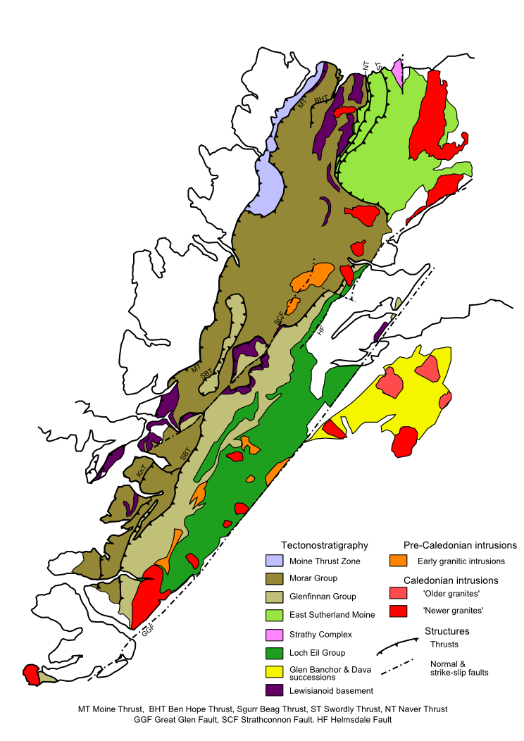
Geologische Karte Südschottlands mit dem Moine Thrust (MT) als nordwestliche Begrenzung

Moine Thrust ist eine geologische Decken-Überschiebung im Norden Schottlands. Sie ist etwa 180 km lang und reicht vom Süden der Isle of Skye bis zum Loch Eriboll in Nordost-Sutherland. Der Name ist abgeleitet von a'Mhoine, die Bezeichnung für Moor in Nord-Sutherland.[1]

Der Moine Thrust entstand vor 410 bis 430 Millionen Jahren während der kaledonischen Gebirgsbildung durch die Überschiebung von europäischer auf amerikanische Kruste. Die Überschiebungszone ist mehrere Kilometer breit und trennt einen tektonisch erkennbar beanspruchten metamorphen Gneis (Lewisian Gneiss) von den ihn überlagenden Sedimenten der neoproterozoischen Moine Supergroup im Südosten von den neoproterozoischen und kambro-ordovizischen Gesteinen im Nordwesten.

Der Moine Thrust wurde 1907 als erster Überschiebungsgürtel überhaupt identifiziert.[2]

Weblinks

Einzelnachweise

  1. R.J. Howarth & B.E. Leake: The life of Frank Coles Phillips (1902-1982) and the Structural Geology of the Moine Petrofabric Controversy. In: Geological Society London Memoir. 23, 2002 (Online).
  2. B.N. Peach, J. Horne, W. Gunn, C.T. Clough, L.W. Hinxman und J.J.H. Teall: The geological structure of the NW Highlands of Scotland. In: Memoirs of the Geological Survey of Great Britain. 1907, S. 653.

Wikimedia Foundation.

Игры ⚽ Нужно сделать НИР?

Schlagen Sie auch in anderen Wörterbüchern nach:

  • Moine Thrust Belt — defining the western edge of the Moine Supergroup outcrop The Moine Thrust Belt is a linear geological feature in the Scottish Highlands which runs from Loch Eriboll on the north coast 190 km south west to the Sleat peninsula on the Isle of… …   Wikipedia

  • Thrust fault — in the Qilian Shan, China. The older (left, blue and red) thrust over the younger (right, brown). A thrust fault is a type of fault, or break in the Earth s crust across which there has been relative movement, in which rocks of lower… …   Wikipedia

  • MOINE (CHARRIAGE DU) — MOINE CHARRIAGE DU ou MOINE THRUST Le charriage du Moine (ou Moine thrust des géologues anglo saxons) est un grand accident chevauchant situé au nord de l’Écosse, orienté du nord nord est au sud sud ouest. Il met en contact anormal les roches du… …   Encyclopédie Universelle

  • Moine — is the French word for Monk. It can also stand for: Contents 1 Geography 2 Geology 3 People 4 Miscellaneous Geography …   Wikipedia

  • Moine — bezeichnet: einen Fluss in Frankreich, Nebenfluss der Sèvre Nantaise, siehe Moine (Fluss) eine französische Gemeinde im Département Maine et Loire, siehe Saint Crespin sur Moine eine französische Gemeinde im Département Maine et Loire, siehe… …   Deutsch Wikipedia

  • Moine Supergroup — Map of the distribution of the Moine Supergroup on Mainland Scotland and the Inner Hebrides The Moine Supergroup is a sequence of Neoproterozoic metamorphic rocks that form the dominant outcrop of the Scottish Highlands between the Moine Thrust… …   Wikipedia

  • North West Highlands Geopark — Knockan Crag The North West Highlands Geopark is a geopark in the Scottish Highlands. Awarded UNESCO geopark status in 2004,[1] it features some of the oldest rocks in Europe, around 3,000 million years old …   Wikipedia

  • Geology of Scotland — The geology of Scotland is unusually varied for a country of its size, with a large number of differing geological features. [Keay Keay (1994) op cit page 415.] There are three main geographical sub divisions: the Highlands and Islands is a… …   Wikipedia

  • Durness — Coordinates: 58°34′N 4°45′W / 58.57°N 4.75°W / 58.57; 4.75 …   Wikipedia

  • Knockan Crag — Centro de visitantes de Knockan Crag. L …   Wikipedia Español

Share the article and excerpts

Direct link
Do a right-click on the link above
and select “Copy Link”