Morley (West Yorkshire)

Morley (West Yorkshire)
Morley
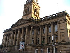
Morley Town Hall
Morley Town Hall
Koordinaten 53° 45′ N, 1° 36′ W53.7477-1.6027Koordinaten: 53° 45′ N, 1° 36′ W
Morley (England)
Morley
Morley
Bevölkerung 23.738 2001
Verwaltung
Post town LEEDS
Postleitzahlen­abschnitt LS27
Vorwahl 0113
Landesteil England
Region Yorkshire and the Humber
Metropolitan county West Yorkshire
Metropolitan Borough City of Leeds
Civil parish Morley
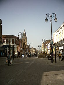
Queen Street

Morley ist eine Stadt mit 54.051 Einwohnern (Stand: 2001) in West Yorkshire in Mittelengland und befindet sich rund 8 km südwestlich von Leeds im Leeds Metropolitan Borough. Das Metropolitan County West Yorkshire wurde 1974 gebildet, vorher war Morley Teil der Grafschaft Yorkshire. Durch Morley verläuft die Autobahn M 62 Hull-Manchester

Morley wurde ebenso wie Rom auf sieben Hügeln errichtet: Scatcherd Hill, Dawson Hill, Daisy Hill, Chapel Hill, Hunger Hill, Troy Hill und Banks Hill. In der Stadt ist traditionell das Textilgewerbe zu Hause. So wurden hier vor allem Shoddy-Waren verarbeitet. Bedeutendstes Gebäude der Stadt ist das Rathaus mit seinem Glockenturm. Morley ist seit 1878 Heimat eines Rugby-Clubs, der vor allem in den 1970er Jahren Erfolge feierte.

Die Stadt geriet in die Schlagzeilen, nachdem hier ein Mitglied der neofaschistischen British National Party in den Stadtrat gewählt wurde; außerdem hielt im Jahre 2004 der BNP-Vorsitzende Nick Griffin in der Stadt eine Rede, die als rassistisch gewertet wurde.

Zu den bedeutendsten Persönlichkeiten der Stadt zählen:

  • Sir Titus Salt (1803-1876), Gründer der Gemeinde Saltaire
  • Herbert Henry Asquith (1852-1928), britischer Premierminister
  • Ernie Wise (1925-1999), Komiker
  • Beryl Burton (1937-1996), Radrennfahrerin
  • Helen Fielding (* 1958), Schriftstellerin
  • Leigh Francis (* 1973), Komiker

Partnerstadt von Morley ist die deutsche Stadt Siegen.

Weblinks

 Commons: Morley, West Yorkshire – Sammlung von Bildern, Videos und Audiodateien
Straßenkarte von Morley

Wikimedia Foundation.

Игры ⚽ Поможем решить контрольную работу

Schlagen Sie auch in anderen Wörterbüchern nach:

  • Morley, West Yorkshire — Coordinates: 53°44′57″N 1°36′08″W / 53.749166°N 1.602263°W / 53.749166; 1.602263 …   Wikipedia

  • West Yorkshire Passenger Transport Executive — Type Passenger Transport Executive Industry Public transport Founded 1974 (Local Go …   Wikipedia

  • West Yorkshire — Geografie Status: Zeremonielle Grafschaft Region: Yorkshire and the Humber Fläche: 2.209 km² Demografie …   Deutsch Wikipedia

  • West Yorkshire Urban Area — The West Yorkshire Urban Area is a term used by the Office for National Statistics (ONS) to refer to a conurbation in West Yorkshire, England, based mainly on Leeds, Bradford, Huddersfield, Wakefield, but excluding towns such as Castleford,… …   Wikipedia

  • West Yorkshire Police — Infobox UK Police name= West Yorkshire Police area= West Yorkshire start= 1974 (merger) population= 2,108,000 size= 2,029 km² officers= 5,671 title= Chief Constable head= Sir Norman Bettison divname= Divisions divno= 9 stations= 41 HQ= Wakefield… …   Wikipedia

  • West Yorkshire Fire and Rescue Service — Infobox UK Fire and Rescue name= West Yorkshire Fire and Rescue Service area= West Yorkshire start= 1974 population= 2,000,000 size= 800 miles² staff= 1,915 BM= Phil Toase stations= 48 HQ= Birkenshaw, Bradford FA= West Yorkshire Fire and Rescue… …   Wikipedia

  • Halifax, West Yorkshire — For other uses, see Halifax. Coordinates: 53°43′30″N 1°51′47″W / 53.725°N 1.863°W / 53.725; 1.863 …   Wikipedia

  • Middleton, West Yorkshire — infobox UK place country = England official name= Middleton map type= West Yorkshire latitude= 53.7428 longitude= 1.5526 population = metropolitan borough= City of Leeds metropolitan county= West Yorkshire region= Yorkshire and the Humber… …   Wikipedia

  • Normanton, West Yorkshire — Coordinates: 53°41′49″N 1°24′58″W / 53.697°N 1.416°W / 53.697; 1.416 …   Wikipedia

  • Carlton, West Yorkshire — infobox UK place country = England official name = Carlton latitude = 53.740000 longitude = 1.490200 static static image caption = Village sign showing rhubarb, with rhubarb plants in foreground population = 169 civil parish = Carlton… …   Wikipedia

Share the article and excerpts

Direct link
Do a right-click on the link above
and select “Copy Link”