Nembra

Nembra

Vorlage:Infobox Gemeinde in Spanien/Wartung/kein cod_ine

Gemeinde Aller: Parroquia Nembra
Wappen Karte von Spanien
Wappen fehlt
Hilfe zu Wappen
Nembra (Spanien)
Ajoneuvolla ajo kielletty 311.svg
Basisdaten
Autonome Gemeinschaft: Asturien
Provinz: Asturien
Comarca: Caudal
Koordinaten 43° 9′ N, 5° 42′ W43.14825-5.70593194Koordinaten: 43° 9′ N, 5° 42′ W
Höhe: 194 msnm
Fläche: 22,2 km²
Einwohner: 404 (2008)
Bevölkerungsdichte: 18,2 Einw./km²
Postleitzahl: 33677
Nächster Flughafen: Flughafen Asturias 85,3 km
Verwaltung
Bürgermeister: Modesto González González
Adresse der Gemeindeverwaltung: Constitucion, 1 (Cabañaquinta) 33686 ALLER
Webpräsenz der Gemeinde
Lage der Gemeinde
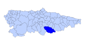
Ayer Asturies map.svg

Nembra ist eines von 18 Parroquias in der Gemeinde Aller der autonomen Region Asturien in Spanien.

Inhaltsverzeichnis

Geographie

Nembra hat 404 Einwohner (2008) und eine Fläche von 22,20 km². Es liegt auf 410 m über dem Meeresspiegel. Die höchste Erhebung ist der Berg La Boya mit 1.731 m. Die Spuren des Ortes gehen zurück bis in das Jahr 26 n. Chr. Nembra umfasst die Ortsteile, Dörfer und Weiler Arnizo, Cabanón, Cabo, La Campueta, La Carrera, La Corralada,El Otero, Enfistiella, Fresnadiello, Fureras, Los Heros, Huertomuro, Omedal, Perasente, Posadorio, Pumardongo, Rueda, San Miguel und Los Tornos.

Der Fluss, der Nembra durchfließt (Río Negro), ist bekannt für seine ausgezeichneten Forellen.

Dörfer und Weiler

  • Vatchosera
  • La Enfistietcha
  • El Otero
  • El Campu
  • La LLera
  • San Miguel

Fiesta

  • 1. - 7. August Stadtfest (zu Ehren des Hl. Dominikus)

Sehenswürdigkeiten

Quellen

  • Bevölkerungszahlen siehe INE
  • Postleitzahlen siehe [1]
  • Koordinaten und Entfernungs- Höhenangaben siehe Google Earth

Wikimedia Foundation.

Игры ⚽ Нужно решить контрольную?

Schlagen Sie auch in anderen Wörterbüchern nach:

  • Nembra — Parroquia de España Entidad Parroquia  • País …   Wikipedia Español

  • Nembra — is one of 18 parishes (administrative divisions) in Aller, a municipality within the province and autonomous community of Asturias, in northern Spain. The altitude 410 m (1,350 ft) above sea level. It is 22.2 km2… …   Wikipedia

  • Nembra — es una parroquia del concejo asturiano de Aller, en España. En sus 22,2 km² habitan un total de 466 personas (2004) repartidas entre las poblaciones de Arnizo, Cabanón, Cabo, La Campueta, La Carrera, La Corralada,El Otero, Enfistiella,… …   Enciclopedia Universal

  • Villetta Nembra — (Edolo,Италия) Категория отеля: Адрес: Via Nembra 2, 25048 Edolo, Италия …   Каталог отелей

  • Cthulhu Mythos deities — Writer H.P. Lovecraft created a number of fictional beings throughout the course of his literary career, including the Great Old Ones and the Outer Gods. The Elder Gods are a later creation of writer such as August Derleth, who is credited with… …   Wikipedia

  • Aller (Spanien) — Aller / Ayer Wappen Karte von Spanien …   Deutsch Wikipedia

  • Aller, Asturias — Infobox Asturian municipality coat of arms= Aller.jpg coat of arms size= 80px othername= Ayer demonym Spanish= allerano, allerana capital= Cabañaquinta coordinates = coord|43|20|N|4|42|W judicial district= Lena parishes= 18 year= 2005 population …   Wikipedia

  • Otero — steht für : Otero (Familienname), galizischer Familienname (1126) Otero, Asteroid des Hauptgürtels Otero bezeichnet: Otero (Toledo), eine Gemeinde in der Provinz Toledo, Spanien Otero ist Bestandteil des Namens folgender geographischer Orte… …   Deutsch Wikipedia

  • Aller (Espagne) — Pour les articles homonymes, voir Aller. Localisation de Aller Aller (Ayer en asturien) est une commune dans le sud des Asturies dont la bourgade principale est …   Wikipédia en Français

  • Aller - Asturies (Rio Aller - consejo de Aller) — Aller (Espagne) Pour les articles homonymes, voir Aller. Localisation de Aller Aller (Ayer en asturien ) est une commune dans le sud des …   Wikipédia en Français

Share the article and excerpts

Direct link
Do a right-click on the link above
and select “Copy Link”