- Pili (Camarines Sur)
-
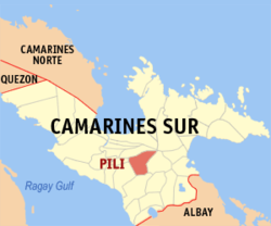
Pili (Camarines Sur) Lage von Pili in der Provinz Camarines Sur 
Basisdaten Bezirk: Bicol-Region Provinz: Camarines Sur Barangays: 26 PSGC: 051728000 Einkommensklasse: 1. Einkommensklasse Haushalte: Zensus 1. Mai 2000Einwohnerzahl: 76.496 Zensus 1. August 2007Koordinaten: 13° 35′ N, 123° 18′ O13.583333333333123.3Koordinaten: 13° 35′ N, 123° 18′ O Bürgermeister: Tom Bongalonta Jr. Offizielle Webpräsenz: www.pili.gov.ph Geographische Lage auf den Philippinen Pili ist eine philippinische Stadtgemeinde in der Provinz Camarines Sur. Es wird Bikolano, Filipino/Tagalog, und Englisch gesprochen.
Die Stadtgemeinde Pili liegt zentral in der Provinz Camarines Sur auf der Insel Luzon.Die Stadtgemeinde Pili grenzt im Norden an die Gemeinde Naga City, im Süden an die Gemeinde Bula, im Osten an Ocampo, im Westen an die Gemeinden Minalabac und Milaor Die Stadtgemeinde von Pili besteht aus 26 Barangays.
Barangays
Die Stadtgemeinde Pili ist unterteilt in 26 Barangays:
Barangay Einwohner Haushalte Anayan 2.523 436 Bagong Sirang 2.203 416 Binanwaanan 2.843 554 Binobong 1.826 326 Cadlan 4.136 642 Caroyroyan 3.099 556 Curry 2.210 443 Del Rosario 2.426 456 Himaao 3.622 673 La Purisima 2.305 460 New San Roque 2.323 432 Old San Roque 1.325 234 Palestina 4.140 783 Pawili 1.286 238 Sagurong 2.102 394 Sagrada 2.036 377 San Augustin 4.298 745 San Antonio 1.168 207 San Isidro 1.821 353 San Jose 8.107 1.565 San Juan 1.659 321 San Vicente 2.085 385 Santiago 2.316 418 Santo Niño 1.117 205 Tagbong 2.414 453 Tinangis 2.000 327 Weblinks
- Offizielle Homepage von Pili (englisch)
Quellen
- www.pili.gov.ph (englisch)
- www.nscb.gov.ph (englisch)
Städte und Stadtgemeinden in der Provinz Camarines SurStädte: Iriga City | Naga City
Stadtgemeinden: Baao | Balatan | Bato | Bombon | Buhi | Bula | Cabusao | Calabanga | Camaligan | Canaman | Caramoan | Del Gallego | Gainza | Garchitorena | Goa | Lagonoy | Libmanan | Lupi | Magarao | Milaor | Minalabac | Nabua | Ocampo | Pamplona | Pasacao | Pili | Presentacion | Ragay | Sagñay | San Fernando | San Jose | Sipocot | Siruma | Tigaon | Tinambac
Wikimedia Foundation.
Schlagen Sie auch in anderen Wörterbüchern nach:
Pili, Camarines Sur — For Battle at Pili Camarines Sur see Battle at Pili. Infobox Philippine municipality infoboxtitle = Municipality of Pili sealfile = locatormapfile = Ph locator camarines sur pili.png| caption = Map of Camarines Sur showing the location of Pili… … Wikipedia
Camarines Sur (Provinz) — Lage der Provinz Camarines Sur Camarines Sur ist eine Provinz der Philippinen im Bezirk V, welcher sich auf der Insel Luzon befindet. Die Hauptstadt der Provinz ist Pili. Camarines Sur ist mit 5267 km² die größte Provinz des Bezirkes. Insgesamt… … Deutsch Wikipedia
Camarines Sur — Lage der Provinz Camarines Sur Camarines Sur ist eine Provinz der Philippinen im Bezirk V, die sich im Südosten der Insel Luzon befindet. Die Hauptstadt der Provinz ist Pili. Camarines Sur ist mit 5267 km² die größte Provinz des Bezirkes.… … Deutsch Wikipedia
Camarines Sur — Saltar a navegación, búsqueda Provincia de Camarines Sur … Wikipedia Español
Camarines Sur — Infobox Philippine province name = Camarines Sur sealfile = Ph seal camarines sur.png region = Bicol Region (Region V) capital = Pili founded = mdash; pop2000 = 1,693,821 (2007) pop2000rank = 15th largest popden2000 = 295 popden2000rank = 22nd… … Wikipedia
Camarines Sur — 13° 40′ 00″ N 123° 19′ 59″ E / 13.6667, 123.333 … Wikipédia en Français
Naga, Camarines Sur — City of Naga Ciudad nin Naga Lungsod ng Naga Seal Nickname(s) … Wikipedia
Ocampo, Camarines Sur — Ocampo Municipality Map of Camarines Sur showing the location of Ocampo … Wikipedia
Nabua, Camarines Sur — Nabua Municipality Seal … Wikipedia
Magarao, Camarines Sur — Magarao Municipality Map of Camarines Sur showing the location of Magarao … Wikipedia

