- Lagonoy
-
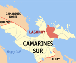
Municipality of Lagonoy Lage von Lagonoy in der Provinz Camarines Sur Basisdaten Bezirk: Bicol-Region Provinz: Camarines Sur Barangays: 38 Distrikt: 3. Distrikt von Camarines Sur PSGC: 051717000 Einkommensklasse: 3. Einkommensklasse Haushalte: 8135 Zensus 1. Mai 2000Einwohnerzahl: 46.093 Zensus 1. August 2007Koordinaten: 13° 44′ N, 123° 31′ O13.733333333333123.51666666667Koordinaten: 13° 44′ N, 123° 31′ O Postleitzahl: 4425 Bürgermeister: Delfin Pilapil Geographische Lage auf den Philippinen Lagonoy ist eine philippinische Stadtgemeinde in der Provinz Camarines Sur. Nach dem Zensus vom 1. Mai 2000 hat sie 42.636 Einwohner in 8135 Haushalten.
Baranggays
Lagonoy ist politisch in 38 Baranggays unterteilt.
- Agosais
- Agpo-Camagong-Tabog
- Amoguis
- Bocogan
- Balaton
- Binanuahan
- Burabod
- Cabotonan
- Dahat
- Del Carmen
- Ginorangan (Genorangan)
- Gimagtocon
- Gubat
- Guibahoy
- Himanag
- Kinahologan
- Loho
- Manamoc
- Mangogon
- Mapid
- Olas
- Omalo
- Panagan
- Panicuan
- Pinamihagan
- San Francisco (Pob.)
- San Isidro
- San Isidro Sur (Pob.)
- San Isidro Norte (Pob.)
- San Rafael
- San Ramon
- San Roque
- San Sebastian
- San Vicente (Pob.)
- Santa Cruz (Pob.)
- Santa Maria (Pob.)
- Saripongpong (Pob.)
- Sipaco
Städte und Stadtgemeinden in der Provinz Camarines SurStädte: Iriga City | Naga City
Stadtgemeinden: Baao | Balatan | Bato | Bombon | Buhi | Bula | Cabusao | Calabanga | Camaligan | Canaman | Caramoan | Del Gallego | Gainza | Garchitorena | Goa | Lagonoy | Libmanan | Lupi | Magarao | Milaor | Minalabac | Nabua | Ocampo | Pamplona | Pasacao | Pili | Presentacion | Ragay | Sagñay | San Fernando | San Jose | Sipocot | Siruma | Tigaon | Tinambac
Wikimedia Foundation.
Schlagen Sie auch in anderen Wörterbüchern nach:
Lagonoy — Original name in latin Lagonoy Name in other language Lagonoy State code PH Continent/City Asia/Manila longitude 13.7342 latitude 123.5207 altitude 15 Population 7324 Date 2011 07 31 … Cities with a population over 1000 database
Lagonoy Gulf — is a large gulf in the southeastern part of Luzon island, Philippines, at coord|13.5833333|N|123.75|E|. It is separated from the Philippine Sea by Caramoan Peninsula in the north … Wikipedia
Lagonoy, Camarines Sur — Infobox Philippine municipality infoboxtitle = Municipality of Lagonoy sealfile = locatormapfile = Ph locator camarines sur lagonoy.png| caption = Map of Camarines Sur showing the location of Lagonoy region = Bicol Region (Region V) province =… … Wikipedia
Partido State University — The Partido State University is an institution of higher learning located at the Third Congressional District (Partido Area) of the Province of Goa, Camarines Sur, Philippines. History The humble beginnings of Partido High School went back to the … Wikipedia
Catanduanes — Infobox Philippine province name = Catanduanes sealfile = Ph seal catanduanes.png region = Bicol Region (Region V) capital = Virac founded = September 26, 1945 pop2000 = 215,356 pop2000rank = 13th smallest popden2000 = 142 popden2000rank = 24th… … Wikipedia
Tabaco City — For the narcotic, see tobacco. Infobox Philippine city infoboxtitle = City of Tabaco sealfile = locatormapfile = Ph locator albay tabaco.png caption = Map of Albay showing the location of Tabaco City. region = Bicol Region (Region V) province =… … Wikipedia
San Jose, Camarines Sur — Infobox Philippine municipality infoboxtitle = Municipality of San Jose sealfile = locatormapfile = Ph locator camarines sur san jose.png| caption = Map of Camarines Sur showing the location of San Jose region = Bicol Region (Region V) province … Wikipedia
Roman Catholic Archdiocese of Caceres — Archdiocese of Caceres Archidioecesis Cacerensis Arkidiyosesis kan Caceres Naga Metropolitan Cathedral, Naga City … Wikipedia
Albay — Infobox Philippine province name = Albay sealfile = Ph seal albay.png region = Bicol Region (Region V) capital = Legazpi City founded = March 10, 1917 pop2000 = 1,190,823 (2007) pop2000rank = 22nd largest popden2000 = 427 popden2000rank = 10th… … Wikipedia
Caramoan, Camarines Sur — Infobox Philippine municipality infoboxtitle = Municipality of Caramoan sealfile = locatormapfile = Ph locator camarines sur caramoan.png| caption = Map of Camarines Sur showing the location of Caramoan region = Bicol Region (Region V) province … Wikipedia