- Pamplona (Camarines Sur)
-
Municipality of Pamplona Lage von Pamplona in der Provinz Camarines Sur 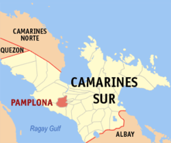
Basisdaten Bezirk: Bicol-Region Provinz: Camarines Sur Barangays: 17 Distrikt: 1. Distrikt von Camarines Sur PSGC: 051726000 Einkommensklasse: 4. Einkommensklasse Haushalte: 5421 Zensus 1. Mai 2000Einwohnerzahl: 31.895 Zensus 1. August 2007Bevölkerungsdichte: 395,6 Einwohner je km² Fläche: 80,62 km² Koordinaten: 13° 36′ N, 123° 5′ O13.592123.084Koordinaten: 13° 36′ N, 123° 5′ O Postleitzahl: 4416 Bürgermeister: Gimeno Imperial Geographische Lage auf den Philippinen 

Pamplona Pamplona ist eine philippinische Stadtgemeinde in der Provinz Camarines Sur. Nach dem Zensus vom 1. Mai 2000 hat sie 29.177 Einwohner in 5421 Haushalten.
Baranggays
Pamplona ist politisch in 17 Baranggays unterteilt.
- Batang
- Burabod
- Cagbibi
- Cagbunga
- Calawat
- Del Rosario
- Patong
- Poblacion
- Salvacion
- San Gabriel
- San Isidro
- San Rafael
- San Ramon
- San Vicente
- Veneracion (Taguilid)
- Tambo
- Tampadong
Städte und Stadtgemeinden in der Provinz Camarines SurStädte: Iriga City | Naga City
Stadtgemeinden: Baao | Balatan | Bato | Bombon | Buhi | Bula | Cabusao | Calabanga | Camaligan | Canaman | Caramoan | Del Gallego | Gainza | Garchitorena | Goa | Lagonoy | Libmanan | Lupi | Magarao | Milaor | Minalabac | Nabua | Ocampo | Pamplona | Pasacao | Pili | Presentacion | Ragay | Sagñay | San Fernando | San Jose | Sipocot | Siruma | Tigaon | Tinambac
Wikimedia Foundation.
Schlagen Sie auch in anderen Wörterbüchern nach:
Pamplona, Camarines Sur — Infobox Philippine municipality infoboxtitle = Municipality of Pamplona sealfile = locatormapfile = Ph locator camarines sur pamplona.png| caption = Map of Camarines Sur showing the location of Pamplona region = Bicol Region (Region V) province … Wikipedia
Camarines Sur (Provinz) — Lage der Provinz Camarines Sur Camarines Sur ist eine Provinz der Philippinen im Bezirk V, welcher sich auf der Insel Luzon befindet. Die Hauptstadt der Provinz ist Pili. Camarines Sur ist mit 5267 km² die größte Provinz des Bezirkes. Insgesamt… … Deutsch Wikipedia
Camarines Sur — Lage der Provinz Camarines Sur Camarines Sur ist eine Provinz der Philippinen im Bezirk V, die sich im Südosten der Insel Luzon befindet. Die Hauptstadt der Provinz ist Pili. Camarines Sur ist mit 5267 km² die größte Provinz des Bezirkes.… … Deutsch Wikipedia
Camarines Sur — 13° 40′ 00″ N 123° 19′ 59″ E / 13.6667, 123.333 … Wikipédia en Français
Naga, Camarines Sur — City of Naga Ciudad nin Naga Lungsod ng Naga Seal Nickname(s) … Wikipedia
Nabua, Camarines Sur — Nabua Municipality Seal … Wikipedia
Magarao, Camarines Sur — Magarao Municipality Map of Camarines Sur showing the location of Magarao … Wikipedia
Minalabac, Camarines Sur — Minalabac Municipality Map of Camarines Sur showing the location of Minalabac … Wikipedia
Ocampo, Camarines Sur — Ocampo Municipality Map of Camarines Sur showing the location of Ocampo … Wikipedia
Tigaon, Camarines Sur — Tigaon Municipality Map of Camarines Sur showing the location of Tigaon … Wikipedia
Pamplona (Camarines Sur)


18+
© Academic, 2000-2026
- Kontaktieren Sie uns: Unterstützung, Werbung
Wörterbücher Export, schritte mit PHP, Joomla, Drupal, WordPress, MODx.