- Milaor
-
Municipality of Milaor Lage von Milaor in der Provinz Camarines Sur 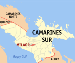
Basisdaten Bezirk: Bicol-Region Provinz: Camarines Sur Barangays: 20 Distrikt: 2. Distrikt von Camarines Sur PSGC: 051721000 Einkommensklasse: 4. Einkommensklasse Haushalte: 4013 Zensus 1. Mai 2000Einwohnerzahl: 26.452 Zensus 1. August 2007Bevölkerungsdichte: 1130 Einwohner je km² Fläche: 23,41 km² Koordinaten: 13° 36′ N, 123° 11′ O13.6123.18333333333Koordinaten: 13° 36′ N, 123° 11′ O Postleitzahl: 4413 Bürgermeister: Roger Flores Geographische Lage auf den Philippinen 

Milaor Milaor ist eine philippinische Stadtgemeinde in der Provinz Camarines Sur. Nach dem Zensus vom 1. Mai 2000 hat sie 22.635 Einwohner in 4013 Haushalten.
Baranggays
Milaor ist politisch in 20 Baranggays unterteilt.
- Alimbuyog
- Amparado (Pob)
- Balagbag
- Borongborongan
- Cabugao
- Capucnasan
- Dalipay
- Del Rosario (Pob)
- Flordeliz
- Lipot
- Mayaopayawan
- Maycatmon
- Maydaso
- San Antonio
- San Jose (Pob)
- San Miguel (Pob)
- San Roque (Pob)
- San Vicente (Pob)
- Santo Domingo (Pob)
- Tarusanan
Städte und Stadtgemeinden in der Provinz Camarines SurStädte: Iriga City | Naga City
Stadtgemeinden: Baao | Balatan | Bato | Bombon | Buhi | Bula | Cabusao | Calabanga | Camaligan | Canaman | Caramoan | Del Gallego | Gainza | Garchitorena | Goa | Lagonoy | Libmanan | Lupi | Magarao | Milaor | Minalabac | Nabua | Ocampo | Pamplona | Pasacao | Pili | Presentacion | Ragay | Sagñay | San Fernando | San Jose | Sipocot | Siruma | Tigaon | Tinambac
Wikimedia Foundation.
Schlagen Sie auch in anderen Wörterbüchern nach:
Milaor — Original name in latin Milaor Name in other language Milaor, Santo Domingo State code PH Continent/City Asia/Manila longitude 13.5961 latitude 123.1772 altitude 5 Population 8809 Date 2012 01 17 … Cities with a population over 1000 database
Milaor, Camarines Sur — Milaor Municipality Map of Camarines Sur showing the location of Milaor … Wikipedia
Metro Naga — is a metropolitan area composed of 14 municipalities centered around Naga City, Camarines Sur, Philippines. The MNDC covers most of 2nd district of the province of Camarines Sur, and part of its 1st, 3rd and 4th districts. Metro Naga … Wikipedia
Magarao, Camarines Sur — Magarao Municipality Map of Camarines Sur showing the location of Magarao … Wikipedia
Minalabac, Camarines Sur — Minalabac Municipality Map of Camarines Sur showing the location of Minalabac … Wikipedia
Ocampo, Camarines Sur — Ocampo Municipality Map of Camarines Sur showing the location of Ocampo … Wikipedia
San Fernando, Camarines Sur — Infobox Philippine municipality infoboxtitle = Municipality of San Fernando sealfile = locatormapfile = Ph locator camarines sur san fernando.png| caption = Map of Camarines Sur showing the location of San Fernando region = Bicol Region (Region… … Wikipedia
Camarines Sur (Provinz) — Lage der Provinz Camarines Sur Camarines Sur ist eine Provinz der Philippinen im Bezirk V, welcher sich auf der Insel Luzon befindet. Die Hauptstadt der Provinz ist Pili. Camarines Sur ist mit 5267 km² die größte Provinz des Bezirkes. Insgesamt… … Deutsch Wikipedia
Naga (Philippinen) — Naga City Ciudad nin Naga Lungsod ng Naga Lage von Naga in der Provinz Camarines Sur Basisdaten Bezirk: Bicol Region … Deutsch Wikipedia
PH-CAS — Lage der Provinz Camarines Sur Camarines Sur ist eine Provinz der Philippinen im Bezirk V, welcher sich auf der Insel Luzon befindet. Die Hauptstadt der Provinz ist Pili. Camarines Sur ist mit 5267 km² die größte Provinz des Bezirkes. Insgesamt… … Deutsch Wikipedia
Milaor


18+
© Academic, 2000-2026
- Kontaktieren Sie uns: Unterstützung, Werbung
Wörterbücher Export, schritte mit PHP, Joomla, Drupal, WordPress, MODx.