Planargia

Planargia
Planargia.

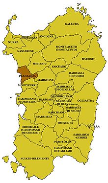
Die Planargia ist eine Hochebene auf der Westseite Sardiniens, die sich zwischen dem Tal des Temo bei dem Ort Bosa im Norden und dem bis zu 1000 m hohen Bergland des ehemaligen Vulkans Monte Ferru im Süden in der Provinz Oristano erstreckt. Landschaftlich wird sie von der Arborea im Süden, der Barbagia im Osten und dem Logudoro im Norden begrenzt. Im Westen grenzt die Planargia ans Meer.

Die hochgelegenen Hauptorte der Planargia sind Cuglieri und Santu Lussurgiu. Daneben sind S´Archittu, San Leonardo de Siete Fuentes und Tresnuraghes zu nennen. Das umgebende Gebiet bietet Wälder, Hügel- und Flusslandschaften, Strände mit feinem Sand oder hohe Klippen. Als Vegetation kommen hauptsächlich Lecci-Wälder vor. Das Massiv des Monte Ferru liegt an der Straße von Cuglieri nach Santu Lussurgiu und besteht aus Basalt und Trachyt. Die höchsten Gipfel sind der Monte Urtigu mit 1.050 m und der Monte Entu mit 1.024 m.

Von archäologischem Interesse sind die Domus de Janas von Serrugiu aus der Jungsteinzeit und die Ruinen der Stadt Cornus, bei Santa Caterina di Pittinuri. Cornus war, wie Tharros, eine punische Stadt, die im Jahre 211 v. Chr. römisch wurde. Im 4. Jahrhundert n. Chr. wurde der Ort in „Columbaris“ umbenannt und war christliches Zentrum mit der ältesten Kirche Sardiniens. Die dreischiffige Basilika mit Apsis und Taufbecken ist als Ruine zu besichtigen. An der Küste liegen auch die Genueser- oder Sarazenentürme (Cappo Nieddu, Torre del Pozzo, Torre di Foghe). Unter den Nuraghen, die am Rand der Planargia liegen, sind der Protonuraghe Seneghe bei Suni und der Großnuraghe Lugherras bei Paulilatino besonders zu beachten, aber nur schwer zu finden.

Weblinks

  • [1] (mehrseitig umfassend, Italienisch)

Wikimedia Foundation.

Игры ⚽ Нужно решить контрольную?

Schlagen Sie auch in anderen Wörterbüchern nach:

  • IT-88 — Sardinien Basisdaten Hauptstadt …   Deutsch Wikipedia

  • Sardegna — Sardinien Basisdaten Hauptstadt …   Deutsch Wikipedia

  • Province de Nuoro — Provincia di Nuoro Administration Pays  Italie Région …   Wikipédia en Français

  • Province de nuoro — Fichier:Provincia di Nuoro Stemma.png Pays  …   Wikipédia en Français

  • Giovanni Maria Angioy — (Bono, 21 October 1751 Paris, February 22, 1808) was a Sardinian politician and patriot and to this day he is considered a national hero in Sardinia.Angioy guided the Sardinian revolutionary (1794 1796) against the feudal privileges still… …   Wikipedia

  • Scano di Montiferro — Infobox CityIT img coa = official name = Scano di Montiferro name = Scano di Montiferro region = Sardinia province = Province of Oristano (OR) elevation m = 380 area total km2 = 60.5 population as of = Dec. 2004 population total = 1690 population …   Wikipedia

  • List of Italian IGT wines — A list of the Italian IGT ( Indicazione Geografica Tipica ) wines, in alphabetical order by region. Note that IGT wines are not produced in Piedmont or the Val’Aosta.Wines of the Abruzzo*Alto Tirino ( Bianco in the styles normale , Frizzante and… …   Wikipedia

  • Andrew of Arborea — Andrew or Andreotto (died 3 April 1308) was the Judge of Arborea from 1304. He was the elder of two illegitimate sons of John and Vera Cappai. He co ruled with his brother Marianus III, but he had the supremacy and the title autocrator basileus …   Wikipedia

  • Bahnstrecke Macomer–Bosa — Macomer–Bosa Streckenlänge: 48,0 km …   Deutsch Wikipedia

  • Liste der historischen Regionen auf Sardinien — Anglona Arborea Barbagia Baronia Campidano Cixerri Gallura Gerrei Goceano Iglesiente La Nurra Logudoro Mandrolisari Marghine Marmilla Meilogu Ogliastra Planargia Romangia Sarcidano Sarrabus Sulcis Trexenta Weblinks …   Deutsch Wikipedia

Share the article and excerpts

Direct link
Do a right-click on the link above
and select “Copy Link”