- Potoky
-
Potoky
Wappen Karte 
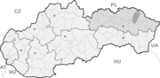

Potoky BasisdatenKraj: Prešovský kraj Okres: Stropkov Region: Horný Zemplín Fläche: 5,58 km² Einwohner: 87 (31. Dez. 2010) Bevölkerungsdichte: 15,59 Einwohner je km² Höhe: 246 m n.m. Postleitzahl: 091 01 (Postamt Stropkov) Telefonvorwahl: 0 54 Geographische Lage: 49° 15′ N, 21° 38′ O49.25777777777821.625246Koordinaten: 49° 15′ 28″ N, 21° 37′ 30″ O Kfz-Kennzeichen: SP Gemeindekennziffer: 527726 StrukturGemeindeart: Gemeinde Verwaltung (Stand: November 2010)Bürgermeister: Milan Vavrek Adresse: Obecný úrad Potoky
09101 StropkovGemeindeinformation
auf portal.gov.skStatistikinformation
auf statistics.skPotoky (bis 1927 slowakisch „Potoka“; ungarisch Pataki - bis 1902 Potoka) ist eine Gemeinde in der nordöstlichen Slowakei. Der Name bedeutet auf deutsch etwa „Bäche“.
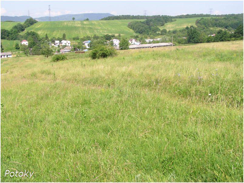
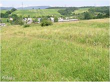 Blick auf Potoky
2001 gaben 83 von 87 Einwohnern slowakisch als Nationalität an.
Inhaltsverzeichnis
Lage
Der Ort liegt etwa 6 Kilometer nördlich von Stropkov und ebensoweit entfernt südöstlich von Svidník im Bergland Ondavská vrchovina.
Geschichte
Die Gemeinde wurde 1551 zum ersten Mal schriftlich erwähnt, 1910 hatte sie 116 - überwiegend russinische - Einwohner. Bis zum Friedensvertrag von Trianon lag der Kreis Stropkov im Komitat Semplin im Königreich Ungarn.
Sehenswürdigkeiten
- Holzkirche Sankt Paraskeva (1773)
Weblinks
 Commons: Potoky – Sammlung von Bildern, Videos und AudiodateienGemeinden im Okres Stropkov
Baňa | Breznica | Breznička | Brusnica | Bukovce | Bystrá | Bžany | Duplín | Gribov | Havaj | Chotča | Jakušovce | Kolbovce (Kolbenhau) | Korunková | Kožuchovce | Krišľovce | Kručov | Krušinec | Lomné | Makovce | Malá Poľana | Miková | Miňovce | Mrázovce | Nižná Olšava | Oľšavka | Potoky | Potôčky | Soľník | Staškovce | Stropkov (Stropko) | Šandal | Tisinec | Tokajík | Turany nad Ondavou | Varechovce | Veľkrop | Vislava | Vladiča | Vojtovce (Vogthau) | Výškovce | Vyšná Olšava | Vyšný Hrabovec
Wikimedia Foundation.
Schlagen Sie auch in anderen Wörterbüchern nach:
Potoky — (Village) Administration Pays Slovaquie … Wikipédia en Français
Potoky — is a village and municipality in Stropkov District in the Prešov Region of north eastern Slovakia.HistoryIn historical records the village was first mentioned in 1551.GeographyThe municipality lies at an altitude of 246 metres and covers an area… … Wikipedia
Kam"iani Potoky — Infobox City settlement type = Village subdivision type = Country official name = Kam iani Potoky| native name = Кам яні Потоки| subdivision name = Ukraine subdivision type1 = Oblast region type local = Raion subdivision name1 = Poltava region… … Wikipedia
Mayak Resort — (Kam”yani Potoky,Украина) Категория отеля: Адрес: Lenina Street 149, Kam”yani Potoky … Каталог отелей
List of villages in Poltava Oblast — This is a list of villages of the Poltava Oblast (province) of central Ukraine.Chornukhynskyi Raion (Чорнухинський район)* Bogodarivka * ChornukhyChutivskyi Raion (Чутівський район)* Artemivka * ChutoveDykanskyi Raion (Диканський район)* Bayrak * … Wikipedia
Krucov — Kručov Wappen Karte … Deutsch Wikipedia
Lhota u Vsetína — Lhota u Vsetína … Deutsch Wikipedia
Liste der Städte und Gemeinden in der Slowakei/M-R — Übersicht M bis R Teil 1 A bis G Teil 2 H bis Ľ Teil 3 M bis R Teil 4 S bis Ž Übersicht M N Ň O P R M Städte und Gemeinden in der Slowakei … Deutsch Wikipedia
Liste der Städte und Gemeinden in der Slowakei Teil 3 — Übersicht M bis R Teil 1 A bis G Teil 2 H bis Ľ Teil 3 M bis R Teil 4 S bis Ž Übersicht M N Ň O P R M Städte und Gemeinden in der Slowakei … Deutsch Wikipedia
Minovce — Miňovce Wappen Karte … Deutsch Wikipedia
Potoky

18+
© Academic, 2000-2025
- Kontaktieren Sie uns: Unterstützung, Werbung
Wörterbücher Export, schritte mit PHP, Joomla, Drupal, WordPress, MODx.