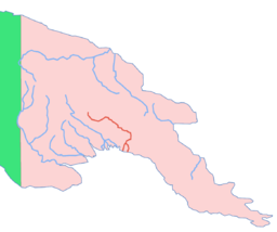
Purari

Purari
Purari
New guinea purari.PNG
DatenVorlage:Infobox Fluss/GKZ_fehlt
Lage Provinz Gulf (Papua-Neuguinea)
Flusssystem Purari
Abfluss über Purari → Pazifischer Ozean
Ursprung Zusammenfluss von Tua und Pio
6° 24′ 0″ S, 144° 15′ 0″ O-6.4144.25
Vorlage:Infobox Fluss/QUELLHÖHE_fehlt
Mündung mit 2 Armen in den Golf von Papua. Aufspaltung:
-7.5078330327152145.09197235107

7° 30′ 28″ S, 145° 5′ 31″ O-7.5078330327152145.09197235107
Vorlage:Infobox Fluss/MÜNDUNGSHÖHE_fehltVorlage:Infobox Fluss/HÖHENUNTERSCHIED_fehlt
Länge 470 kmVorlage:Infobox Fluss/NACHWEISE_fehlen
Einzugsgebiet 33.670 km²Vorlage:Infobox Fluss/NACHWEISE_fehlen

Vorlage:Infobox Fluss/ABFLUSS_fehltVorlage:Infobox Fluss/BILD_fehlt

Der Purari (englisch Purari River) ist ein Fluss, der im südlichen zentralen Hochland von Papua-Neuguinea entspringt. Er ist 470 km lang und fließt durch die Gulf-Provinz in den Golf von Papua, wo er schließlich mündet. Der Purari hat ein Einzugsgebiet von 33.670 km² und ist der drittgrößte Fluss in Papua-Neuguinea.

Nebenflüsse sind die Flüsse Kaugel, Erave, Tua und Pio.


Wikimedia Foundation.

Игры ⚽ Нужна курсовая?

Schlagen Sie auch in anderen Wörterbüchern nach:

  • Purari — may refer to: *Purari River *Purari language …   Wikipedia

  • Purari — 7° 30′ 28″ S 145° 05′ 31″ E / 7.50783, 145.092 …   Wikipédia en Français

  • Purari language — Purari Spoken in Papua New Guinea Region Purari River, Gulf Province Native speakers 7,000  (1991) Language family Trans–New Guinea …   Wikipedia

  • Purari River — Vorlage:Infobox Fluss/BILD fehltVorlage:Infobox Fluss/DGWK fehltVorlage:Infobox Fluss/QUELLHÖHE fehltVorlage:Infobox Fluss/MÜNDUNGSHÖHE fehltVorlage:Infobox Fluss/HÖHENUNTERSCHIED fehltVorlage:Infobox Fluss/ABFLUSS fehlt Purari Lage Provinz Gulf …   Deutsch Wikipedia

  • Purari River — Geobox River name = Purari map caption = Location of the Purari country = Papua New Guinea region = Gulf length = 470 length round = 0 length note = watershed = 33670 watershed round = 0 watershed note = discharge location = discharge average =… …   Wikipedia

  • Purari River — River, eastern central New Guinea. Rising in the central highlands of Papua New Guinea, it flows about 290 mi (470 km) to the Gulf of Papua of the Coral Sea. Its lower course divides into five main channels that lace through a well settled swampy …   Universalium

  • Purari — ISO 639 3 Code : iar ISO 639 2/B Code : ISO 639 2/T Code : ISO 639 1 Code : Scope : Individual Language Type : Living …   Names of Languages ISO 639-3

  • Purari, río — Río del centro este de Nueva Guinea. Nace en las tierras altas centrales de Papúa y Nueva Guinea y recorre unos 470 km (290 mi) hasta el golfo de Papúa, en el mar de Coral. Su curso inferior se divide en cinco canales principales que se… …   Enciclopedia Universal

  • Golfo de Papúa — (Gulf of Papua) Vista de satélite del golfo de Papúa Ubicación geográfica …   Wikipedia Español

  • Lenguas eleman — Distribución geográfica: Provincia del Golfo Países:   …   Wikipedia Español

Share the article and excerpts

Direct link
Do a right-click on the link above
and select “Copy Link”