- Putnam County (Georgia)
-
Verwaltung US-Bundesstaat: Georgia Verwaltungssitz: Eatonton Adresse des
Verwaltungssitzes:Putnam County Administration
108 S. Madison Avenue
Eatonton, Georgia, 31024Gründung: 10. Dezember 1807 Gebildet aus: Baldwin County Vorwahl: 001 706 Demographie Einwohner: 18.812 (2000) Bevölkerungsdichte: 21,1 Einwohner/km² Geographie Fläche gesamt: 934 km² Wasserfläche: 42 km² Karte 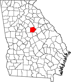
Website: www.putnamcountyga.us Das Putnam County[2] ist ein County im Bundesstaat Georgia der Vereinigten Staaten von Amerika. Der Verwaltungssitz (County Seat) ist Eatonton. Im Jahr 2000 hatte das County 18.812 Einwohner und eine Bevölkerungsdichte von 21 Einwohnern pro Quadratkilometer.
Inhaltsverzeichnis
Geografie
Das County liegt im mittleren Norden von Georgia und hat eine Fläche von 934 Quadratkilometern, wovon 42 Quadratkilometer Wasseroberfläche sind und grenzt im Uhrzeigersinn an folgende Countys: Greene County, Hancock County, Baldwin County, Jones County, Jasper County und Morgan County.
Geschichte
Putnam County wurde am 10. Dezember 1807 als 33. County in Georgia aus Teilen des Baldwin County gebildet. Benannt wurde es nach Israel Putnam, einem General aus Connecticut, der auch an der Schlacht von Bunker Hill teilnahm.
Demografische Daten
Historische Einwohnerzahlen Census Einwohner ± in % 1810 10.029 — 1820 15.475 50 % 1830 13.261 -10 % 1840 10.260 -20 % 1850 10.794 5 % 1860 10.125 -6 % 1870 10.461 3 % 1880 14.539 40 % 1890 14.842 2 % 1900 13.436 -9 % 1910 13.876 3 % 1920 15.151 9 % 1930 8367 -40 % 1940 8514 2 % 1950 7731 -9 % 1960 7798 0,9 % 1970 8394 8 % 1980 10.295 20 % 1990 14.137 40 % 2000 18.812 30 % Vor 1900[3] 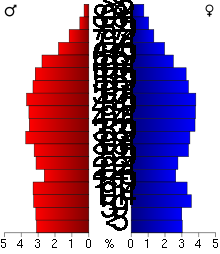 Alterspyramide für das Putnam County
Nach der Volkszählung im Jahr 2000 lebten im Putnam County 18.812 Menschen. Davon wohnten 270 Personen in Sammelunterkünften, die anderen Einwohner lebten in 7.402 Haushalten und 5.477 Familien. Die Bevölkerungsdichte betrug 21 Einwohner pro Quadratkilometer. Ethnisch betrachtet setzte sich die Bevölkerung zusammen aus 67,45 Prozent Weißen, 29,90 Prozent Afroamerikanern, 0,20 Prozent amerikanischen Ureinwohnern, 0,66 Prozent Asiaten, 0,04 Prozent Bewohnern aus dem pazifischen Inselraum und 0,82 Prozent aus anderen ethnischen Gruppen; 0,92 Prozent stammten von zwei oder mehr Ethnien ab. 2,16 Prozent der Gesamtbevölkerung waren spanischer oder lateinamerikanischer Abstammung.
Von den 7.402 Haushalten hatten 28,5 Prozent Kinder und Jugendliche unter 18 Jahren, die bei ihnen lebten. 56,8 Prozent waren verheiratete, zusammenlebende Paare, 12,8 Prozent waren allein erziehende Mütter und 26,0 Prozent waren keine Familien. 22,0 Prozent waren Singlehaushalte und in 7,8 Prozent lebten Menschen im Alter von 65 Jahren oder darüber. Die Durchschnittshaushaltsgröße betrug 2,50 und die durchschnittliche Familiengröße betrug 2,90 Personen.
23,2 Prozent der Bevölkerung waren unter 18 Jahre alt, 7,7 Prozent zwischen 18 und 24, 27,0 Prozent zwischen 25 und 44, 28,0 Prozent zwischen 45 und 64 und 14,1 Prozent waren 65 Jahre oder älter. Das Durchschnittsalter betrug 40 Jahre. Auf 100 weibliche Personen kamen statistisch 97,0 männliche Personen und auf 100 Frauen im Alter von 18 Jahren oder darüber kamen 96,4 Männer.
Das jährliche Durchschnittseinkommen eines Haushalts betrug 36.956 USD, das Durchschnittseinkommen der Familien 43.262 USD. Männer hatten ein Durchschnittseinkommen von 30.900 USD, Frauen 21.823 USD. Das Prokopfeinkommen betrug 20.161 USD. 10,5 Prozent der Familien und 14,6 Prozent der Bevölkerung lebten unterhalb der Armutsgrenze. [6]
Siehe auch
Einzelnachweise
- ↑ Auszug aus dem National Register of Historic Places. Abgerufen am 13. März 2011
- ↑ GNIS-ID: 347246. Abgerufen am 22. Februar 2011 (englisch).
- ↑ U.S. Census Bureau - Census of Population and Housing. Abgerufen am 15. März 2011
- ↑ Auszug aus Census.gov. Abgerufen am 28. Februar 2011
- ↑ Auszug aus factfinder.census.gov Abgerufen am 28. Februar 2011
- ↑ Putnam County, Georgia, Datenblatt mit den Ergebnissen der Volkszählung im Jahre 2000 bei factfinder.census.gov.
Weblinks
- georgia.gov, dort unter „Local Information | Counties“ (englisch)

Liste der Countys in Georgia
Appling | Atkinson | Bacon | Baker | Baldwin | Banks | Barrow | Bartow | Ben Hill | Berrien | Bibb | Bleckley | Brantley | Brooks | Bryan | Bulloch | Burke | Butts | Calhoun | Camden | Candler | Carroll | Catoosa | Charlton | Chatham | Chattahoochee | Chattooga | Cherokee | Clarke | Clay | Clayton | Clinch | Cobb | Coffee | Colquitt | Columbia | Cook | Coweta | Crawford | Crisp | Dade | Dawson | Decatur | DeKalb | Dodge | Dooly | Dougherty | Douglas | Early | Echols | Effingham | Elbert | Emanuel | Evans | Fannin | Fayette | Floyd | Forsyth | Franklin | Fulton | Gilmer | Glascock | Glynn | Gordon | Grady | Greene | Gwinnett | Habersham | Hall | Hancock | Haralson | Harris | Hart | Heard | Henry | Houston | Irwin | Jackson | Jasper | Jeff Davis | Jefferson | Jenkins | Johnson | Jones | Lamar | Lanier | Laurens | Lee | Liberty | Lincoln | Long | Lowndes | Lumpkin | Macon | Madison | Marion | McDuffie | McIntosh | Meriwether | Miller | Mitchell | Monroe | Montgomery | Morgan | Murray | Muscogee | Newton | Oconee | Oglethorpe | Paulding | Peach | Pickens | Pierce | Pike | Polk | Pulaski | Putnam | Quitman | Rabun | Randolph | Richmond | Rockdale | Schley | Screven | Seminole | Spalding | Stephens | Stewart | Sumter | Talbot | Taliaferro | Tattnall | Taylor | Telfair | Terrell | Thomas | Tift | Toombs | Towns | Treutlen | Troup | Turner | Twiggs | Union | Upson | Walker | Walton | Ware | Warren | Washington | Wayne | Webster | Wheeler | White | Whitfield | Wilcox | Wilkes | Wilkinson | Worth
Wikimedia Foundation.
Schlagen Sie auch in anderen Wörterbüchern nach:
Putnam County, Georgia — Infobox U.S. County county = Putnam County state = Georgia map size = 225 founded = December 10, 1807 seat = Eatonton area total sq mi =361 area land sq mi =345 area water sq mi =16 area percentage = 4.46% census yr = 2000 pop = 18812 density km2 … Wikipedia
Dennis, Putnam County, Georgia — Coordinates: 33°12′51″N 83°20′33″W / 33.21417°N 83.3425°W / 33.21417; 83.3425 Dennis is an unincorporated community in … Wikipedia
National Register of Historic Places listings in Putnam County, Georgia — This is a list of properties and districts in Putnam County, Georgia that are listed on the National Register of Historic Places (NRHP). Map of all coordinates from Google Map of all coordinates from Bing … Wikipedia
Putnam County — is the name of nine counties in the United States of America: Putnam County, Florida Putnam County, Georgia Putnam County, Illinois Putnam County, Indiana Putnam County, Missouri Putnam County, New York Putnam County, Ohio Putnam County,… … Wikipedia
Putnam County Sheriff's Office — could refer to several sheriffs departments in the United States, including:*Putnam County, Florida Sheriff s Office *Putnam County, Georgia Sheriff s Office *Putnam County, Illinois Sheriff s Office *Putnam County, Indiana Sheriff s Office… … Wikipedia
Putnam County — Es gibt in den Vereinigten Staaten neun Countys mit dem Namen Putnam County: Putnam County (Florida) Putnam County (Georgia) Putnam County (Illinois) Putnam County (Indiana) Putnam County (Missouri) Putnam County (New York) Putnam County (Ohio)… … Deutsch Wikipedia
Putnam County Courthouse — bezeichnet mehrere gleichnamige, im NRHP gelistete, Objekte: Putnam County Courthouse (Illinois), ID Nr. 75000672 Putnam County Courthouse (New York), ID Nr. 76001264 Putnam County Courthouse (Ohio), ID Nr. 74001608 Putnam County Courthouse (West … Deutsch Wikipedia
Baldwin County, Georgia — Infobox U.S. County county = Baldwin County state = Georgia seallink = map size = 225 founded = 1803 seat = Milledgeville largest city = Milledgeville area total sq mi = 268 area total km2 = 693 area land sq mi = 258 area land km2 = 669 area… … Wikipedia
Jasper County, Georgia — Infobox U.S. County county = Jasper County state = Georgia seallink = map size = 225 founded = December 10, 1807 seat = Monticello largest city = Monticello area total sq mi = 374 area total km2 = 968 area land sq mi = 370 area land km2 = 959… … Wikipedia
Hancock County, Georgia — Infobox U.S. County county = Hancock County state = Georgia seallink = map size = 225 founded = December 17, 1793 seat = Sparta largest city = Sparta area total sq mi = 479 area total km2 = 1240 area land sq mi = 473 area land km2 = 1240 area… … Wikipedia
Putnam County (Georgia)


18+
© Academic, 2000-2026
- Kontaktieren Sie uns: Unterstützung, Werbung
Wörterbücher Export, schritte mit PHP, Joomla, Drupal, WordPress, MODx.