Putumayo

Putumayo
Putumayo
Flagge
Daten
Hauptstadt Mocoa
Gouverneur Julio Byron Viveros Cháves
Fläche 24.885 km²
Einwohner (Gesamt)
 – Volkszählung 2005
 – Bevölkerungsdichte
 
310.132 
12 Einwohner/km²
Urbanisierung 83,3%
Alphabetisierungsrate 81%
Gemeindeanzahl 13
Volksbezeichnung
Wichtige Städte Orito, Puerto Asís
Karte
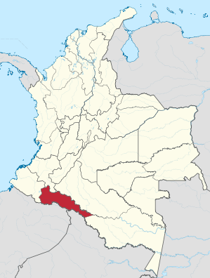
Lage von Putumayo in Kolumbien

Das Departamento de Putumayo ist eine Provinz am Südwestrand Kolumbiens. Es grenzt im Süden an die Staaten Perú und Ecuador und auf den anderen Seiten an die 4 kolumbianischen Provinzen Nariño im Westen, Cauca (nur ~50 km) und Caquetá im Norden sowie Amazonas im Osten.

Die Böden der Provinz sind prädestiniert für die Landwirtschaft. Es werden hauptsächlich Mais, Bananen, Reis, Zuckerrohr und Jamswurzeln angebaut. Auch ist die Region reich an Bodenschätzen, so wird Erdöl gefördert und es gibt Gold- und Silberbergwerke.

In Putumayo liegt der Nationalpark La Paya. Die Grenze zu Ecuador und Peru bildet der Fluss Putumayo.

Administrative Unterteilung

Das Departamento de Putumayo besteht aus 13 Gemeinden (Municipios). Die Einwohnerzahlen sind auf Grundlage der Volkszählung des DANE 2005 angegeben.

Gemeinde Einwohnerzahl 2005
Colón 5.166
Leguízamo 16.044
Mocoa 35.755
Orito 43.654
Puerto Asís 55.759
Puerto Caicedo 14.206
Puerto Guzmán 22.679
San Francisco 6.808
San Miguel 21.838
Santiago 9.209
Sibundoy 13.270
Valle del Guamuez 44.959
Villagarzón 20.785

Weblinks


Wikimedia Foundation.

Игры ⚽ Поможем сделать НИР

Schlagen Sie auch in anderen Wörterbüchern nach:

  • Putumayo — (Nianing,Сенегал) Категория отеля: Адрес: La Lagune 2, 10000 Nianing, Сенегал …   Каталог отелей

  • Putumayo [1] — Putumayo (Ica Paranna), linker Nebenfluß des Amazonenstroms, s.d. a) …   Pierer's Universal-Lexikon

  • Putumayo [2] — Putumayo (Putumayu), so v.w. Ica Paranna …   Pierer's Universal-Lexikon

  • Putumayo — Putumayo, Gold führender, 1400 km weit schiffbarer linker Nebenfluß des Amazonenstroms in Südamerika, entspringt als Iça Paranna östlich von Pasto in der Lagune Cocha im kolumb. Depart. Cáuca, 2750 m ü. M., fließt südöstlich durch Ecuador und… …   Meyers Großes Konversations-Lexikon

  • Putumayo — Putumāyo, Nebenfluß des Amazonenstroms, s.v.w. Iça …   Kleines Konversations-Lexikon

  • Putumayo — [po͞o΄to͞o mä′yō̂] river in NW South America, flowing from SW Colombia along the Colombian Peruvian border into the Amazon in NW Brazil: c. 1,000 mi (1,609 km) …   English World dictionary

  • Putumayo — Cette page d’homonymie répertorie les différents sujets et articles partageant un même nom. Putumayo est une rivière située en Amérique du Sud. Putumayo est un département de Colombie. Putumayo est un label de World music. Putumayo est un groupe… …   Wikipédia en Français

  • Putumayo — Hay varios lugares en el mundo llamados Putumayo: ● Putumayo (Departamento) en Colombia. ● Putumayo (río), en Colombia. * * * Río de América del Sur, afluente del Amazonas. Nace en los Andes colombianos, cerca de Pasto, delimita parte de la… …   Enciclopedia Universal

  • Putumayo — /pooh tooh mah yaw/, n. a river in NW South America, flowing SE from S Colombia into the Amazon in NW Brazil. 900 mi. (1450 km) long. Portuguese, Iça. * * * ▪ department, Colombia       departamento, southern Colombia. It is bounded by the… …   Universalium

  • Putumayo — Putumạyo,   1) Departamento in Kolumbien.    2) Rị́o Putumayo, linker Nebenfluss des oberen Amazonas, 1 852 km lang, entspringt am Südosthang der Ostkordillere, bildet die Grenze zwischen Kolumbien, Ecuador und Peru, mündet als Rio Içạ́ in… …   Universal-Lexikon

Share the article and excerpts

Direct link
Do a right-click on the link above
and select “Copy Link”