- Rumoi
-
Rumoi-shi
留萌市Geographische Lage in Japan Region: Hokkaidō Präfektur: Hokkaidō Koordinaten: 43° 56′ N, 141° 38′ O43.940833333333141.63666666667Koordinaten: 43° 56′ 27″ N, 141° 38′ 12″ O Basisdaten Fläche: 297,30 km² Einwohner: 24.408
(30. Juni 2011)Bevölkerungsdichte: 82 Einwohner je km² Gemeindeschlüssel: 01212-2 Symbole Baum: Akazien Blume: Azaleen Rathaus Adresse: Rumoi City Hall
1-11 Saiwai-chō
Rumoi-shi
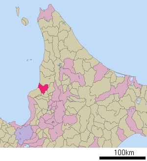
Hokkaidō 077-8601Webadresse: http://www.e-rumoi.jp Lage Rumois in der Präfektur Hokkaidō 
Rumoi (jap. 留萌市, -shi) ist eine Großstadt und Verwaltungssitz der japanischen Unterpräfektur Rumoi in der Präfektur Hokkaidō.
Inhaltsverzeichnis
Geographie
Sie liegt im Norden des Landes auf der Insel Hokkaidō knapp 100 Kilometer nördlich von Sapporo und etwa 50 Kilometer westlich von Asahikawa an der Küste des Japanischen Meeres.
Geschichte
Rumoi wurde am 1. Oktober 1947 zur Shi ernannt.
Verkehr
- Zug:
- JR Rumoi-Hauptlinie
- Straße:
- Nationalstraße 231,232,233
Städtepartnerschaften
Söhne und Töchter der Stadt
- Masaru Satō (1928–1999), Komponist
- Yatarō Watase (* 1960), Skispringer
- Yūta Watase (* 1982), Skispringer
Weblinks
-
 Commons: Rumoi – Sammlung von Bildern, Videos und Audiodateien
 - Leben in Rumoi (Englisch)
Gemeinden und Landkreise in der Präfektur HokkaidōAbashiri | Akabira | Asahikawa | Ashibetsu | Bibai | Chitose | Date | Ebetsu | Eniwa | Fukagawa | Furano | Hakodate | Hokuto | Ishikari | Iwamizawa | Kitahiroshima | Kitami | Kushiro | Mikasa | Mombetsu | Muroran | Nayoro | Nemuro | Noboribetsu | Obihiro | Otaru | Rumoi | Sapporo (Verwaltungssitz) | Shibetsu | Sunagawa | Takikawa | Tomakomai | Utashinai | Wakkanai | Yūbari
Abashiri-gun: Ōzora | Bihoro | Tsubetsu | Abuta-gun: Toyoura | Tōyako | Niseko | Makkari | Rusutsu | Kimobetsu | Kyōgoku | Kutchan | Akan-gun: Tsurui | Akkeshi-gun: Akkeshi | Hamanaka | Ashoro-gun: Ashoro | Rikubetsu | Esashi-gun: Hamatombetsu | Nakatombetsu | Esashi | Furubira-gun: Furubira | Furuu-gun: Tomari | Kamoenai | Futami-gun: Yakumo | Hidaka-gun: Shinhidaka | Hiroo-gun: Taiki | Hiroo | Hiyama-gun: Esashi | Kaminokuni | Assabu | Horoizumi-gun: Erimo | Ishikari-gun: Tōbetsu | Shinshinotsu | Isoya-gun: Rankoshi | Iwanai-gun: Kyōwa | Iwanai | Kabato-gun: Tsukigata | Urausu | Shintotsukawa | Kameda-gun: Nanae | Kamiiso-gun: Shiriuchi | Kikonai | Kamikawa-gun (Ishikari): Takasu | Higashikagura | Tōma | Pippu | Aibetsu | Kamikawa | Higashikawa | Biei | Kamikawa-gun (Teshio): Wassamu | Kembuchi | Shimokawa | Kamikawa-gun (Tokachi): Shintoku | Shimizu | Kasai-gun: Memuro | Nakasatsunai | Sarabetsu | Katō-gun: Otofuke | Shihoro | Kamishihoro | Shikaoi | Kawakami-gun: Shibecha | Teshikaga | Kayabe-gun: Shikabe | Mori | Kudō-gun: Setana | Kushiro-gun: Kushiro | Mashike-gun: Mashike | Matsumae-gun: Matsumae | Fukushima | Menashi-gun: Rausu | Mombetsu-gun: Engaru | Yūbetsu | Takinoue | Okoppe | Nishiokoppe | Ōmu | Nakagawa-gun (Teshio): Bifuka | Otoineppu | Nakagawa | Nakagawa-gun (Tokachi): Makubetsu | Ikeda | Toyokoro | Honbetsu | Niikappu-gun: Niikappu | Nishi-gun: Otobe | Notsuke-gun: Betsukai | Okushiri-gun: Okushiri | Rebun-gun: Rebun | Rishiri-gun: Rishiri | Rishirifuji | Rumoi-gun: Obira | Samani-gun: Samani | Saru-gun: Biratori | Hidaka | Setana-gun: Imakane | Shakotan-gun: Shakotan | Shari-gun: Shari | Kiyosato | Koshimizu | Shibetsu-gun: Nakashibetsu | Shibetsu | Shimamaki-gun: Shimamaki | Shiranuka-gun: Shiranuka | Shiraoi-gun: Shiraoi | Sorachi-gun: Kamifurano | Kamisunagawa | Minamifurano | Naie | Nakafurano | Namporo | Sōya-gun: Sarufutsu | Suttsu-gun: Suttsu | Kuromatsunai | Teshio-gun: Embetsu | Teshio | Horonobe | Toyotomi | Tokachi-gun: Urahoro | Tokoro-gun: Kunneppu | Oketo | Saroma | Tomamae-gun: Tomamae | Haboro | Shosambetsu | Urakawa-gun: Urakawa | Uryū-gun: Moseushi | Chippubetsu | Uryū | Hokuryū | Numata | Horokanai | Usu-gun: Sōbetsu | Yamakoshi-gun: Oshamambe | Yoichi-gun: Niki | Yoichi | Akaigawa | Yūbari-gun: Yuni | Naganuma | Kuriyama | Yūfutsu-gun: Abira | Atsuma | Mukawa | Shimukappu
Wikimedia Foundation.
Schlagen Sie auch in anderen Wörterbüchern nach:
Rumoi — ▪ Japan city, northwestern Hokkaido, Japan. It lies at the mouth of the Rumoi River, facing the Sea of Japan. The city s natural port was a fishing centre until the disappearance of herring along its coast after World War II, although cod… … Universalium
Rumoi — Original name in latin Rumoi Name in other language Rumoe, Rumoi State code JP Continent/City Asia/Tokyo longitude 43.93444 latitude 141.64278 altitude 35 Population 26454 Date 2012 01 19 … Cities with a population over 1000 database
Rumoi-shicho — Lage der Unterpräfektur Rumoi Rumoi (jap. 留萌支庁, Rumoi shichō) ist eine Unterpräfektur der Präfektur Hokkaidō. Sie hat eine Fläche von 4.019,97 km² und eine Einwohnerzahl von 61.488 (Stand: 2005). Inhaltsverzeichnis 1 … Deutsch Wikipedia
Rumoi-shichō — Lage der Unterpräfektur Rumoi Rumoi (jap. 留萌支庁, Rumoi shichō) ist eine Unterpräfektur der Präfektur Hokkaidō. Sie hat eine Fläche von 4.019,97 km² und eine Einwohnerzahl von 61.488 (Stand: 2005). Inhaltsverzeichnis 1 … Deutsch Wikipedia
Rumoi, Hokkaidō — Infobox City Japan Name= Rumoi JapaneseName= 留萌市 Map Region= Hokkaidō Prefecture= Hokkaidō (Rumoi) District= Area km2=297.44 PopDate=March 2008 Population= 26,017 Density km2=87.5 Coords= LatitudeDegrees= 43 LatitudeMinutes= 56 LatitudeSeconds=… … Wikipedia
Rumoi Subprefecture — nihongo|Rumoi|留萌支庁|Rumoi shichō is a subprefecture of Hokkaidō, Japan. As of 2004, it had a population of 63,406 and an area of 4,019.97km². Geography Cities * Rumoi (capital) Towns and villages by district *Mashike ** Mashike *Rumoi ** Obira… … Wikipedia
Rumoi District, Hokkaidō — nihongo|Rumoi|留萌郡| gun is a district located in Rumoi Subprefecture, Hokkaidō, Japan.As of 2004, the district has an estimated population of 4,337 and a density of 6.91 persons per km². The total area is 627.29 km². Town *ObiraIn July of 2004,… … Wikipedia
Rumoi Gun — Admin ASC 2 Code Orig. name Rumoi Gun Country and Admin Code JP.12.7428101 JP … World countries Adminstrative division ASC I-II
Rumoi-shi — Admin ASC 2 Code Orig. name Rumoi shi Country and Admin Code JP.12.2128378 JP … World countries Adminstrative division ASC I-II
Sous-préfecture de Rumoi — Rumoi (留萌支庁, Rumoi shichō?) est une sous préfecture d Hokkaidō au Japon. Sommaire 1 Histoire … Wikipédia en Français
- Zug:


