- Kitahiroshima
-
Kitahiroshima-shi
北広島市

Geographische Lage in Japan Region: Hokkaidō Präfektur: Hokkaidō Koordinaten: 43° 3′ N, 141° 21′ O43.05141.35Koordinaten: 43° 3′ 0″ N, 141° 21′ 0″ O Basisdaten Fläche: 118,54 km² Einwohner: 60.558
(30. Juni 2011)Bevölkerungsdichte: 511 Einwohner je km² Gemeindeschlüssel: 01234-3 Symbole Baum: Ahorne Blume: Azaleen Rathaus Adresse: Kitahiroshima City Hall
4-2-1, Chūō
Kitahiroshima-shi
Hokkaidō 061-1192Webadresse: http://www.city.kitahiroshima.hokkaido.jp Lage Kitahiroshimas in der Präfektur Hokkaidō 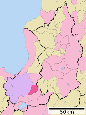
 Rathaus von Kitahiroshima
Kitahiroshima (jap. 北広島市, -shi) ist eine Stadt in der japanischen Unterpräfektur Ishikari auf der Insel Hokkaidō.
Inhaltsverzeichnis
Geographie
Kitahiroshima liegt östlich von Sapporo.
Geschichte
Kitahiroshima entstand im September 1996.
Im Jahre 2004 überschritt die Einwohnerzahl der Stadt 60.000.
Verkehr
Mehrere Autostraßen führen durch die Stadt unter anderem in nordwestliche Richtung nach Sapporo.
Städtepartnerschaften
Weblinks
-
 Commons: Kitahiroshima – Sammlung von Bildern, Videos und Audiodateien
 Gemeinden und Landkreise in der Präfektur Hokkaidō
Abashiri | Akabira | Asahikawa | Ashibetsu | Bibai | Chitose | Date | Ebetsu | Eniwa | Fukagawa | Furano | Hakodate | Hokuto | Ishikari | Iwamizawa | Kitahiroshima | Kitami | Kushiro | Mikasa | Mombetsu | Muroran | Nayoro | Nemuro | Noboribetsu | Obihiro | Otaru | Rumoi | Sapporo (Verwaltungssitz) | Shibetsu | Sunagawa | Takikawa | Tomakomai | Utashinai | Wakkanai | Yūbari
Abashiri-gun: Ōzora | Bihoro | Tsubetsu | Abuta-gun: Toyoura | Tōyako | Niseko | Makkari | Rusutsu | Kimobetsu | Kyōgoku | Kutchan | Akan-gun: Tsurui | Akkeshi-gun: Akkeshi | Hamanaka | Ashoro-gun: Ashoro | Rikubetsu | Esashi-gun: Hamatombetsu | Nakatombetsu | Esashi | Furubira-gun: Furubira | Furuu-gun: Tomari | Kamoenai | Futami-gun: Yakumo | Hidaka-gun: Shinhidaka | Hiroo-gun: Taiki | Hiroo | Hiyama-gun: Esashi | Kaminokuni | Assabu | Horoizumi-gun: Erimo | Ishikari-gun: Tōbetsu | Shinshinotsu | Isoya-gun: Rankoshi | Iwanai-gun: Kyōwa | Iwanai | Kabato-gun: Tsukigata | Urausu | Shintotsukawa | Kameda-gun: Nanae | Kamiiso-gun: Shiriuchi | Kikonai | Kamikawa-gun (Ishikari): Takasu | Higashikagura | Tōma | Pippu | Aibetsu | Kamikawa | Higashikawa | Biei | Kamikawa-gun (Teshio): Wassamu | Kembuchi | Shimokawa | Kamikawa-gun (Tokachi): Shintoku | Shimizu | Kasai-gun: Memuro | Nakasatsunai | Sarabetsu | Katō-gun: Otofuke | Shihoro | Kamishihoro | Shikaoi | Kawakami-gun: Shibecha | Teshikaga | Kayabe-gun: Shikabe | Mori | Kudō-gun: Setana | Kushiro-gun: Kushiro | Mashike-gun: Mashike | Matsumae-gun: Matsumae | Fukushima | Menashi-gun: Rausu | Mombetsu-gun: Engaru | Yūbetsu | Takinoue | Okoppe | Nishiokoppe | Ōmu | Nakagawa-gun (Teshio): Bifuka | Otoineppu | Nakagawa | Nakagawa-gun (Tokachi): Makubetsu | Ikeda | Toyokoro | Honbetsu | Niikappu-gun: Niikappu | Nishi-gun: Otobe | Notsuke-gun: Betsukai | Okushiri-gun: Okushiri | Rebun-gun: Rebun | Rishiri-gun: Rishiri | Rishirifuji | Rumoi-gun: Obira | Samani-gun: Samani | Saru-gun: Biratori | Hidaka | Setana-gun: Imakane | Shakotan-gun: Shakotan | Shari-gun: Shari | Kiyosato | Koshimizu | Shibetsu-gun: Nakashibetsu | Shibetsu | Shimamaki-gun: Shimamaki | Shiranuka-gun: Shiranuka | Shiraoi-gun: Shiraoi | Sorachi-gun: Kamifurano | Kamisunagawa | Minamifurano | Naie | Nakafurano | Namporo | Sōya-gun: Sarufutsu | Suttsu-gun: Suttsu | Kuromatsunai | Teshio-gun: Embetsu | Teshio | Horonobe | Toyotomi | Tokachi-gun: Urahoro | Tokoro-gun: Kunneppu | Oketo | Saroma | Tomamae-gun: Tomamae | Haboro | Shosambetsu | Urakawa-gun: Urakawa | Uryū-gun: Moseushi | Chippubetsu | Uryū | Hokuryū | Numata | Horokanai | Usu-gun: Sōbetsu | Yamakoshi-gun: Oshamambe | Yoichi-gun: Niki | Yoichi | Akaigawa | Yūbari-gun: Yuni | Naganuma | Kuriyama | Yūfutsu-gun: Abira | Atsuma | Mukawa | Shimukappu
Wikimedia Foundation.
Schlagen Sie auch in anderen Wörterbüchern nach:
Kitahiroshima — Original name in latin Kitahiroshima Name in other language Hiroshima, Khirosima, Kitahiroshima, Nakaosawa, bei guang dao, Хиросима State code JP Continent/City Asia/Tokyo longitude 42.97583 latitude 141.56722 altitude 19 Population 62370 Date… … Cities with a population over 1000 database
Kitahiroshima (Japan) — Hotels: Prince Hotel Kitahiroshima (Suburban) … International hotels
Kitahiroshima, Hokkaidō — Infobox City Japan Name= Kitahiroshima JapaneseName= 北広島市 Map Region= Hokkaidō Prefecture= Hokkaidō (Ishikari) District= Area km2=118.54 PopDate= June 2008 Population= 60,977 Density km2= 514 Coords= LatitudeDegrees= 42 LatitudeMinutes= 59… … Wikipedia
Kitahiroshima, Hiroshima — nihongo|Kitahiroshima|北広島町|Kitahiroshima chō is a town located in Yamagata District, Hiroshima, Japan.The town was formed on February 1, 2005 from the merger of Chiyoda, Geihoku, Ōasa, and Toyohira.As of April 1, 2004 population data, the town… … Wikipedia
Kitahiroshima Station — PAGENAME is a railway station of Chitose Line located in Hokkaidō, Japan … Wikipedia
Prince Hotel Kitahiroshima (Kitahiroshima) — Prince Hotel Kitahiroshima country: Japan, city: Kitahiroshima (Suburban) Prince Hotel Kitahiroshima Location This hotel is located at the suburban area of Sapporo. It takes 40 minute by car from Sapporo city centre or from Chitose Airport. And… … International hotels
12012 Kitahiroshima — Infobox Planet minorplanet = yes width = 25em bgcolour = #FFFFC0 apsis = name = Kitahiroshima symbol = caption = discovery = yes discovery ref = discoverer = K. Endate and K. Watanabe discovery site = Kitami discovered = November 7, 1996… … Wikipedia
Hokkaidō Expressway — 道央自動車道 Route information Length: 413.6 km (257.0 mi) … Wikipedia
Geihoku, Hiroshima — Geihoku (芸北町; cho) was a town located in Yamagata District, Hiroshima, Japan. On February 1, 2005 the town merged with three other towns from the district forming the town of Kitahiroshima.As of 2003, the town had an estimated population of 2,838 … Wikipedia
Toyohira, Hiroshima — nihongo|Toyohira|豊平町|Toyohira chō was a town located in Yamagata District, Hiroshima, Japan. On February 1, 2005 the town merged with three other towns from the district forming the town of Kitahiroshima.As of 2003, the town had an estimated… … Wikipedia
-
Kitahiroshima


18+
© Academic, 2000-2026
- Kontaktieren Sie uns: Unterstützung, Werbung
Wörterbücher Export, schritte mit PHP, Joomla, Drupal, WordPress, MODx.