- Sakaide
-
Sakaide-shi
坂出市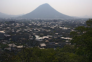
Geographische Lage in Japan 

Region: Shikoku Präfektur: Kagawa Koordinaten: 34° 19′ N, 133° 52′ O34.316469444444133.86051111111Koordinaten: 34° 18′ 59″ N, 133° 51′ 38″ O Basisdaten Fläche: 92,46 km² Einwohner: 55.138
(1. Juli 2011)Bevölkerungsdichte: 596 Einwohner je km² Gemeindeschlüssel: 37203-0 Symbole Flagge/Wappen: 
Baum: Blume: Kirschblüte, Schmuckkörbchen Rathaus Adresse: Sakaide City Hall
2-3-5, Muro-machi
Sakaide-shi
Kagawa 762-8601Webadresse: http://www.city.sakaide.lg.jp Lage Sakaides in der Präfektur Kagawa 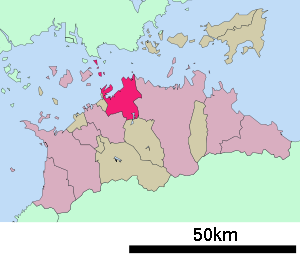
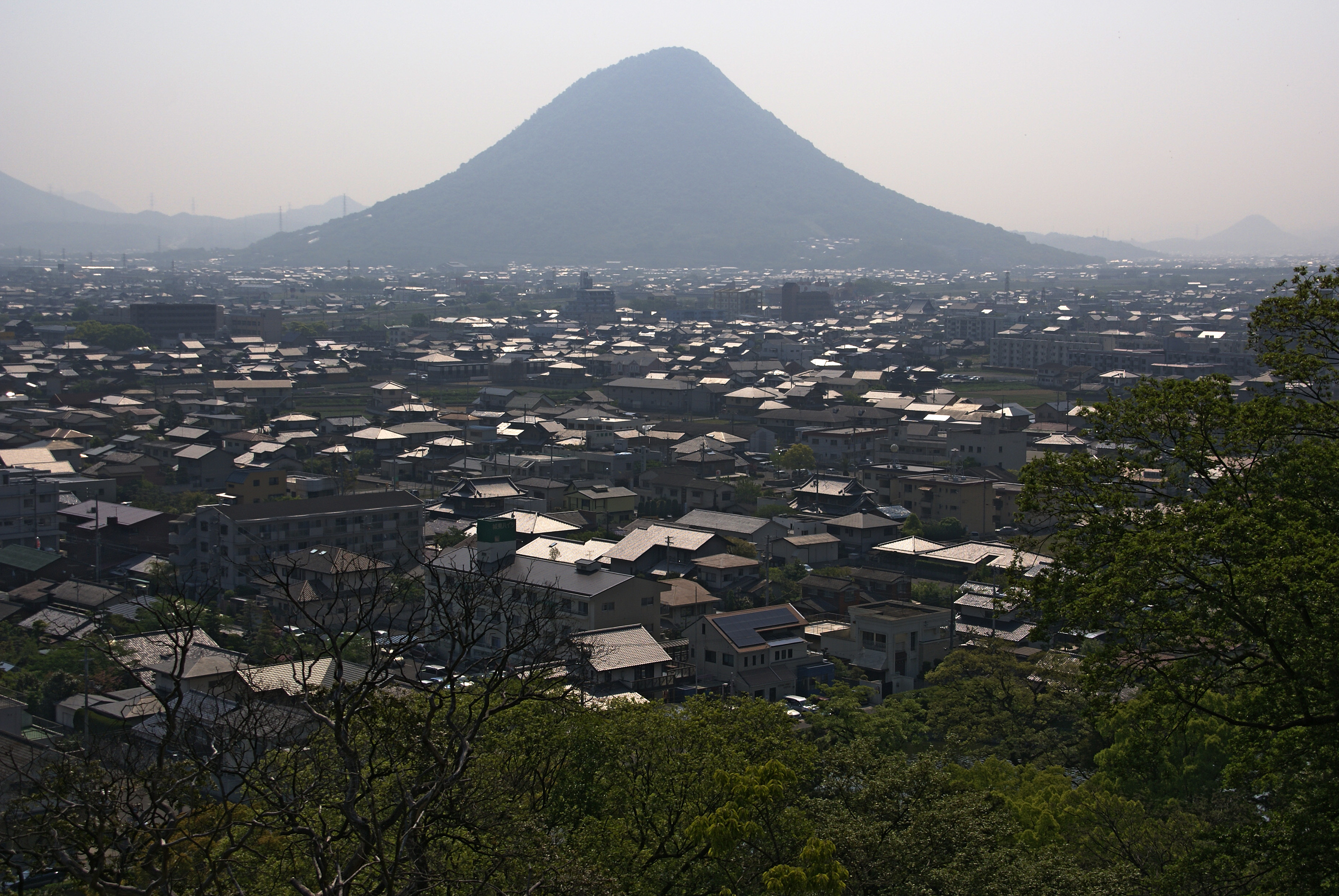
Sakaide (jap. 坂出市, -shi) ist eine Stadt in der japanischen Präfektur Kagawa.
Inhaltsverzeichnis
Geschichte
Auf dem in östlicher Richtung 7 km entfernten Berg Shiramine steht das Grab des Kaisers Sutoku (*1119-†1164)[1] Die Stadt wurde am 1. Juli 1942 gegründet. Seit 1988 führt die Seto-Ōhashi-Brücke als Verbindung von Okayama nach Shikoku über das Gebiet Sakaide.
Wirtschaft
Seit dem frühen 17. Jahrhundert ist es ein Zentrum zur Salzgewinnung. Ein Teil der Salzfelder wurde inzwischen in Industrieland umgewandelt. Neben Salz werden heute Chemikalien, Ölprodukte und Maschinen hergestellt.[1]
Verkehr
- Zug:
- Straße:
- Takamatsu-Autobahn
- Seto-Chūō-Autobahn
- Nationalstraße 11: nach Tokushima und Matsuyama
- Nationalstraße 30: nach Okayama und Takamatsu
- Nationalstraße 438
- mittelgroßer Hafen
Städtepartnerschaften
Angrenzende Städte und Gemeinden
Einzelnachweise
Weblinks
-
 Commons: Sakaide – Sammlung von Bildern, Videos und Audiodateien
 - Statistik 2008. Sakaide, 6.06, abgerufen am 13.12 (PDF, japanisch).
 Gemeinden und Landkreise in der Präfektur Kagawa
Kreisfreie Städte (shi): Higashikagawa | Kan’onji | Marugame | Mitoyo | Sakaide | Sanuki | Takamatsu (Verwaltungssitz) | Zentsūji
Ayauta-gun: Ayagawa | Utazu | Kagawa-gun: Naoshima | Kita-gun: Miki | Nakatado-gun: Kotohira | Mannō | Tadotsu | Shōzu-gun: Shōdoshima | Tonoshō
Wikimedia Foundation.
Schlagen Sie auch in anderen Wörterbüchern nach:
Sakaide — shi (坂出市) Vue sur la ville Administration Pays Japon Région Shikoku Préfecture … Wikipédia en Français
Sakaide — Original name in latin Sakaide Name in other language Sakaide, Sakaide cho, Sakaide ch Sakaidecho, Sakaidech State code JP Continent/City Asia/Tokyo longitude 34.31667 latitude 133.85 altitude 2 Population 57090 Date 2012 01 19 … Cities with a population over 1000 database
Sakaide — ▪ Japan city, Kagawa ken (prefecture), Shikoku, Japan, facing the Inland Sea. The city has been a centre of salt manufacture since the early 17th century. Part of the salt fields were reclaimed for industrial use after World War II, and… … Universalium
Sakaide, Kagawa — Infobox City Japan Name= Sakaide JapaneseName= 坂出市 Map Region= Shikoku Prefecture= Kagawa District= Area km2=92.46 PopDate=April 2008 Population=56,365 Density km2=610 Coords= LatitudeDegrees= 34 LatitudeMinutes= 19 LatitudeSeconds=… … Wikipedia
Sakaide Station — is a train station in Sakaide, Kagawa Prefecture, Japan.Lines*Shikoku Railway Company **Yosan Line (Station Y08)LayoutAdjacent stations !colspan=5|JR Shikoku ###@@@KEYEND@@@### … Wikipedia
Sakaide-shi — Admin ASC 2 Code Orig. name Sakaide shi Country and Admin Code JP.17.1853186 JP … World countries Adminstrative division ASC I-II
Hotel Route-Inn Sakaide-Kita Inter — (Sakaide,Япония) Категория отеля: 3 звездочный отель Адрес: 762 0053 Кагава … Каталог отелей
Minami-Sakaide Station — Platform Minami Sakaide Station (南酒出駅, Minami Sakaide eki?) is a … Wikipedia
Shiwaku Islands — The both meaning boiling seawater to get salt . notoc Honjima Hiroshima Ushijima Yoshima Teshima Oteshima Takamijima Shishijima Sanagishima Awashima HistorySince ancient times, the islands have been an important point for maritime… … Wikipedia
Takamatsu Expressway — The nihongo|Takamatsu Expressway|高松自動車道|Takamatsu Jidōsha dō is an expressway running in the northeastern part of the island of Shikoku and entirely in the Kagawa Prefecture. It passes through the municipalities of Higashikagawa, Sanuki,… … Wikipedia
Sakaide


18+
© Academic, 2000-2026
- Kontaktieren Sie uns: Unterstützung, Werbung
Wörterbücher Export, schritte mit PHP, Joomla, Drupal, WordPress, MODx.