- Satellite Based Augmentation System
-
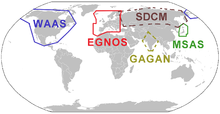 Servicegebiete der Satellite Based Augmentation Systems
Satellite Based Augmentation System (SBAS, etwa satellitenbasierte Ergänzungssysteme) sind Satellitennavigationssysteme, die vorhandene andere Satellitennavigationssysteme, insbesondere GPS oder allgemein GNSS, unterstützen. SBAS liefert zusätzliche Informationen, die von geostationären Satelliten ausgestrahlt werden und Zuverlässigkeit, Genauigkeit und Verfügbarkeit der Positionsbestimmung erhöhen.
Inhaltsverzeichnis
Systeme
Folgende SBAS-Systeme existieren, die vornehmlich für eine Anwendung im Flugnavigationsbereich gedacht sind, aber auch weit darüber hinaus genutzt werden:
- WAAS für Nordamerika (in Betrieb)
- EGNOS für Europa (in Betrieb)
- MSAS für Japan (in Betrieb)
- SDCM für Russland (im Aufbau)
- GAGAN für Indien (im Aufbau)
Diese fünf Systeme verwenden dasselbe Datenformat und ähnliche Signale, so dass SBAS-fähige Empfänger für alle vier Systeme geeignet sind. Der Nutzer erhält Informationen über:
- Integrität der GNSS-Signale,
- Korrektionen für GNSS-Satellitenuhren und -bahnen,
- Korrektionen für ionosphärisch bedingte Laufzeitverzögerungen basierend auf einem Datengitter.
Mit Hilfe dieser Informationen kann der Nutzer seine Positionsgenauigkeit von etwa 10 bis 20 m auf 1 m bis wenige Meter verbessern. Zusätzlich können die Signale, die die GPS-L1-Frequenz verwenden und GPS-C/A-Code-ähnliche Eigenschaften aufweisen, für Pseudostreckenmessungen genutzt werden, also direkt die Verfügbarkeit von GNSS verbessern.
Satelliten
SBAS-System Satellit Orbitposition PRN Nr. Bemerkung ehemalige SBAS-Satelliten (Auswahl) WAAS Inmarsat-3F4/AOR-W 142,0° W 122 zuvor auf 54,0° W, bis 2007 WAAS Inmarsat-3F3/POR 178,0° O 134 bis 2007 EGNOS Inmarsat-3F5/IOR 64,0° O 131 Testbetrieb bis 2004 GAGAN Inmarsat-4F1/IOR 64,0° O 127 Testbetrieb 2007/08 aktuell aktive SBAS-Satelliten (August 2011) WAAS Intelsat Galaxy XV 133,0° W 135 WAAS TeleSat Anik F1R 107,3° W 138 WAAS Inmarsat-4F3 98,0° W 133 EGNOS Inmarsat-3F2/AOR-E 15,5° W 120 EGNOS Artemis 21,5° O 124 EGNOS Inmarsat-4F2/IOR-W 25,0° O 126 eingeschränkter Testbetrieb GAGAN GSAT-8 55,0° O 128 Testbetrieb MSAS MTSAT-1R 140,1° O 129 nutzt z.T. auch PRN 137 MSAS MTSAT-2 145,0° O 137 nutzt z.T. auch PRN 129 zukünftige SBAS-Satelliten (Auswahl) EGNOS Astra-4B 5° O ? Start ~2011 EGNOS Astra-5B 31,5° O ? Start ~2013 SDCM Lutsch-5a 16° W ? Start ~2011, GPS/GLONASS SDCM Lutsch-5b 95° O ? Start ~2012, GPS/GLONASS SDCM Lutsch-4 167° O ? Start ~2014, GPS/GLONASS GAGAN GSAT-10 83,0° O ? Start ~2012 Weitere Dienste
Es gibt weitere, im Wesentlichen kommerzielle Dienste, die im weiteren Sinne auch als SBAS bezeichnet werden könnten:
- Starfix der Firma Fugro,
- OmniSTAR der Firma Trimble,
- StarFire der Firma John Deere,
- verschiedene Dienste der Firma Veripos.
Auch diese Dienste nutzen geostationäre Satelliten, um Ergänzungsinformationen auszusenden. Sie verwenden aber andere Signale und Datenformate, so dass diese Dienste nicht frei zugänglich sind und auch keine zusätzlichen Pseudostreckenmessungen durchgeführt werden können. Dafür sind die erzielbaren Genauigkeiten der Positionsbestimmung z.T. deutlich höher (Dezimeter-Bereich).
Einzelnachweise
Globale Systeme Historisch:
 Transit ·
  Parus/Zikada In Betrieb: GPS
  GLONASS · Im Aufbau:
  Compass ·
  Galileo
Regionale Systeme oder regionale Ergänzungssysteme Im Aufbau:
 QZSS · In Planung:
  IRNSS
IRNSSUnterstützende satellitenbasierte Systeme (SBAS) In Betrieb:
WAAS · MSAS · EGNOS Im Aufbau: GAGAN · SDCMSiehe auch Liste der Navigationssatelliten

Wikimedia Foundation.