Sisseton (South Dakota)

Sisseton (South Dakota)
Sisseton
Welcometosisseton.JPG
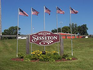
Lage von Sisseton im Roberts County
Roberts County South Dakota Incorporated and Unincorporated areas Sisseton Highlighted.svg
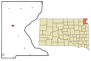
Basisdaten
Staat: Vereinigte Staaten
Bundesstaat: South Dakota
County:

Roberts County

Koordinaten: 45° 40′ N, 97° 3′ W45.663333333333-97.049166666667373Koordinaten: 45° 40′ N, 97° 3′ W
Zeitzone: Central Standard Time (UTC−6)
Einwohner: 2470 (Stand: 2010)
Bevölkerungsdichte: 602,4 Einwohner je km²
Fläche: 4,1 km² (ca. 2 mi²)
davon 4,1 km² (ca. 2 mi²) Land
Höhe: 373 m
Postleitzahl: 57262
Vorwahl: +1 605
FIPS: 46-59260
GNIS-ID: 1258093
Webpräsenz: www.sisseton.com

Sisseton ist eine Stadt im Roberts County im US-Bundesstaat South Dakota mit 2470 Einwohnern auf einer Fläche von 4.1 km² (Stand: 2010). Sisseton ist County Seat und liegt in der Lake Traverse Indian Reservation.

Demographische Daten

Das durchschnittliche Einkommen eines Haushalts liegt bei 26.698 USD, das durchschnittliche Einkommen einer Familie bei 33.977 USD. Männer haben ein durchschnittliches Einkommen von 27.393 USD gegenüber den Frauen mit durchschnittlich 20.586 USD. Das Pro-Kopf-Einkommen liegt bei 14.019 USD. 18,4 % der Einwohner und 14,9 % der Familien leben unterhalb der Armutsgrenze. 29,3 % der Einwohner sind unter 18 Jahre alt und auf 100 Frauen ab 18 Jahre und darüber kommen statistisch 86,2 Männer. Das Durchschnittsalter beträgt 36 Jahre. (Stand: 2000).

Söhne und Töchter von Sisseton


Wikimedia Foundation.

Игры ⚽ Нужно сделать НИР?

Schlagen Sie auch in anderen Wörterbüchern nach:

  • Sisseton, South Dakota — Infobox Settlement official name = Sisseton, South Dakota other name = native name = nickname = settlement type = City motto = imagesize = 250px image caption = flag size = image seal size = image shield = shield size = image blank emblem = blank …   Wikipedia

  • South Dakota Highway 127 — Infobox road state=SD type=SD route=127 length mi=37.3 established=1980 direction a=North starting terminus= ND 127 direction b=South ending terminus= cities=Rosholt, New Effington, SissetonSouth Dakota Highway 127 is a highway that runs from… …   Wikipedia

  • South Dakota District (LCMS) — The South Dakota District is one of the 35 districts of the Lutheran Church Missouri Synod (LCMS), and comprises the state of South Dakota; one in the state is in the North Dakota District. The South Dakota District includes approximately 114… …   Wikipedia

  • South Dakota locations by per capita income — South Dakota is the forty fourth richest state in the United States of America, with a per capita income of $17,562 (2000).# Cottonwood town, South Dakota $79,000 # Naples town, South Dakota $78,450 # Camp Crook town, South Dakota $30,178 #… …   Wikipedia

  • South Dakota — This article is about the U.S. state of South Dakota. For other uses, see South Dakota (disambiguation). State of South Dakota …   Wikipedia

  • South Dakota Highway Patrol — The South Dakota Highway Patrol is the State Police agency for South Dakota, which has jurisdiction everywhere in the state except for Native American reservations. It was created to protect the lives, property and constitutional rights of people …   Wikipedia

  • South Dakota Highway 10 — Infobox road state=SD marker highway name=Highway 10 length mi=193 established=1927 decommissioned= direction a=West terminus a=Jct|state=SD|SD|1804 in Pollock direction b=East terminus b=Jct|state=MN|TH|28 at Minnesota state line… …   Wikipedia

  • List of cities in South Dakota — Cities in South Dakota larger than 2,000 in population (according to the July 1, 2006 U.S. Census Bureau population estimates):# Sioux Falls 142,396 # Rapid City 62,715 # Aberdeen 24,071 # Watertown 20,526 # Brookings 18,802 # Mitchell 14,857 #… …   Wikipedia

  • Ortley, South Dakota — For other uses, see Ortley (disambiguation). Ortley, South Dakota   Town   …   Wikipedia

  • Corona, South Dakota —   Town   Location …   Wikipedia

Share the article and excerpts

Direct link
Do a right-click on the link above
and select “Copy Link”