- Thompson River (British Columbia)
-
Thompson River 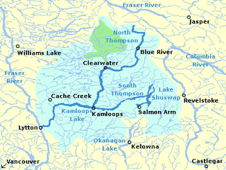
Einzugsgebiet des Thompson River
Daten Lage British Columbia (Kanada) Flusssystem Fraser River Abfluss über Fraser River → Straße von Georgia → Pazifik Quelle Zusammenfluss von North und South Thompson River bei Kamloops
50° 40′ 52″ N, 120° 20′ 23″ O50.681232229496120.339775085451113Quellhöhe 1.113 m Ursprung nahe Lytton in den Fraser River 50.23554-121.583204472Koordinaten: 50° 14′ 8″ N, 121° 35′ 0″ W
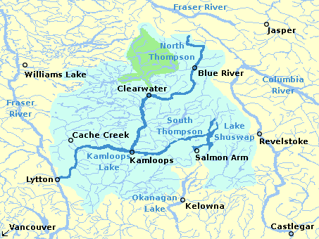
50° 14′ 8″ N, 121° 35′ 0″ W50.23554-121.583204472Mündungshöhe 472 m Höhenunterschied 641 m Länge 489 km[1] Einzugsgebiet 55.400 km²[1] Abflussmenge[1] MQ: 750 m³/s Durchflossene Seen Kamloops Lake Mittelstädte Kamloops Der Thompson River ist ein bedeutender Zufluss des Fraser River im Süden der kanadischen Provinz British Columbia. Benannt ist er nach dem Entdecker David Thompson, der als erster den Columbia River auf seiner ganzen Länge erforschte. Der Oberlauf besteht aus zwei Hauptflüssen, dem South Thompson River und dem North Thompson River. Zusammen mit seinem Quellfluss North Thompson River erreicht er eine Länge von 489 km.
Der South Thompson River (332 km Länge von der Quelle des Nebenflusses Shuswap River gemessen, 17.800 km² Einzugsgebiet)[1] beginnt am Austritt des Shuswap Lake und fließt in südwestlicher Richtung durch ein breites Tal nach Kamloops, wo er sich mit dem North Thompson River vereinigt. Der Provinz-Highway Nr. 1, der Trans-Canada Highway und die Hauptstrecke der Canadian Pacific Railway verlaufen entlang des Flusses. Der Shuswap Lake wird gespeist durch den Shuswap River im Süden, den Seymour River im Nordosten und den Adams River im Norden.
Der North Thompson River (338 km Länge, 20.700 km² Einzugsgebiet, 425 m³/s mittlerer Abfluss)[1] entspringt in den Bergen westlich des Ortes Valemount und fließt in südlicher Richtung nach Kamloops und in den South Thompson. Entlang des Flusses verlaufen der Provinz-Highway Nr. 5 und die Eisenbahnstrecke der Canadian National Railway. Das Tal des North Thompson bildet den Hauptzugang vom Süden der Provinz zum Yellowhead Pass, dem tiefstgelegenen Passübergang über die Rocky Mountains.
Gleich westlich von Kamloops liegt der Kamloops Lake. Bei Savona tritt der Fluss aus dem rund 30 Kilometer langen See aus. Zwischen den Orten Ashcroft und Lytton fließt der Thompson River durch einen Canyon. In der Nähe von Lytton mündet der Fluss in den Fraser River.
Einzelnachweise

Wikimedia Foundation.