- Utrok
-
Utirik NASA-Bild von Utirik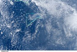
Gewässer Pazifischer Ozean Archipel Anzahl der Inseln 10 Hauptinsel Utrok Landfläche 2,43 km² Lagunenfläche 55,73 km² Einwohner 409 (2002) Geographische Lage 11° 15′ N, 169° 48′ O11.253888888889169.8Koordinaten: 11° 15′ N, 169° 48′ O 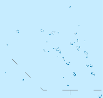
 Karte der Marshallinseln, im Osten Utirik
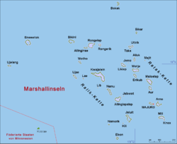
Utirik bzw. Utrok oder Utrik ist ein Atoll der Ratak-Kette der Marshallinseln. Das Atoll hat eine Landfläche von 2,43 km² bei einer Lagunenfläche von 55,73 km². Die Lagune des Atolls hat einen schiffbaren Zugang zum Meer. Die sechs größten Inseln sind: Utirik, Aon, Bikrak, Pike, Allok, Nalap.
1954 wurden alle 154 Bewohner des Eilands nach dem Bravo-Test der Operation Castle evakuiert, um einer möglichen Kontamination durch radioaktiven Niederschlag bei nachfolgenden Tests zu vorzubeugen.
Auf dem Atoll existiert ein Flugfeld, IATA-Code: UTK.
Weblinks

Ratak-Kette: Ailuk | Arno | Aur | Bikar | Bokak | Erikub | Jemo | Knox | Likiep | Majuro | Maloelap | Mejit | Mili | Toke | Utirik | Wotje
Ralik-Kette: Ailinginae | Ailinglapalap | Bikini | Ebon | Eniwetok | Jabwot | Jaluit | Kwajalein | Kili | Lae | Lib | Namorik | Namu | Rongdrik | Rongelap | Ujae | Ujelang | Wotho


Wikimedia Foundation.