- Malabe
-
Suco Malabe 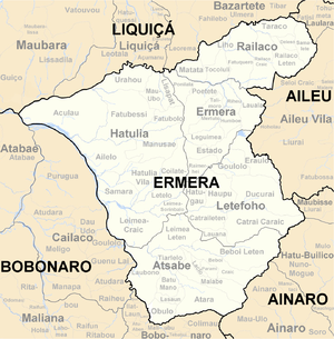
Daten Fläche 16,20 km²[1] Einwohnerzahl 1.439 (2010)[2] Chefe de Suco Luís Napolean
(Wahl 2009)Orte Position[3] Höhe Acubuli 8° 57′ S, 125° 25′ O-8.945125.41251858 1.858 m Batumigi 8° 55′ S, 125° 23′ O-8.9155555555556125.388055555561350 1.350 m Bobaleta 8° 56′ S, 125° 23′ O-8.925125.388055555561371 1.371 m Genutete 8° 56′ S, 125° 24′ O-8.9347222222222125.393611111111386 1.386 m Ilat Kora 8° 56′ S, 125° 23′ O-8.9255555555556125.389444444441371 1.371 m Lukowai 8° 56′ S, 125° 23′ O-8.9263888888889125.383055555561239 1.239 m Malabe 8° 56′ S, 125° 24′ O-8.9408333333333125.39251394 1.394 m 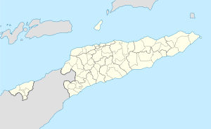

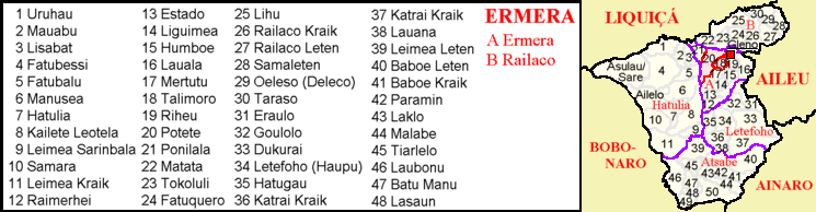
Malabe Malabe (ehemals Atadame, Atu Dame, Acu Dame) ist ein osttimoresischer Ort, Aldeia und Suco im Subdistrikt Atsabe (Distrikt Ermera).
Inhaltsverzeichnis
Der Ort
Der Ort Malabe liegt im Westen des Sucos, auf einer Meereshöhe von 1.394 m. An ihr führt die Überlandstraße von Ermera nach Maliana und Bobonaro vorbei. Hier befindet sich eine Grundschule und eine Prä-Sekundärschule.[4]
Der Suco
In Malabe leben 1.439 Einwohner (2010,[2] 2004: 1.776[5]). Der Suco liegt im Osten des Subdistrikts Atsabe und hat eine Fläche von 16,20 km².[1] Nördlich liegen die Sucos Baboi Craic, Parami und Laclo, westlich der Suco Tiarlelo und südlich der Suco Atara. Im Osten grenzt Malabe an den Subdistrikt Ainaro (Distrikt Ainaro) mit seinen Sucos Ainaro und Mau-Ulo. Die Nordwestspitze des Sucos reicht bis an den Fluss Magapu. Über den Marobo ist er mit dem Lóis verbunden, dem größten Flusssystems des Landes.[6] Nördlich der Überlandstraße liegt das Dorf Genutete und ganz im Nordteil des Sucos die Orte Ilat Kora (Ilatkora, Ilat Cora), Ratkora (Batkora), Bobaleta (Boboleta), Lukowai, Baru und Batumigi. Im Zentrum des Sucos befindet sich das Dorf Acubuli, der Südwesten ist kaum besiedelt.[6] In Acubuli befindet sich die zweite Grundschule des Sucos.[4] Seit 2009 verfügt der Suco über eine Klinik.[7]
Im Suco befinden sich die vier Aldeias Batumigi, Bobaleta, Ilat Kora und Malabe.[8]
Geschichte
Siehe auch: Geschichte OsttimorsIn Malabe wurden vier Zivilisten 1975 von den indonesischen Invasoren hingerichtet.[9]
Politik
Bei den Wahlen von 2004/2005 wurde Placido Soares zum Chefe de Suco gewählt.[10] Bei den Wahlen 2009 gewann Luís Napolean.[11]
Einzelnachweise
- ↑ a b Direcção Nacional de Estatística: Population Distribution by Administrative Areas Volume 2 English (Census 2010)
- ↑ a b Direcção Nacional de Estatística: Suco Report Volume 4 (englisch)
- ↑ Fallingrain.com: Directory of Cities, Towns, and Regions in East Timor
- ↑ a b UNMIT: Timor-Leste District Atlas version02, August 2008
- ↑ Direcção Nacional de Estatística Census 2004
- ↑ a b Timor-Leste GIS-Portal
- ↑ USaid, 17. Juli 2009, First-Ever Health Clinic Opens in Malabe
- ↑ Jornal da Républica mit dem Diploma Ministerial n.° 199/09 (Portugiesisch)
- ↑ „Part 7.4: Arbitrary, Detention, Torture and Ill treatment“ aus dem „Chega!“-Report der CAVR (englisch)
- ↑ Secretariado Técnico de Administração Eleitoral STAE: Eleições para Liderança Comunitária 2004/2005 - Resultados
- ↑ Secretariado Técnico de Administração Eleitoral STAE: Eleições para Liderança Comunitária 2009 - Resultados
Schlagen Sie auch in anderen Wörterbüchern nach:
Malabe — මලබේ மழபே Nickname(s): IT King City Motto: The Cyber City of SriLanka … Wikipedia
Pannipitiya — Infobox City | official name = Pannipitiya | pushpin timezone = Sri Lanka Standard Time Zone | utc offset = +5:30 | timezone DST = | utc offset DST = +6 latd = 6 latm = 51 lats = 0 latNS = N longd = 79 longm = 57 longs = 0 longEW = EPannipitiya… … Wikipedia
Sri Lanka Institute of Information Technology — Infobox University name =Sri Lanka Institute of Information Technology native name =SLIIT established =1999 type =Public autonomous endowment = staff =250 faculty =150 president =Prof S. Karunaratne provost = principal = rector = chancellor =… … Wikipedia
Department of Electronic and Computer Engineering, SLIIT — Department of Electronic and Computer Engineering Established 2006 Type Academic department Department Head Dr. Malitha Wijesundara Admin. staff 17 Students 450 … Wikipedia
Sucos of East Timor — Map of districts, subdistricts and sucos of East Timor East Timor … Wikipedia
Department of Computer Systems & Networking, SLIIT — Infobox University name = Department of Computer Systems Networking established = 2006 type = Academic department head label = Department Head head = Dr. Malitha Wijesundara students = 450 city = Malabe country = Sri Lanka website =… … Wikipedia
Atsabe — Subdistrikt Atsabe … Deutsch Wikipedia
List of bus routes in Colombo — A Double decker bus at Godagama A Topological map of bu … Wikipedia
List of schools in Zimbabwe — This is a partial list of schools in Zimbabwe. Many schools were given politically motivated new names in 2002. These are shown in brackets after the old name. Schools are listed alphabetically by province and then by town/city:Bulawayo*Bulawayo… … Wikipedia
List of schools in Sri Lanka — There two main types of schools in Sri Lanka, these are governmental and non governmental schools, most of these schools provide primary and secondary education.Governmental Schools are categorized into two main types, these are National Schools… … Wikipedia
Malabe

18+
© Academic, 2000-2026
- Kontaktieren Sie uns: Unterstützung, Werbung
Wörterbücher Export, schritte mit PHP, Joomla, Drupal, WordPress, MODx.