Auchenblae

Auchenblae
Auchenblae
Koordinaten 56° 54′ N, 2° 27′ W56.899444444444-2.45Koordinaten: 56° 54′ N, 2° 27′ W
Auchenblae (Schottland)
Auchenblae
Auchenblae
Verwaltung
Post town LAURENCEKIRK
Postleitzahlen­abschnitt AB30
Vorwahl 01561
Landesteil Scotland
Unitary authority Aberdeenshire
Britisches Parlament West Aberdeenshire and Kincardine
Schottisches Parlament Angus North and Mearns

Auchenblae, auch Auchinblae, (gälisch: Achadh nam Blàth[1]) ist eine schottische Ortschaft in der Unitary Authority Aberdeenshire. Sie liegt in der Region Kincardine and Mearns in der traditionellen Grafschaft Kincardineshire etwa acht Kilometer nördlich von Laurencekirk und 15 km südwestlich von Stonehaven.

Angeblich begrub der Heilige Ternan die Gebeine des Heiligen Palladius in Auchenblae. Am Südende der Ortschaft befindet sich heute eine Kapelle, die St. Palladius geweiht ist. An der Kirche von Auchenblae ist ein Piktischer Symbolstein aufgestellt, der zu den ältesten der Region gehört.[2]

Zwischen 1895 und 1930 befand sich in der Ortschaft eine Whiskybrennerei namens Auchenblae oder Auchinblae. Teile der Gebäude sind erhalten.[3]

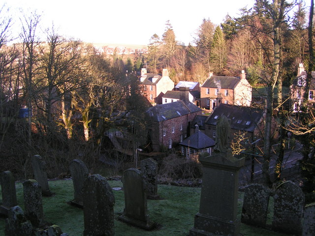
Auchenblae von der Kirche aus gesehen.

Verkehr

Die A90, die Dundee mit Fraserburgh verbindet, verläuft etwa vier Kilometer östlich der Ortschaft. Eine Eisenbahnverbindung besteht nicht.

Einzelnachweise

  1. Verzeichnis gälischer Ausdrücke
  2. Eintrag im Gazetteer for Scotland
  3. Eintrag zur Auchenblae-Brennerei auf lostdistillery.com

Wikimedia Foundation.

Игры ⚽ Нужна курсовая?

Schlagen Sie auch in anderen Wörterbüchern nach:

  • Auchenblae — infobox UK place country = Scotland static static image caption= latitude= 56.89 longitude= 02.46 official name =Auchenblae population = shire district= shire county= Aberdeenshire region= constituency westminster= post town= postcode district =… …   Wikipedia

  • Fordoun — Fourdoun is a village in Aberdeenshire, Scotland. Fothirdun (possibly the lower place ), as it was historically known, was an important area in the Howe of the Mearns. Fordoun and Auchenblae, together with their immediate districts form the… …   Wikipedia

  • Monboddo House — as restored in the year 2006 Monboddo House (56°53′N 2°25′W …   Wikipedia

  • John Christie (footballer born 1929) — Infobox Football biography playername = John Christie fullname = John Alexander Christie height = height|ft=5|in=10 dateofbirth = birth date and age|1929|9|26|df=y cityofbirth = Fraserburgh countryofbirth = Scotland currentclub = clubnumber =… …   Wikipedia

  • Tewel — Infobox UK place official name = Tewel gaelic name = scots name = country = Scotland population = os grid reference = NO828854 latitude = 56.9578 longitude = 2.2805 post town = STONEHAVEN postcode area = AB postcode district = AB39 dial code =… …   Wikipedia

  • David Lyall — For the Scottish writer using the pen name David Lyall, see Annie Shepherd Swan. David Lyall (1817–1895) MD, RN, FLS, was a Scottish botanist who explored Antarctica, New Zealand, the Arctic and North America and was a lifelong friend of Sir… …   Wikipedia

  • Stonehaven — Coordinates: 56°58′N 2°13′W / 56.96°N 2.21°W / 56.96; 2.21 …   Wikipedia

  • Palladius — (fl. 408 431; probably died ca 457/461) was the first Bishop of the Christians of Ireland, preceding Saint Patrick.It is believed that he is the same Palladius that is earlier described as the deacon of Saint Germain of Auxerre. If this is the… …   Wikipedia

  • Dunnottar Castle — For the ship, see RMS Dunottar Castle. Dunnottar Castle Dùn Fhoithear Near Stonehaven, Aberdeenshire, Scotland …   Wikipedia

  • Drum Castle — Location of Drum Castle within Aberdeenshire. Drum Castle is a castle near Drumoak …   Wikipedia

Share the article and excerpts

Direct link
Do a right-click on the link above
and select “Copy Link”