- Ba-Phalaborwa
-
Ba-Phalaborwa
Ba-Phalaborwa Local MunicipalitySymbole Wappen Wahlspruch
„Progressus“
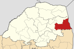
FortgeschrittenBasisdaten Staat Südafrika Provinz Limpopo Distrikt Mopani Sitz Phalaborwa Fläche 3.004 km² Einwohner 127.307 (24. Oktober 2007) Dichte 42,4 Einwohner pro km² Schlüssel LIM334 ISO 3166-2 ZA-LP Webauftritt www.ba-phalaborwa. gov.za (englisch) Politik Bürgermeister Anna Sono -23.983330.5333Koordinaten: 23° 59′ S, 30° 32′ OBa-Phalaborwa ist eine Gemeinde im Distrikt Mopani, Provinz Limpopo in Südafrika mit Sitz in Phalaborwa. Dzumisani Gloria Valoyi ist die Bürgermeisterin.[1]
Der Gemeindename kommt vom Wort pala bora („besser als der Süden“) in der Sprache der Sotho, die von Süden hierher zogen.[2]
Ortschaften in der Gemeinde sind: Ba Phalaborwa Ba Nakome, Ba-Phalaborwa, Bashai-Ditlou, Corundum, Die Eiland, Ga-Mashishimale, La Cotte, Letaba Ranch, Leydsdorp, Lulekani, Majeje, Mulati, Namakgale, Nondweni, Phalaborwa und Selati River.
Weblinks
- Offizieller Internetauftritt (englisch)
Einzelnachweise
- ↑ Contact information: Ba-Phalaborwa Local Municipality (englisch). Abgerufen am 5. Februar 2010.
- ↑ Gemeindenamen Südafrikas
Gemeinden in MopaniBa-Phalaborwa | Greater Giyani | Greater Letaba | Greater Tzaneen | Maruleng
Wikimedia Foundation.
Schlagen Sie auch in anderen Wörterbüchern nach:
Phalaborwa — Phalaborwa … Deutsch Wikipedia
Phalaborwa — is a town (131,000 inhabitants) situated in the Mopani district, halfway up along the length of the Kruger National Park in the Limpopo province in South Africa. The Lowveld, also known as Valley of the Olifants, has the highest winter… … Wikipedia
Phalaborwa — 23° 55′ 56″ S 31° 08′ 27″ E / 23.932139, 31.140769 … Wikipédia en Français
Phalaborwa — ▪ South Africa also spelled Ba Phalaborwa , Palabora mining town, Limpopo province, South Africa, located east of the Drakensberg mountains and north of the Olifants River near Kruger National Park. It is built on top of an old black… … Universalium
Phalaborwa — Original name in latin Phalaborwa Name in other language PHW, Palabora, Palaborva, Phalaborwa, Палаборва State code ZA Continent/City Africa/Johannesburg longitude 23.94299 latitude 31.14107 altitude 435 Population 109468 Date 2012 07 12 … Cities with a population over 1000 database
Phalaborwa — Phalabọrwa, Stadt (seit 1957) in der Nord Provinz, Republik Südafrika, 540 m über dem Meeresspiegel, im Lowveld, etwa 11 000 Einwohner. Bei Phalaborwa werden seit 1952 Phosphate, seit 1964 auch Kupfererze, Vermiculit, Magnetit u. a. im … Universal-Lexikon
Mine de Phalaborwa — Phalaborwa 23° 55′ 56″ S 31° 08′ 27″ E / 23.932139, 31.140769 … Wikipédia en Français
PHW — Phalaborwa, South Africa internationale Flughafen Kennung … Acronyms
PHW — Phalaborwa, South Africa internationale Fughafen Kennung … Acronyms von A bis Z
Impisi Lodge Safari and Golf Guesthouse — (Phalaborwa,Южно Африканская Республика) Категория отеля: Адрес … Каталог отелей