- Bojadła
-
Bojadła (Boyadel) 


Bojadła (Boyadel) Basisdaten Staat: Polen Woiwodschaft: Lebus Landkreis: Zielona Góra Geographische Lage: 51° 57′ N, 15° 49′ O51.9515.816666666667Koordinaten: 51° 57′ 0″ N, 15° 49′ 0″ O Einwohner: 1200 (2006)
Postleitzahl: 66-130 Telefonvorwahl: (+48) 68 Kfz-Kennzeichen: FZI Wirtschaft und Verkehr Nächster int. Flughafen: Flughafen Posen Gemeinde Gemeindeart: Landgemeinde Fläche: 102,6 km² Einwohner: 3376
(31. Dez. 2010) [1]Bevölkerungsdichte: 33 Einw./km² Gemeindenummer (GUS): 0809022 Verwaltung (Stand: 2007) Gemeindevorsteher: Jacek Biliński Adresse: ul. Sulechowska 35
66-130 BojadłaWebpräsenz: www.bojadla.pl Bojadła (deutsch: Boyadel) ist eine Gemeinde im Powiat Zielonogórski in der Woiwodschaft Lebus, Polen.
Inhaltsverzeichnis
Geschichte
+
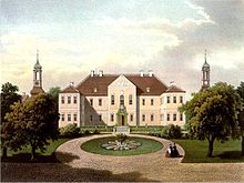 Schloss Boyadel um 1860, Sammlung Alexander Duncker
Das Gemeindegebiet zählte bis 1945 zum Landkreis Grünberg.
Gemeinde (Gmina Bojadła)
Zur Landgemeinde Bojadła gehören folgende Ortschaften (deutsche Namen bis 1945) mit Schulzenamt (sołectwo):
- Bełcze (Rauschmühle)
- Bojadła (Boyadel)
- Kartno (Kern)
- Klenica (Kleinitz)
- Młynkowo
- Przewóz
- Pyrnik (Pirnig)
- Siadcza
- Susłów
Weitere Ortschaften der Gemeinde ohne Schulzenamt sind:
Karczemka, Kliniczki, Pólko, Sosnówka und Wirówek.
Einzelnachweise
- ↑ Population. Size and Structure by Territorial Division. As of December 31, 2010. Główny Urząd Statystyczny (GUS), abgerufen am 10. Juli 2011.
Weblinks
 Commons: Bojadła – Sammlung von Bildern, Videos und Audiodateien
- Material zu Schloss Boyadel in der Sammlung Duncker der Zentral- und Landesbibliothek Berlin (PDF; 215 kB)
Städte und Gemeinden im Powiat ZielonogórskiBabimost (Bomst) – Stadt | Bojadła (Boyadel) | Czerwieńsk (Rothenburg an der Oder) – Stadt | Kargowa (Unruhstadt) – Stadt | Nowogród Bobrzański (Naumburg am Bober) – Stadt | Sulechów (Züllichau) – Stadt | Świdnica (Schweinitz) | Trzebiechów (Trebschen) | Zabór (Saabor) | Zielona Góra (Grünberg-Land)
Wikimedia Foundation.
Schlagen Sie auch in anderen Wörterbüchern nach:
Bojadla — Original name in latin Bojada Name in other language Bojadla, Bojada, Boyadel State code PL Continent/City Europe/Warsaw longitude 51.95321 latitude 15.81036 altitude 58 Population 1200 Date 2010 10 16 … Cities with a population over 1000 database
Gmina Bojadła — Infobox Settlement name = Gmina Bojadła other name = Bojadła Commune settlement type = Gmina total type = Total image shield = POL gmina Bojadła COA.svg subdivision type = Country subdivision name = POL subdivision type1 = Voivodeship subdivision … Wikipedia
Młynkowo, Lubusz Voivodeship — For other places with the same name, see Młynkowo. Młynkowo Village … Wikipedia
Гмина Боядла — Gmina Bojadła Герб Страна: Польша Повят: Зелёногурский повят Глава: Яцек Билиньский Площадь: 102,55 км² … Википедия
Sosnówka, Lubusz Voivodeship — Sosnówka is a village in Poland located in Lubusz Voivodeship, in Zielona Góra County, in Bojadła Commune [ [http://bip.bojadla.pl/content.php?cms id=3||menu=p1 Sosnówka on map on official site of Bojadła Commune] ] . coord|51|58|N|15|51|E|region … Wikipedia
Гмины Любушского воеводства — … Википедия
Боядла (гмина) — Гмина Боядла Gmina Bojadła Герб … Википедия
Zielona Góra County — Infobox Settlement name = Zielona Góra County native name = Powiat zielonogórski settlement type = image shield = POL powiat zielonogórski COA.svg map caption = Location within the voivodeship subdivision type = Country subdivision name = POL… … Wikipedia
Gmina Kolsko — Infobox Settlement name = Gmina Kolsko other name = Kolsko Commune settlement type = Gmina total type = Total image shield = subdivision type = Country subdivision name = POL subdivision type1 = Voivodeship subdivision name1 = Lubusz subdivision… … Wikipedia
Gmina Nowa Sól — Nowa Sól Commune Gmina … Wikipedia
Bojadła


18+
© Academic, 2000-2025
- Kontaktieren Sie uns: Unterstützung, Werbung
Wörterbücher Export, schritte mit PHP, Joomla, Drupal, WordPress, MODx.