Coyote Acres

Coyote Acres
Coyote Acres
Coyote Acres (Texas)
Coyote Acres
Coyote Acres
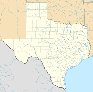
Lage in Texas
Basisdaten
Staat: Vereinigte Staaten
Bundesstaat: Texas
County:

Jim Wells

Koordinaten: 27° 43′ N, 98° 8′ W27.7225-98.13416666666770Koordinaten: 27° 43′ N, 98° 8′ W
Zeitzone: Central Standard Time (UTC−6)
Einwohner: 389 (Stand: 2000)
Bevölkerungsdichte: 29,5 Einwohner je km²
Fläche: 13,2 km² (ca. 5 mi²)
davon 13,2 km² (ca. 5 mi²) Land
Höhe: 70 m
FIPS: 48-17426
GNIS-ID: 1852695

Coyote Acres ist ein Census-designated place (CDP) im Jim Wells County, Texas in den Vereinigten Staaten. Die Bevölkerungszahl betrug 389[1] (Stand: 2000).

Inhaltsverzeichnis

Geografie

Dem United States Census Bureau zufolge hat der CDP eine Gesamtfläche von 13.2 km².

Unterricht

Coyote Acres wird von Alice Independent School District bedient.

Demografie

Laut der Volkszählung aus dem Jahre 2000 gab es im CDP 389 Einwohner, 109 Haushalte und 92 Familien, die im CDP ansässig waren. Die Bevölkerungsdichte betrug 29,4 Einwohner pro Quadratkilometer. Der Median des Einkommen je Haushalt lag bei US$ 19.250, der Median des Einkommens einer Familie bei US$ 14.083. Das Pro-Kopf-Einkommen liegt bei 6709 US-Dollar. 57,3 % der Einwohner und 45,8 % der Familien leben unterhalb der Armutsgrenze. Das Durchschnittsalter beträgt 26 Jahre.

Von den 109 Haushalten hatten 45,9 % Kinder unter 18 Jahre, die im Haushalt lebten.

Einzelnachweise

  1. American Factfinder. In: United States Census Bureau. Abgerufen am 28. Januar 2010.

Weblinks


Wikimedia Foundation.

Игры ⚽ Поможем написать реферат

Schlagen Sie auch in anderen Wörterbüchern nach:

  • Coyote Acres — Coyote Acres, TX U.S. Census Designated Place in Texas Population (2000): 389 Housing Units (2000): 113 Land area (2000): 5.108173 sq. miles (13.230106 sq. km) Water area (2000): 0.000000 sq. miles (0.000000 sq. km) Total area (2000): 5.108173 sq …   StarDict's U.S. Gazetteer Places

  • Coyote Acres, TX — U.S. Census Designated Place in Texas Population (2000): 389 Housing Units (2000): 113 Land area (2000): 5.108173 sq. miles (13.230106 sq. km) Water area (2000): 0.000000 sq. miles (0.000000 sq. km) Total area (2000): 5.108173 sq. miles… …   StarDict's U.S. Gazetteer Places

  • Coyote Acres, Texas —   CDP   Coordinates …   Wikipedia

  • Coyote — bezeichnet eine in Nordamerika verbreitete Wildhundart, siehe Kojote den Künstlernamen des amerikanischen Schauspielers Robert Peter Cohon, siehe Peter Coyote einen mexikanischen Fußballspieler, siehe Alberto Coyote Orte in den Vereinigten… …   Deutsch Wikipedia

  • Coyote Point Park — Coyote Point Type Parkland, woodland, museum zoo Location San Mateo County, California, USA …   Wikipedia

  • Coyote Lake (Santa Clara County, California) — Coyote Lake Location Santa Clara County, California[1] Coordinates …   Wikipedia

  • Coyote Springs, Nevada — Coyote Springs development in 2006 Coyote Springs, Nevada, is a master planned community being developed in Lincoln County and Clark County, Nevada, by developer and attorney lobbyist Harvey Whittemore and Pardee Homes. Contents …   Wikipedia

  • Coyote Creek State Park — Coordinates: 35°55′12″N 105°9′50″W / 35.92°N 105.16389°W / 35.92; 105.16389 …   Wikipedia

  • Coyote Valley — This article is about the proposed development in San Jose. For the reservation in Mendocino County, see Coyote Valley Reservation. Coyote Valley from Santa Teresa County Park, April 1, 2006 Coyote Valley (see also Coyote, California) is a large… …   Wikipedia

  • Coyote Hills Regional Park — This article is about the park in Alameda County, California. For other uses, see Coyote Hills. View of Coyote Hills from the south, across a salt marsh …   Wikipedia

Share the article and excerpts

Direct link
Do a right-click on the link above
and select “Copy Link”