- Faraulep
-
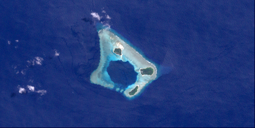
Faraulep NASA-Bild des Atolls
Gewässer Pazifischer Ozean Archipel Karolinen Geographische Lage 8° 36′ N, 144° 31′ O8.5930555555556144.51055555556Koordinaten: 8° 36′ N, 144° 31′ O 

Anzahl der Inseln 3 Hauptinsel Nigaruyaru Länge 4,1 km Breite 3,0 km Landfläche 42,2 ha Lagunenfläche 2,336 km² Gesamtfläche 7 km² Einwohner 221 (2000) Yap (Staat) mit Faraulep im Osten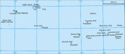
Das Atoll Faraulep oder Faraulap liegt im Osten des Bundesstaats Yap der Föderierten Staaten von Mikronesien und gehört damit zur Inselgruppe der Karolinen im Pazifischen Ozean.
Geographie
Faraulep liegt 116 km südwestlich der Insel Gaferut und 695 ostsüdöstlich der Hauptinsel von Yap. Das Atoll weist einen annähernd quadratischen Grundriss auf, mit Seitenlängen von 3 bis 4 km, und einer Gesamtfläche von 7 km²[1]. Der breite Riffranz umschließt eine kleine, tiefe Lagune, die nur im Südwesten eine Öffnung aufweist. Das Atoll weist drei Inseln auf, mit einer Gesamtfläche von gut 40 Hektar:[2]
- Fuasubukoru (8° 36′ 56″ N, 144° 32′ 2″ O8.6155555555556144.53388888889), bewohnt, 10,2 ha
- Nigaruyaru (8° 36′ 23″ N, 144° 32′ 4″ O8.6063888888889144.53444444444), bewohnt, 20,2 ha
- Eate (8° 35′ 14″ N, 144° 33′ 0″ O8.5872222222222144.55), unbewohnt, 11,7 ha
Die Bevölkerung betrug 221 zur Volkszählung 2000 [3]. Sie verteilt sich auf die beiden Dörfer Nigaruyaru und Fuasubukoru auf den gleichnamigen Inseln.
Verwaltung
Faraulep bildet eine Gemeinde (municipality) des Staates Yap, zu der auch die Insel Gaferut gehört. Die Gemeinde gehört zum vierten Wahlbezirk des Bundesstaates Yap, einem der insgesamt fünf Wahlbezirke.[4][5].
Einzelnachweise
- ↑ Oceandots
- ↑ Otis W. Freeman, Geography of the Pacific, Wiley 1953
- ↑ 2000 census of Yap
- ↑ http://www.pacificworlds.com/yap/home/location.cfm
- ↑ Yap State Code, Title 7, Elections, §111 Election districts
 Inseln und Atolle von Yap (Föderierte Staaten von Mikronesien)
Hauptgruppe: Yap-Inseln: Yap | Gagil-Tomil | Maap | Rumung
Atolle: Ngulu | Ulithi | Turtle Islands | Zohhoiiyoru Bank | Sorol | Eauripik | Woleai | Faraulep | Ifalik | Lamolior | Elato | West Fayu | Olimarao | Lamotrek
Wikimedia Foundation.
Schlagen Sie auch in anderen Wörterbüchern nach:
Faraulep — Original name in latin Faraulep Name in other language State code FM Continent/City Pacific/Chuuk longitude 8.588 latitude 144.508 altitude 9999 Population 0 Date 2011 01 12 … Cities with a population over 1000 database
Faraulep Municipality — Admin ASC 2 Code Orig. name Faraulep Municipality Country and Admin Code FM.04.FP FM … World countries Adminstrative division ASC I-II
Ifalik — Vorlage:Infobox Insel/Wartung/Höhe fehlt Ifalik ISS Foto des Atolls Gewässer Pazifischer Ozean Archipel … Deutsch Wikipedia
Фараулеп — англ. Faraulep … Википедия
Yap — Infobox Settlement name =Yap official name = other name = native name = nickname = settlement type =Island total type = motto = imagesize = image caption = flag size = image seal size = image shield = shield size = image blank emblem = blank… … Wikipedia
Woleai — Vorlage:Infobox Insel/Wartung/Höhe fehlt Woleai Lagekarte des Bundesstaates Yap Gewässer Pazifischer Ozean Archipel … Deutsch Wikipedia
Woléaï — L’île de Woléaï (ou Woleai, ou localement Wottegai) (7°22′N 143°54′E / 7.367, 143.9) est l’île principale de l’atoll de Woléaï (également appelé localement Wolea, Uleai … Wikipédia en Français
Gaferut — Vorlage:Infobox Insel/Wartung/Bild fehlt Gaferut Gewässer Pazifischer Ozean Inselgruppe Karolinen Geographische Lage … Deutsch Wikipedia
Grayling (butterfly) — Taxobox name = Grayling image width = 204px image caption = Female regnum = Animalia phylum = Arthropoda classis = Insecta ordo = Lepidoptera unranked familia = Rhopalocera superfamilia = Papilionoidea familia = Nymphalidae subfamilia = Satyrinae … Wikipedia
List of administrative divisions of Micronesia — Below is a list of administrative divisions of Micronesia. Cities of Micronesia *Colonia, Yap *Kolonia *Lelu *Palikir National capital *Tol *Weno Federated States of Micronesia Subdivisions Chuuk, State of * Dublon (Tonowas) * Eot * Ettal * Fala… … Wikipedia
Faraulep

18+
© Academic, 2000-2026
- Kontaktieren Sie uns: Unterstützung, Werbung
Wörterbücher Export, schritte mit PHP, Joomla, Drupal, WordPress, MODx.