- Fylakio
-
Fylakio
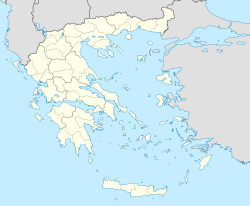
ΦυλάκιοBasisdaten Staat: Griechenland Region: Ostmakedonien und Thrakien Regionalbezirk: Evros Gemeinde: Orestiada Geographische Koordinaten: 41° 35′ N, 26° 19′ O41.58333333333326.316666666667Koordinaten: 41° 35′ N, 26° 19′ O Einwohner: 473 (2001[1]) LAU-1-Code-Nr.: 71040301 Fylakio (griechisch Φυλάκιο (n. sg.)) ist ein griechisches Dorf in der Region Ostmakedonien und Thrakien. Es liegt dreißig Kilometer von der türkisch-griechischen Grenze entfernt.[2]
Flüchtlingslager
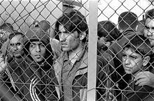
In Südosten des Dorfes liegt ein bewachtes Lager, in dem die Flüchtlinge vorübergehend festgehalten werden, die versucht haben, illegal die türkisch-griechische Grenze zu überqueren. Für die Europäische Agentur für die operative Zusammenarbeit an den Außengrenzen (Frontex) dient das Lager vor allem zur Feststellung der Nationalität der Immigranten. Laut Human Rights Watch (HRW) ist das Lager überfüllt und es herrschen sehr schlechte hygienische Bedingungen. Auch sollen Kinder und Jugendliche keine gesonderten Unterkünfte und keine soziale Betreuung bekommen. Anfang Dezember 2010, als HRW das Lager besuchte, sollen 450 Insassen, darunter 120 Minderjährige, dort gelebt haben.[2]
Mitte September 2011 besuchten mehrere Bundestagsabgeordnete, darunter Stephan Mayer und Rüdiger Veit, das Flüchtlingslager in Fylakio und in Tychero. Die Abgeordneten bezeichneten die Umstände als „menschenunwürdig“ und „indiskutabel“. Nach ihren Angaben wurde der zuständige, griechische Minister Christos Papoutsis von ihnen mit den Missständen konfrontiert.[3]
Weblinks
Einzelnachweise
- ↑ Nationaler Statistischer Dienst Griechenlands (ΕΣΥΕ): Volkszählung 2001. In: Volkszählung 2001. 2001, S. 80, abgerufen am 13. Dezember 2010 (PDF, 1.009 kb, griechisch).
- ↑ a b Jürgen Gottschlich: Europas größtes Loch. In: die tageszeitung. 10. Dezember 2010, abgerufen am 10. Dezember 2010 (deutsch).
- ↑ Roland Preuß: Menschenunwürdige Zustände. In: Süddeutsche Zeitung. 18. September 2011, abgerufen am 19. September 2011 (englisch).
Kategorien:- Ort in Ostmakedonien und Thrakien
- Orestiada
Wikimedia Foundation.


