Flinders Municipality

Flinders Municipality
Flinders
LGATasmania Flinders.png
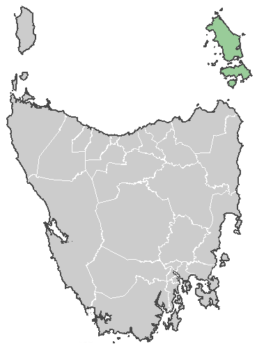
Lage der Flinders Municipality in Tasmanien
Gliederung
Staat: Australien Australien
Bundesstaat: Flag Australia tasmania.png Tasmanien
Verwaltungssitz: Whitemark
Daten und Zahlen
Fläche: 1.333 km²
Einwohner: 864 (2006) [1]
Bevölkerungsdichte: 0,6 Einwohner je km²
-40.116666666667148.01666666667

Die Flinders Municipality ist ein lokales Verwaltungsgebiet (LGA) im australischen Bundesstaat Tasmanien. Das Gebiet ist 1.333 km² groß und hat etwa 860 Einwohner.

Die LGA besteht aus vier Inselgruppen in der Bass-Straße im Nordosten der tasmanischen Hauptinsel. Bewohnt sind davon nur die drei großen Inseln Flinders Island, Cape Barren Island und Clarke Island der Furneaux-Gruppe, unbewohnt sind die drei nordöstlich davon gelegenen kleineren Gruppen Kent, Hogan und Curtis. 14 Ortschaften und Gemeinden liegen auf den Inseln: Blue Rocks, Cape Barren Island, Emita, Killiecrankie, Lackrana, Lady Barron, Leeka, Loccota, Lughrata, Memana, Palana, Ranga, Whitemark und Wingaroo[2]. Der Sitz des Councils befindet sich in Whitemark auf Flinders Island, wo etwa 600 Einwohner leben.[3]

Verwaltung

Der Flinders Council hat sieben Mitglieder. Der Mayor (Bürgermeister), sein Deputy (Stellvertreter) und fünf Councillor werden direkt von den Bewohnern der LGA gewählt. Flinders ist nicht in Bezirke untergliedert.

Quellen

  1. Australian Bureau of Statistics (25. Oktober 2007): Flinders (LGA) (Englisch). 2006 Census QuickStats. Abgerufen am 6. April 2010.
  2. Localities by Council, Local Government Association of Tasmania
  3. Australian Bureau of Statistics (25. Oktober 2007): Whitemark (State Suburb) (Englisch). 2006 Census QuickStats. Abgerufen am 23. März 2010.

Weblinks


Wikimedia Foundation.

Игры ⚽ Поможем написать курсовую

Schlagen Sie auch in anderen Wörterbüchern nach:

  • Flinders Island — Infobox Islands name = Flinders Island image caption = Furneaux Group from space, April 1993 locator native name = native name link = location = Tasmania coordinates= coord|40|00|S|148|07|E|type:isle region:AU TAS area = 1,333 km² (515 sq mi)… …   Wikipedia

  • Flinders — There are many places with the word Flinders in their name. Most of these are in south east Australia and are named for explorer Matthew Flinders.* Flinders, Victoria, suburb of Melbourne, Victoria * Flinders, New South Wales, suburb of… …   Wikipedia

  • Local Government Areas of Tasmania — Local Government Areas of Tasmania, Australia This article also includes lists of towns, suburbs and localities of Tasmania.Hobart area councilsBrighton Council*Hobart suburbs: **Bridgewater Gagebrook Old Beach *Brighton *Pontville *Tea TreeCity… …   Wikipedia

  • King Island (Tasmania) — Infobox Islands name = King Island image caption = King Island from space, April 1993 (South is at top) locator native name = native name link = location = Tasmania coordinates= 39°52 S 143°59 E area = 1 098 km² (424 sq mi) highest mount = Mount… …   Wikipedia

  • Melbourne — This article is about the Australian metropolis. The name may also refer to the Melbourne City Centre (also known as the Central Business District or CBD ) or the City of Melbourne (the Local Government Area within which the Melbourne City Centre …   Wikipedia

  • Melbourne City Centre — This article is about the locality within the postcodes 3000, 3004 and 3006 of Melbourne in Victoria, Australia, officially known as Melbourne . For the Greater Melbourne metropolitan area, see Melbourne. For the local government area that… …   Wikipedia

  • City of Rockingham — This article is about a local government authority. For the suburb, see Rockingham, Western Australia. City of Rockingham Western Australia The City of Rockingham within …   Wikipedia

  • Trams in Melbourne — Melbourne tramway network D1.3508 in Bank of Melbourne wrap livery outside Melbourne Town Hall, Swanston Street, 2011 …   Wikipedia

  • City of Adelaide — For other uses, see City of Adelaide (disambiguation). City of Adelaide South Australia …   Wikipedia

  • Wollongong, New South Wales — Infobox Australian Place type = city name = Wollongong state = nsw imagesize = 270 caption = pop = 263,535 pop footnotes = poprank = 9th density = 385.3 density footnotes = est = postcode = 2500 coordinates =… …   Wikipedia

Share the article and excerpts

Direct link
Do a right-click on the link above
and select “Copy Link”