Golden (British Columbia)

Golden (British Columbia)
Golden
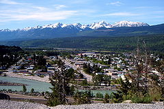
Ansicht von Golden
Ansicht von Golden
Lage in British Columbia
Golden (British Columbia)
Golden
Golden
Staat: Kanada
Provinz: British Columbia
Regionaldistrikt: Columbia-Shuswap
Koordinaten: 51° 18′ N, 116° 58′ W51.29614-116.96305800Koordinaten: 51° 18′ N, 116° 58′ W
Höhe: 800 m
Fläche: 11,02 km²
Einwohner: 3811 (Stand: 2006)
Bevölkerungsdichte: 345,8 Einw./km²
Zeitzone: Pacific Time (UTC−8)
Postleitzahl: V0A

Golden ist ein Ort im südöstlichen British Columbia, Kanada, etwa 262 Straßenkilometer von Calgary, Alberta im Osten und 713 Straßenkilometer von Vancouver im Westen entfernt. Golden liegt im Columbia Valley. Der Ort entstand am Zusammenfluss von Columbia River und Kicking Horse River und ist von drei Bergketten umgeben. In der Nähe liegen fünf Nationalparks, Yoho-Nationalpark, Banff-Nationalpark, Jasper-Nationalpark, Glacier-Nationalpark und Kootenay-Nationalpark.

Durch Golden führt der Highway 1 (Trans-Canada Highway). Hier befindet sich der Endpunkt des Highway 95, der den Ort mit den Vereinigten Staaten und dem restlichen Gebiet der East-Kootenay-Region und der Stadt Cranbrook verbindet.

Ein großer Teil der örtlichen Geschichte ist verbunden mit der Canadian Pacific Railway und der Holzfäller-Industrie. Heutzutage stützt sich der Ort immer noch auf diese beiden Wirtschaftszweige, die Entwicklung des Kicking Horse Resort zusammen mit anderen Betrieben der Freizeitindustrie haben jedoch eine wirtschaftliche Diversifikation im Ort zugelassen. Der Hausberg (Mount 7), südöstlich des Ortes gelegen, ist ein beliebtes Ziel für Paraglider, Hanggleiter und Mountainbiker. Golden beheimatet eine Zweigstelle des College of the Rockies.

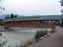
Die Kicking-Horse-Fußgängerbrücke ist die längste freigespannte Timberframe-Brücke in Kanada, entstanden als ein Gemeindeprojekt der Timber Framers Guild und Freiwilligen aus dem Ort Golden, die von durchreisenden Zimmerleuten und Timberframern aus Kanada, den Vereinigten Staaten und Europa unterstützt wurden.

Weblinks

Kicking Horse Pedestrian Bridge

Wikimedia Foundation.

Игры ⚽ Поможем написать курсовую

Schlagen Sie auch in anderen Wörterbüchern nach:

  • Golden, British Columbia — Infobox Settlement official name = Town of Golden other name = native name = nickname = settlement type = Town motto = imagesize = image caption = Golden, British Columbia flag size = image seal size = image shield = shield size = city logo =… …   Wikipedia

  • British Columbia — Colombie Britannique (French) …   Wikipedia

  • Golden Village (Richmond, British Columbia) — Golden Village is a commercial district of Richmond, British Columbia, Canada best known for its high concentration of Asian themed shopping malls. It is the home to the second largest Asian community in North America [… …   Wikipedia

  • Invermere, British Columbia — Infobox Settlement official name = Pagename other name = native name = nickname = settlement type = Municipality motto = imagesize = image caption = Invermere, British Columbia, with Mount Nelson in the distance flag size = image seal size =… …   Wikipedia

  • British Columbia Highway 5 — Highway 5 Southern Yellowhead Highway Coquihalla Highway Route information Length: 524 km (326 mi) …   Wikipedia

  • British Columbia Highway 1 — Infobox road state=BC type=Hwy route=1 alternate name=Trans Canada Highway length km=1039 length round=0 length ref=Fact|date=August 2007 established=1961Fact|date=August 2007 direction a=West direction b=East terminus a=Victoria junction=… …   Wikipedia

  • British Columbia Railway — Logo von BC Rail Streckennetz Die British Columbia Railway (BC RAIL) w …   Deutsch Wikipedia

  • British Columbia Highway 7B — Highway 7B Mary Hill Bypass Highway 7B highlighted in red …   Wikipedia

  • British Columbia, flag of — ▪ Flag History       Canadian provincial flag that is horizontally divided, bearing an elongated Union Jack (United Kingdom, flag of the) emblem in its upper half and wavy stripes of white and blue and a stylized portion of the sun in its lower… …   Universalium

  • British Columbia Highway 95 — Infobox road province=BC type=Hwy route=95 maint= length km= length round= length ref= established= direction a= starting terminus= junction= direction b= ending terminus= previous type=Hwy previous route=93 next type=Hwy next route=97Highway 95… …   Wikipedia

Share the article and excerpts

Direct link
Do a right-click on the link above
and select “Copy Link”