- Haupu
-
Suco Haupu 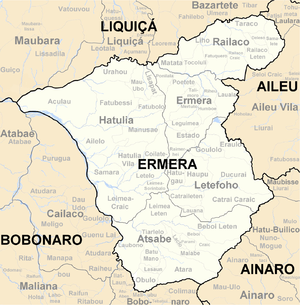
Daten Fläche 16,31 km²[1] Einwohnerzahl 4.488 (2010)[2] Chefe de Suco Eugebio Alcino Maia
(Wahl 2009)Orte Position[3] Höhe Assi 8° 51′ S, 125° 25′ O-8.8563888888889125.408888888891180 1.180 m Duhoho 8° 50′ S, 125° 25′ O-8.8308333333333125.421495 1.495 m Hauleo 8° 49′ S, 125° 24′ O-8.8222222222222125.407222222221412 1.412 m Haupu 8° 49′ S, 125° 26′ O-8.8219444444444125.425277777781522 1.522 m Kairia 8° 51′ S, 125° 26′ O-8.8419444444444125.430555555561510 1.510 m Letefoho 8° 50′ S, 125° 26′ O-8.8344444444444125.426388888891533 1.533 m Lutulala 8° 50′ S, 125° 26′ O-8.8324066325125.42579591278[4] ? Manukati Leten 8° 51′ S, 125° 25′ O-8.8441666666667125.416388888891417 1.417 m Riamori 8° 51′ S, 125° 26′ O-8.8577777777778125.434722222221361 1.361 m Riatoni 8° 51′ S, 125° 26′ O-8.8516666666667125.438888888891442 1.442 m 

Haupu Haupu (Haupau, ehemals Letefoho) ist ein osttimoresischer Ort, Aldeia und Suco im Subdistrikt Letefoho (Distrikt Ermera). Im Suco liegt Letefoho, die Hauptstadt des Subdistrikts.
Inhaltsverzeichnis
Der Ort
Haupu liegt 1.522 m über dem Meeresspiegel, an der Nordgrenze des Sucos zum Nachbarn Goulolo.[5]
Der Suco
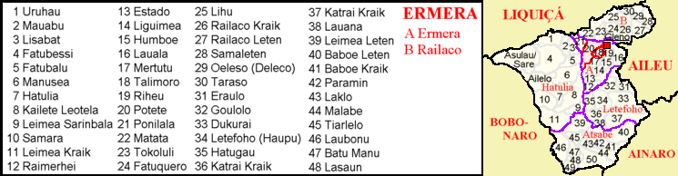
In Haupu leben 4.488 Einwohner (2010,[2] 2004: 3.881[6]). Der Suco Haupu liegt im Nordwesten des Subdistrikts Letefoho und hat eine Fläche von 16,31 km².[1] Im Nordosten liegt der Suco Goulolo, im Osten Ducurai, im Südosten Catrai Caraic, im Süden Catraileten und im Westen Hatugau. Nordwestlich grenzt Haupu an den Subdistrikt Ermera mit seinem Suco Raimerhei. Die Südgrenze bildet der Fluss Pusulu, die Nordwestgrenze der Fluss Hatoe.[5]
Durch den Osten des Sucos führt die Überlandstraße von der Distriktshauptstadt Gleno nach Atsabe und weiter nach Süden. An der Straße liegt auch Letefoho, der größte Ort des Sucos und Hauptstadt des Subdistrikts. Weitere Orte an der Straße im Suco sind Kairia, Riatoni und Riamori. Im Norden liegen die Orte Haupu, Lutulala, Duhoho und Hauleo (Haulio, Hauho). Im Südwesten befinden sich die Dörfer Assi und Manukati Leten (Manucatilaten). In Letefoho gibt es eine Vorschule, eine Grundschule, eine präsekundäre Schule (Escola Pre-Secondaria No. 705 Letefoho Villa/Haupu),[7] ein Hubschrauberlandeplatz und ein kommunales Gesundheitszentrum. Weitere Grundschulen gibt es in Assi, Riamori, Duhoho und Haupu.[8]
In Haupu liegen die zwölf Aldeias Assi, Beturema, Duhoho, Hatuhou, Hauleo, Haupu, Kairia, Lutlala, Manukati Leten, Raepusa, Riamori und Riatoni.[9]
Geschichte
Siehe auch: Geschichte Osttimors1903 scheiterte ein Aufstand des Reichs von Letefohos gegen die portugiesischen Kolonialherren.[10]
Der Ort Letefoho musste nach der Gewalt um das Unabhängigkeitsreferendum von 1999 größtenteils wieder neu aufgebaut werden.[11]
Politik
Bei den Wahlen von 2004/2005 wurde Mariano Soares zum Chefe de Suco gewählt.[12] Bei den Wahlen 2009 gewann Eugebio Alcino Maia.[13]
Einzelnachweise
- ↑ a b Direcção Nacional de Estatística: Population Distribution by Administrative Areas Volume 2 English (Census 2010)
- ↑ a b Direcção Nacional de Estatística: Suco Report Volume 4 (englisch)
- ↑ Fallingrain.com: Directory of Cities, Towns, and Regions in East Timor
- ↑ Get Coordinate - Wiki Koordinaten ermitteln
- ↑ a b Timor-Leste GIS-Portal
- ↑ Direcção Nacional de Estatística Census 2004
- ↑ Liste der Wahllokale zu den Parlamentswahlen in Osttimor 2007 (PDF-Datei; 118 kB)
- ↑ UNMIT: Timor-Leste District Atlas version02, August 2008
- ↑ Jornal da Républica mit dem Diploma Ministerial n.° 199/09 (Portugiesisch)
- ↑ History of Timor – Technische Universität Lissabon
- ↑ Unofficial Guide to East Timor
- ↑ Secretariado Técnico de Administração Eleitoral STAE: Eleições para Liderança Comunitária 2004/2005 - Resultados
- ↑ Secretariado Técnico de Administração Eleitoral STAE: Eleições para Liderança Comunitária 2009 - Resultados
Schlagen Sie auch in anderen Wörterbüchern nach:
Kaupeepeenuikauila — Kaupeepee nui kauila Prince of Molokai, the son of Kamauaua, king of Molokai, appears in Hawaiian legends. Probably the best known was his elopement with Hina, queen of Hilo, this being one of the immediate causes of the a series of wars with the … Wikipedia
Letefoho — Subdistrikt Letefoho … Deutsch Wikipedia
Riamori — bezeichnet mehrere geographische Objekte in Osttimor: einen Ort im Suco Railaco Craic, Subdistrikt Railaco, Distrikt Ermera, siehe Railaco Craic einen Ort im Suco Haupu, Subdistrikt Letefoho, Distrikt Ermera, siehe Haupu einen Ort im Suco… … Deutsch Wikipedia
List of surfing areas — This is a list of areas associated with surfing. The most reputed surfing areas are found in Australia, Hawaii, and California, USA Africa outh Africa*Durban *Amanzimtoti *Scottburgh *Muizenberg *Port Alfred *Port Elizabeth *Jeffreys Bay *Cape St … Wikipedia
Melicope haupuensis — Conservation status Critically Endangered (IUCN 2.3) Scientific classification … Wikipedia
Lete-Foho — Subdistrikt Letefoho DMS … Deutsch Wikipedia
Lete Foho — Subdistrikt Letefoho DMS … Deutsch Wikipedia
Letefuó — Subdistrikt Letefoho DMS … Deutsch Wikipedia
Liste der Verwaltungseinheiten Osttimors — Lage Osttimors Diese Liste führt die administrativen Einheiten Osttimors auf. Die heute gültige Gliederung wurde mit dem ministeriellen Dokument 6/2003 vom 29. Juli 2003 festgelegt … Deutsch Wikipedia
Kawaikini — is the highest point on the Hawaiian Island of Kauai and in Kauai County and measures 5,226 feet (1,593 m) in elevation.[1] It is the summit of the island s inactive central shield volcano, Mount Waialeale.[2] Other peaks on Kauai include:… … Wikipedia
Haupu

18+
© Academic, 2000-2026
- Kontaktieren Sie uns: Unterstützung, Werbung
Wörterbücher Export, schritte mit PHP, Joomla, Drupal, WordPress, MODx.