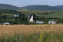
- Hažlín
-
Hažlín
Wappen Karte  Basisdaten
Kraj: Prešovský kraj Okres: Bardejov Region: Šariš Fläche: 20,099 km² Einwohner: 1.152 (31. Dez. 2010) Bevölkerungsdichte: 57,32 Einwohner je km² Höhe: 281 m n.m. Postleitzahl: 086 14 Telefonvorwahl: 0 54 Geographische Lage: 49° 18′ N, 21° 25′ O49.30277777777821.419444444444281Koordinaten: 49° 18′ 10″ N, 21° 25′ 10″ O Kfz-Kennzeichen: BJ Gemeindekennziffer: 519227 StrukturGemeindeart: Gemeinde Verwaltung (Stand: Juli 2011)Bürgermeister: František Olah Adresse: Obecný úrad Hažlín
Hlavná 200
086 14 HažlínWebpräsenz: www.obechazlin.sk Gemeindeinformation
auf portal.gov.skStatistikinformation
auf statistics.skHažlín (ungarisch Hazslin) ist ein Ort und eine Gemeinde im Osten der Slowakei, mit 1152 Einwohnern (Stand 31. Dezember 2010). Sie gehört zum Okres Bardejov (Prešovský kraj).
Inhaltsverzeichnis
Geographie
Der Ort liegt im Bergland Ondavská vrchovina (Teil der Niederen Beskiden) an mehreren Bächen, die den Ort als Hažlínka verlassen. Nordwestlich des Ortes liegt der „Hausberg“ Kačalová (677 m n.m.). Hažlín ist 13 Kilometer von Bardejov entfernt.
Geschichte
Hažlín wird zum ersten Mal in einer Urkunde, datiert am 12. April 1414 als Henslengh schriftlich erwähnt und war Teil des Herrschaftsgut von Makovica. Indirekte Erwähnungen gibt es aber schon im 13. und 14. Jahrhundert.
Sehenswürdigkeiten
- römisch-katholische Kirche aus dem Jahr 1750
Weblinks
Abrahámovce | Andrejová | Bardejov (Bartfeld) | Bartošovce | Becherov | Beloveža | Bogliarka | Brezov | Brezovka | Buclovany | Cigeľka | Dubinné | Frička (Fritsch) | Fričkovce (Fritschhau) | Gaboltov | Gerlachov (Gerlachau) | Hankovce | Harhaj | Hažlín | Hertník (Herknecht) | Hervartov (Herbertsdorf) | Hrabovec | Hrabské | Hutka | Chmeľová | Janovce (Johannsdorf) | Jedlinka | Kľušov | Kobyly | Kochanovce | Komárov | Koprivnica | Kožany | Krivé | Kríže | Kružlov | Kučín | Kurima | Kurov | Lascov | Lenartov | Lipová | Livov | Livovská Huta (Hütten) | Lopúchov | Lukavica | Lukov (Dornau) | Malcov | Marhaň | Mikulášová | Mokroluh | Nemcovce | Nižná Polianka | Nižná Voľa | Nižný Tvarožec | Oľšavce | Ondavka | Ortuťová | Osikov | Petrová | Poliakovce | Porúbka | Raslavice | Regetovka | Rešov | Richvald (Reichwald) | Rokytov | Smilno | Snakov | Stebnícka Huta (Glashütte) | Stebník (Stebnik) | Stuľany | Sveržov | Šarišské Čierne | Šašová | Šiba (Scheibe) | Tarnov | Tročany | Vaniškovce | Varadka | Vyšná Polianka | Vyšná Voľa | Vyšný Kručov | Vyšný Tvarožec | Zborov | Zlaté
Wikimedia Foundation.


