- Jugovzhodna Slovenija
-
 Statistische Region Jugovzhodna Slovenija
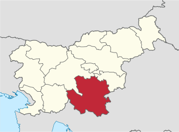
Jugovzhodna Slovenija (slowenisch: Jugovzhodna Slovenija statistična regija) ist eine statistische Region in Slowenien auf NUTS Ebene.
Die Region, die für statistische Zwecke bestimmt ist, wurde im Mai 2005 eingeführt. Sie umfasst insgesamt 20 Gemeinden. Die größte Stadt ist Novo mesto. Die Gesamtfläche beträgt 2783 km². Die Einwohnerzahl beträgt 142.180.
Wappen Gemeinde Deutscher Name Karte Fläche km² Einwohnerzahl (2008) Einwohner pro km² NUTS3-Code 
Črnomelj Tschernembl 
339.7 14.936 44 ? 
Dolenjske Toplice Töplitz 
110.2 3.494 32 ? 
Kočevje Gottschee 
564.0 16.999 30 ? 
Kostel Grafenwarth 
56.1 681 12 ? 
Loški Potok Laserbach 
134.5 2.042 15 ? 
Metlika Möttling 
108.9 8.499 78 ? 
Mirna Peč Hönigstein 
48.0 2.927 59 ? 
Mokronog-Trebelno Nassenfuß - Trebelen 
71.0 2.948 41 ? 
Novo mesto Neustädtel 
298.5 40.925 137 ? 
Osilnica Ossilnitz 
36.2 430 12 ? 
Ribnica Reifnitz 
153.6 9.326 61 ? 
Semič Semitsch 
146.7 3.901 27 ? 
Sodražica Soderschitz 
49.5 2.220 45 ? 
Straža 
28.5 3.856 135 ? 
Šentjernej Sankt Bartholomä 
96.0 6.791 71 ? 
Šentrupert Sankt Ruprecht 
42.0 2.419 57 ? 
Škocjan Sankt Kanzian 
60.4 3.223 53 ? 
Šmarješke Toplice 
3.101 ? 
Trebnje Treffen 
317.1 14.350 45 ? 
Žužemberk Seisenberg 
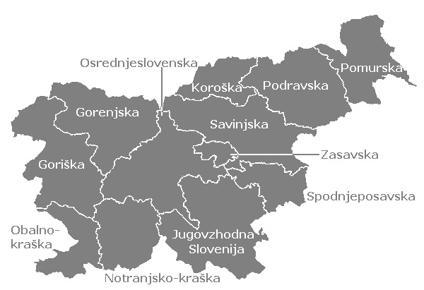
164.3 4.632 28 ? gesamt: 2783.2 142.180 51  Statistische Regionen in Slowenien
Gorenjska | Goriška | Jugovzhodna Slovenija | Koroška | Notranjsko-kraška | Obalno-kraška | Osrednjeslovenska | Podravska | Pomurska | Savinjska | Spodnjeposavska | Zasavska
Wikimedia Foundation.
Schlagen Sie auch in anderen Wörterbüchern nach:
Jugovzhodna Slovenija — (n.º 3, en rojo) en Eslovenia. La región de Jugovzhodna Slovenija (en esloveno Jugovzhodna Slovenija; Eslovenia suroriental) es una de las doce regiones estadísticas en las que se subdivide Eslovenia. En diciembre de 2005, contaba con una… … Wikipedia Español
Jugovzhodna Slovenija statistical region — Southeast Slovenia statistical region Jugovzhodna Slovenija statistična regija Statistical region … Wikipedia
Republika Slovenija — Republik Slowenien … Deutsch Wikipedia
Žužemberk — Bandera … Wikipedia Español
NUTS of Slovenia — Main article: Nomenclature of Territorial Units for Statistics In the NUTS (Nomenclature of Territorial Units for Statistics) codes of Slovenia (SI), the three levels are: Level Subdivisions # NUTS 1 1 NUTS 2 Macroregions (Kohezijske regije) 2… … Wikipedia
Liste der Gemeinden in Slowenien — Dies ist eine Liste der Städte und Gemeinden in Slowenien, nach Einwohnerzahl und alphabetisch geordnet. Nach Einwohnerzahl Die mit Abstand größte Agglomeration in Slowenien ist Ljubljana (dt. Laibach) mit einer Einwohnerzahl von 491.407 (Stand 1 … Deutsch Wikipedia
Liste der Städte in Slowenien — Dies ist eine Liste der Städte und Gemeinden in Slowenien, nach Einwohnerzahl und alphabetisch geordnet. Nach Einwohnerzahl Die mit Abstand größte Agglomeration in Slowenien ist Ljubljana (dt. Laibach) mit einer Einwohnerzahl von 491.407 (Stand 1 … Deutsch Wikipedia
Cerov Log — Cerov Log … Wikipedia
Čisti Breg — Čisti Breg … Wikipedia
Čurile — Čurile … Wikipedia
Jugovzhodna Slovenija

18+
© Academic, 2000-2026
- Kontaktieren Sie uns: Unterstützung, Werbung
Wörterbücher Export, schritte mit PHP, Joomla, Drupal, WordPress, MODx.