- Kostomłoty
-
Kostomłoty 


Kostomłoty Basisdaten Staat: Polen Woiwodschaft: Niederschlesien Landkreis: Środa Śląska Geographische Lage: 51° 3′ N, 16° 37′ O51.0516.616666666667Koordinaten: 51° 3′ 0″ N, 16° 37′ 0″ O Höhe: 150 m n.p.m Einwohner: -
(31. Dez. 2010)[1]Postleitzahl: 55-311 Telefonvorwahl: (+48) 71 Kfz-Kennzeichen: DSR Wirtschaft und Verkehr Nächster int. Flughafen: Breslau Gemeinde Gemeindeart: Landgemeinde Fläche: 146,3 km² Einwohner: 6990
(31. Dez. 2010) [2]Bevölkerungsdichte: 48 Einw./km² Gemeindenummer (GUS): 0218012 Verwaltung (Stand: 2006) Bürgermeister: Wacław Jaskuła Adresse: ul. Ślężna 2
55-311 KostomłotyWebpräsenz: www.kostomloty.pl Kostomłoty (deutsch: Kostenblut) ist ein Ort im Powiat Średzki in der Woiwodschaft Niederschlesien in Polen.
Inhaltsverzeichnis
Geschichte
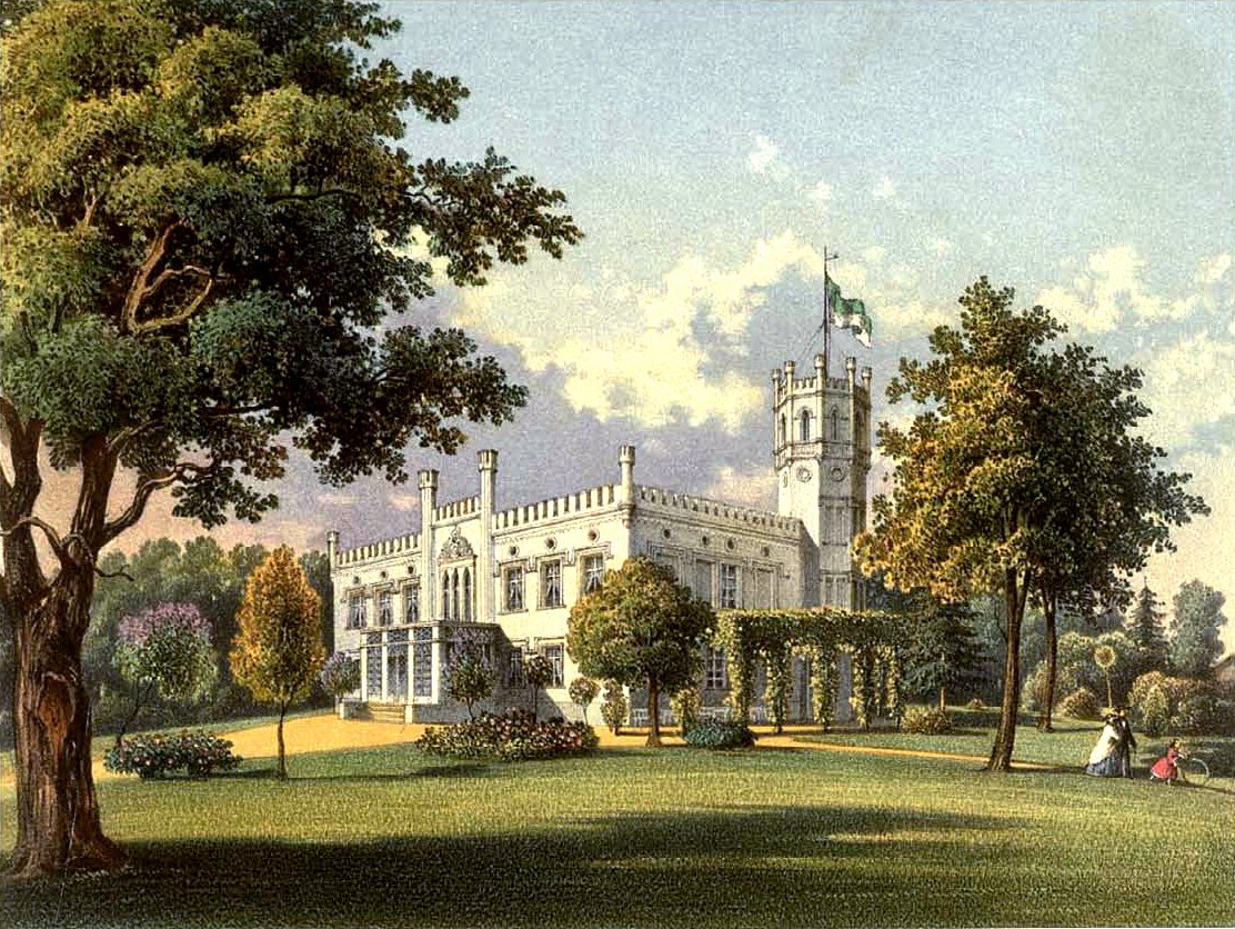
 Schloss Pirschen um 1860, Sammlung Alexander Duncker
Bis 1945 war Kostenblut eine Gemeinde im Landkreis Neumarkt, Regierungsbezirk Breslau der Provinz Schlesien.
Gemeinde
Die Landgemeinde Kostomłoty besteht aus folgenden Ortsteilen (deutsche Namen bis 1945)[3] mit einem Schulzenamt::
- Bogdanów (Neuhof)
- Budziszów (Baudis-Meesendorf)
- Chmielów (Schmellwitz)
- Czechy (Tschechen, 1939–1945: Erlenhain)
- Godków (Guckelhausen)
- Jakubkowice (Jakobsdorf)
- Jarząbkowice (Schriegwitz)
- Jenkowice (Jenkwitz)
- Karczyce (Kertschütz)
- Kostomłoty (Kostenblut)
- Lisowice (Onerkwitz)
- Mieczków (Metschkau)
- Osiek (Ossig)
- Paździorno (Pohlsdorf)
- Piersno (Pirschen-Stusa)
- Piotrowice (Groß Peterwitz)
- Pustynka
- Ramułtowice (Illnisch-Romolkwitz, 1939–1945: Ramfeld)
- Samborz (Tschammendorf)
- Samsonowice (Spillendorf)
- Siemidrożyce (Schöbekirch)
- Sikorzyce
- Sobkowice (Zopkendorf)
- Szymanowice (Schönbach)
- Świdnica Polska (Polnisch Schweinitz, 1939–1945: Schweinitz b. Kanth)
- Wichrów (Weicherau)
- Wilków Średzki (Wilkau-Zopkendorf)
- Wnorów (Karlsberg)
- Zabłoto (Sablath, 1939–1945: Gräbendorf)
Weblinks
Einzelnachweise
- ↑ Population. Size and Structure by Territorial Division. As of June 30, 2010. Główny Urząd Statystyczny (GUS), abgerufen am 30. Juli 2011.
- ↑ Population. Size and Structure by Territorial Division. As of June 30, 2010. Główny Urząd Statystyczny (GUS), abgerufen am 30. Juli 2011.
- ↑ Das Genealogische Orts-Verzeichnis
Städte und Gemeinden im Powiat ŚredzkiKostomłoty (Kostenblut) | Malczyce (Maltsch) | Miękinia (Nimkau) | Środa Śląska (Neumarkt in Schlesien) – Stadt | Udanin (Gäbersdorf)
Wikimedia Foundation.
Schlagen Sie auch in anderen Wörterbüchern nach:
Kostomłoty — may refer to the following places in Poland: *Kostomłoty, Lower Silesian Voivodeship (south west Poland) *Kostomłoty, Lublin Voivodeship (east Poland) … Wikipedia
Kostomłoty (Lublin Voivodeship) — Kostomłoty are a village in the Lublin Voivodeship of Poland, located 14 km S of Terespol on the border with Belarus at coord|51|58|32|N|23|39|29|E|display=inline,title, with about 750 citizens.First written mention of the settlement comes from… … Wikipedia
Kostomłoty, Lower Silesian Voivodeship — Infobox Settlement name = Kostomłoty settlement type = Village total type = image shield = subdivision type = Country subdivision name = POL subdivision type1 = Voivodeship subdivision name1 = Lower Silesian subdivision type2 = County subdivision … Wikipedia
Kostomłoty Drugie — Infobox Settlement name = Kostomłoty Drugie settlement type = Village total type = image shield = subdivision type = Country subdivision name = POL subdivision type1 = Voivodeship subdivision name1 = Świętokrzyskie subdivision type2 = County… … Wikipedia
Kostomłoty Pierwsze — Infobox Settlement name = Kostomłoty Pierwsze settlement type = Village total type = image shield = subdivision type = Country subdivision name = POL subdivision type1 = Voivodeship subdivision name1 = Świętokrzyskie subdivision type2 = County… … Wikipedia
Kostomloty Pierwsze — Original name in latin Kostomoty Pierwsze Name in other language Kostomloty Pierwsze, Kostomoty Pierwsze, Zamlynie Kostomloty, Zamynie Kostomoty State code PL Continent/City Europe/Warsaw longitude 50.92322 latitude 20.5949 altitude 273… … Cities with a population over 1000 database
Kostomloty Drugie — Original name in latin Kostomoty Drugie Name in other language Kostomloty, Kostomoty State code PL Continent/City Europe/Warsaw longitude 50.92684 latitude 20.56529 altitude 288 Population 1522 Date 2010 10 13 … Cities with a population over 1000 database
Gmina Kostomłoty — Infobox Settlement name = Gmina Kostomłoty other name = Kostomłoty Commune settlement type = Gmina total type = Total image shield = subdivision type = Country subdivision name = POL subdivision type1 = Voivodeship subdivision name1 = Lower… … Wikipedia
Mieczków — Village … Wikipedia
Гмина Костомлоты — Gmina Kostomłoty Герб Файл:Kostomlotycoa.JPG Страна: Польша Повят: Сьродский повят (Нижнесилезское воеводство) Глава: Вацлав Яскула (2006) Площадь: 146,25 км² Население … Википедия
Kostomłoty


18+
© Academic, 2000-2024
- Kontaktieren Sie uns: Unterstützung, Werbung
Wörterbücher Export, schritte mit PHP, Joomla, Drupal, WordPress, MODx.