Mārupe

Mārupe
Mārupe
Wappen fehlt
Hilfe zu Wappen
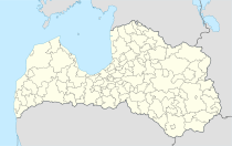
Mārupe (Lettland)
Red pog.svg
Basisdaten
Staat: Lettland
Landschaft: Livland (lettisch: Vidzeme)
Verwaltungsbezirk: Mārupes novads
Koordinaten: 56° 54′ N, 24° 3′ O56.90083333333324.04777777777810Koordinaten: 56° 54′ 3″ N, 24° 2′ 52″ O
Einwohner: 5.510 (17. Nov. 2006)
Fläche:
Bevölkerungsdichte:
Höhe: 10 m NAP
Webseite: www.marupe.lv

Mārupe ist ein südwestlicher Vorort von Riga in Lettland und Zentrum des gleichnamigen Bezirks (Mārupes novads) welcher 2009 ohne Gebietsveränderung aus der Gemeinde entstand.

Im Gemeindegebiet befinden sich ausgedehnte Sumpfgebiete.

Literatur


Wikimedia Foundation.

Игры ⚽ Поможем написать реферат

Schlagen Sie auch in anderen Wörterbüchern nach:

  • Mārupe —   Village   …   Wikipedia

  • Marupė — Sp Márupė Ap Mārupe L Latvija …   Pasaulio vietovardžiai. Internetinė duomenų bazė

  • Mārupe — Sp Márupė Ap Mārupe L Latvija …   Pasaulio vietovardžiai. Internetinė duomenų bazė

  • Mārupe municipality — Mārupes novads Centre: Mārupe …   Wikipedia

  • Marupe — Original name in latin Mrupe Name in other language State code LV Continent/City Europe/Riga longitude 56.90544 latitude 24.05113 altitude 11 Population 0 Date 2013 06 30 …   Cities with a population over 1000 database

  • Municipalidad de Mārupe — Municipalidad de Mārupes Mārupes novads Municipalidad de Letonia …   Wikipedia Español

  • Марупский край — Mārupes novads …   Википедия

  • Rīgas rajons — Der Rīgas rajons (deutsch: Landkreis Riga) war bis 2009 eine Verwaltungseinheit in Lettland rund um die Hauptstadt Riga. Der Rajon grenzte im Norden an die Rigaer Bucht und im Gegenuhrzeigersinn an die Landkreise Tukums, Jelgava, Bauska, Ogre,… …   Deutsch Wikipedia

  • Mālpils municipality — Mālpils novads …   Wikipedia

  • Ogre municipality — Ogres novads Centre: Ogre, Latvia …   Wikipedia

Share the article and excerpts

Direct link
Do a right-click on the link above
and select “Copy Link”