Orzyc

Orzyc
Orzyc
Orzycz, Orzyca, OrschützVorlage:Infobox Fluss/GKZ_fehlt
Lage Woiwodschaft Masowien, Woiwodschaft Ermland-Masuren, Polen
Flusssystem Weichsel
Abfluss über Narew → Weichsel → Ostsee
Quelle östlich von MławaVorlage:Infobox Fluss/QUELLKOORDINATE_fehltVorlage:Infobox Fluss/QUELLHÖHE_fehlt
Mündung bei Przeradowo in den Narew
52.76666666666721.2

52° 46′ 0″ N, 21° 12′ 0″ O52.76666666666721.2
Vorlage:Infobox Fluss/MÜNDUNGSHÖHE_fehltVorlage:Infobox Fluss/HÖHENUNTERSCHIED_fehlt
Länge 146 kmVorlage:Infobox Fluss/NACHWEISE_fehlen
Einzugsgebiet 2.077 km²Vorlage:Infobox Fluss/NACHWEISE_fehlen

Vorlage:Infobox Fluss/ABFLUSS_fehlt

Rechte Nebenflüsse Tamka, Bobrynka, Ulatówka, Bramura, Węgierka
Linke Nebenflüsse Grabowski Rów, Baranowska Struga
Kleinstädte Chorzele, Maków Mazowiecki
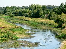
Vorlage:Infobox Fluss/BILD_fehlt
Die Orzyc

Die Orzyc [ˈɔʒɨt͡s] (deutsch Orschütz) ist ein rechter Zufluss des Narew in Polen. Sie entspringt östlich von Mława im Grenzgebiet der Woiwodschaft Ermland-Masuren und der Woiwodschaft Masowien, fließt zunächst in nordnordöstlicher und sodann in südöstlicher Richtung, durchfließt Chorzele, wendet sich ann nach Süden und durchläuft Maków Mazowiecki. Bei Przeradowo mündet sie nach einem Lauf von 146 km in den Narew. Ihr Einzugsgebiet wird mit 2077 km² angegeben.


Wikimedia Foundation.

Игры ⚽ Нужно решить контрольную?

Schlagen Sie auch in anderen Wörterbüchern nach:

  • Orzyc — Orzyc, Nebenfluß des Narew im preußischen Regierungsbezirk Königsberg; bildet auf 2 Meilen die Grenze gegen Russisch Polen …   Pierer's Universal-Lexikon

  • Orzyc — Sp Òžycas Ap Orzyc L u. R Lenkijoje …   Pasaulio vietovardžiai. Internetinė duomenų bazė

  • Orzyc, Masovian Voivodeship — Orzyc   Village   …   Wikipedia

  • Narew — See also: Narew, Podlaskie Voivodeship Coordinates: 52°26′N 20°41′E / 52.433°N 20.683°E / 52.433; 20.683 …   Wikipedia

  • Maków Mazowiecki — Orzyc river in Maków …   Wikipedia

  • Puszcza Zielona — (the Green Wilderness) is a forest in Poland which extends from the Narew River and the border of what was once East Prussia. It is bounded on the east by the Pisa River and on the west by the Orzyc River. The forest lies in a lowland and… …   Wikipedia

  • Narew — in Strękowa GóraVorlage:Infobox Fluss/KARTE fehlt Daten …   Deutsch Wikipedia

  • Bassin de la Vistule — Le bassin versant de la Vistule s étend sur 194 424 km² ce qui représente plus de 60% de toute la Pologne et toute sa partie orientale (le reste du pays est principalement drainé par l Oder (en polonais Odra). bassin de la Vistule Le point le… …   Wikipédia en Français

  • Narew — 52° 26′ 01″ N 20° 40′ 37″ E / 52.4335, 20.677 …   Wikipédia en Français

  • Mazovia (región) — División histórica de Mazovia Mazovia o Masovia (en polaco Mazowsze) es una región geográfica, histórica y cultural ubicada en el centro este del actual territorio de Polonia; su ciudad principal es Varsovia. La Mazovia limita al norte con la… …   Wikipedia Español

Share the article and excerpts

Direct link
Do a right-click on the link above
and select “Copy Link”